Sterling County Sketch File 24
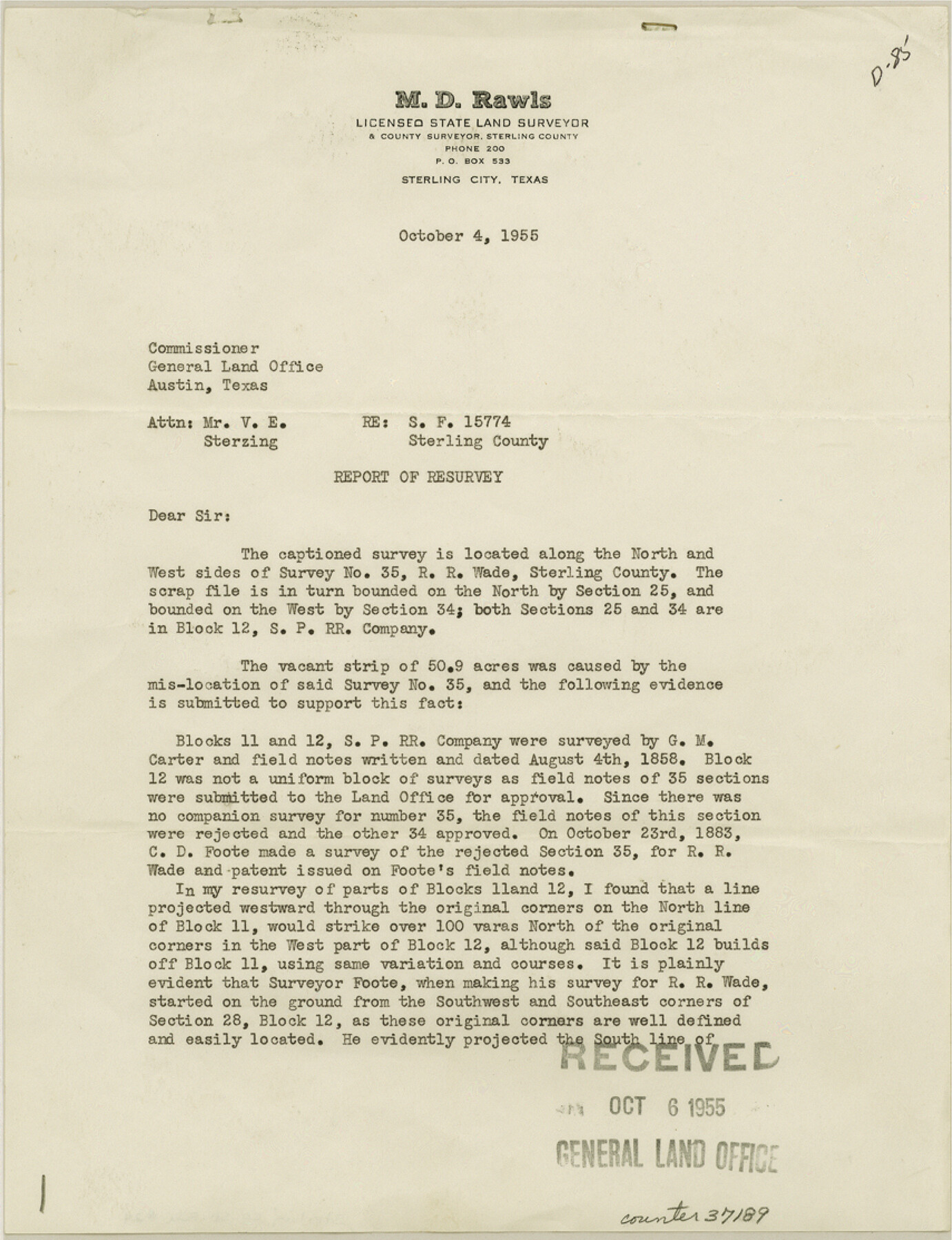
[Report in connection with SF-15774 and a resurvey of parts of S. P. RR. Co. Blocks 11 and 12 and H. & T. C. RR. Co. Block 15]
-
Map/Doc
37189
-
Collection
General Map Collection
-
Object Dates
10/4/1955 (Creation Date)
10/6/1955 (File Date)
10/1/1955 (Correspondence Date)
8/14/1858 (Survey Date)
10/23/1883 (Survey Date)
-
People and Organizations
M.D. Rawls (Surveyor/Engineer)
G.M. Carter (Surveyor/Engineer)
C.D. Foote (Surveyor/Engineer)
-
Counties
Sterling
-
Subjects
Surveying Sketch File
-
Height x Width
11.1 x 8.5 inches
28.2 x 21.6 cm
-
Medium
paper, print
Part of: General Map Collection
Reagan County Sketch File 20

Print $4.00
- Digital $50.00
Reagan County Sketch File 20
Size 14.5 x 9.0 inches
Map/Doc 35011
No. 1 - Survey for a road from the Brazo Santiago to the Rio Grande

Print $20.00
- Digital $50.00
No. 1 - Survey for a road from the Brazo Santiago to the Rio Grande
1847
Size 18.3 x 27.1 inches
Map/Doc 72876
Flight Mission No. BRA-7M, Frame 34, Jefferson County

Print $20.00
- Digital $50.00
Flight Mission No. BRA-7M, Frame 34, Jefferson County
1953
Size 18.6 x 22.3 inches
Map/Doc 85485
[Surveys along the Leona and Frio Rivers]
![16, [Surveys along the Leona and Frio Rivers], General Map Collection](https://historictexasmaps.com/wmedia_w700/maps/16.tif.jpg)
Print $20.00
- Digital $50.00
[Surveys along the Leona and Frio Rivers]
1841
Size 12.4 x 13.1 inches
Map/Doc 16
Liberty County Working Sketch 5

Print $20.00
- Digital $50.00
Liberty County Working Sketch 5
1901
Size 41.9 x 36.5 inches
Map/Doc 70464
Caldwell County Working Sketch 6

Print $20.00
- Digital $50.00
Caldwell County Working Sketch 6
1958
Size 21.8 x 26.3 inches
Map/Doc 67836
Kent County Sketch File 15

Print $8.00
- Digital $50.00
Kent County Sketch File 15
1936
Size 11.4 x 7.2 inches
Map/Doc 28842
Montgomery County

Print $20.00
- Digital $50.00
Montgomery County
1901
Size 21.9 x 25.3 inches
Map/Doc 3898
Tyler County Rolled Sketch 12

Print $20.00
- Digital $50.00
Tyler County Rolled Sketch 12
1988
Size 25.2 x 19.3 inches
Map/Doc 8060
Military Reconnaissance [showing forts along Rio Grande near Matamoros]
![72911, Military Reconnaissance [showing forts along Rio Grande near Matamoros], General Map Collection](https://historictexasmaps.com/wmedia_w700/maps/72911.tif.jpg)
Print $20.00
- Digital $50.00
Military Reconnaissance [showing forts along Rio Grande near Matamoros]
1846
Size 18.2 x 27.2 inches
Map/Doc 72911
Flight Mission No. DQO-6K, Frame 33, Galveston County

Print $20.00
- Digital $50.00
Flight Mission No. DQO-6K, Frame 33, Galveston County
1952
Size 18.8 x 22.4 inches
Map/Doc 85099
Henderson County Boundary File 3a

Print $30.00
- Digital $50.00
Henderson County Boundary File 3a
Size 14.4 x 8.9 inches
Map/Doc 54685
You may also like
Duval County Rolled Sketch 50

Print $20.00
- Digital $50.00
Duval County Rolled Sketch 50
1876
Size 14.2 x 11.8 inches
Map/Doc 5764
Medina County

Print $40.00
- Digital $50.00
Medina County
1976
Size 50.6 x 40.9 inches
Map/Doc 77370
General Highway Map. Detail of Cities and Towns in Potter County, Texas [Amarillo and vicinity]
![79221, General Highway Map. Detail of Cities and Towns in Potter County, Texas [Amarillo and vicinity], Texas State Library and Archives](https://historictexasmaps.com/wmedia_w700/maps/79221.tif.jpg)
Print $20.00
General Highway Map. Detail of Cities and Towns in Potter County, Texas [Amarillo and vicinity]
1940
Size 24.6 x 18.2 inches
Map/Doc 79221
Lubbock County Boundary File 6

Print $58.00
- Digital $50.00
Lubbock County Boundary File 6
Size 4.7 x 7.0 inches
Map/Doc 56494
Hansford County

Print $20.00
- Digital $50.00
Hansford County
1932
Size 38.7 x 38.0 inches
Map/Doc 73169
Cottle County Sketch File 2

Print $20.00
- Digital $50.00
Cottle County Sketch File 2
1882
Size 32.9 x 19.6 inches
Map/Doc 76757
Matagorda County Working Sketch 30

Print $20.00
- Digital $50.00
Matagorda County Working Sketch 30
1981
Size 21.0 x 19.7 inches
Map/Doc 70888
Baylor County, Texas

Print $20.00
- Digital $50.00
Baylor County, Texas
1879
Size 22.2 x 17.4 inches
Map/Doc 586
Kleberg County Rolled Sketch 7

Print $20.00
- Digital $50.00
Kleberg County Rolled Sketch 7
1947
Size 28.5 x 41.4 inches
Map/Doc 6550
Montague County Working Sketch 41

Print $40.00
- Digital $50.00
Montague County Working Sketch 41
1923
Size 43.3 x 70.1 inches
Map/Doc 65350
Matagorda Light to Aransas Pass

Print $20.00
- Digital $50.00
Matagorda Light to Aransas Pass
1924
Size 35.9 x 44.6 inches
Map/Doc 73391
Lynn County Rolled Sketch 14

Print $20.00
- Digital $50.00
Lynn County Rolled Sketch 14
1952
Size 35.4 x 35.3 inches
Map/Doc 9474