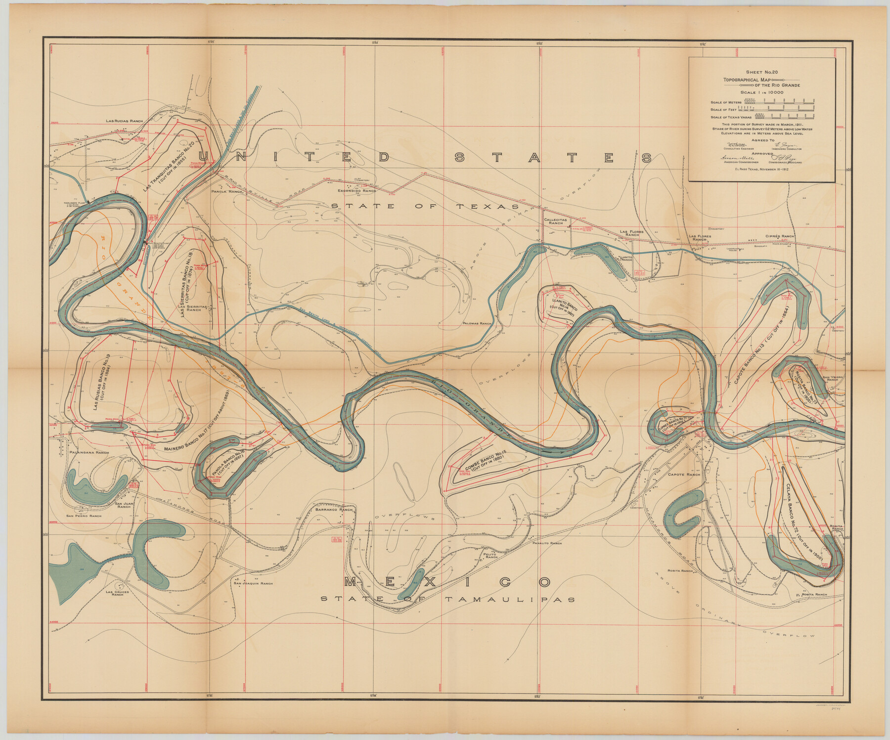
Topographical Map of the Rio Grande, Sheet No. 20
[from book: "Survey of the Rio Grande, Roma to the Gulf of Mexico, Reports and Maps"]
-
Map/Doc
89544
-
Collection
General Map Collection
-
Object Dates
1912/11/16 (Creation Date)
-
People and Organizations
International Boundary Commission (Publisher)
Anson Mills (Author)
E. Zayas (Surveyor/Engineer)
F.B. Puga (Author)
W.W. Follett (Surveyor/Engineer)
-
Subjects
River Surveys Texas Boundaries Topographic
-
Medium
paper
-
Scale
1:10000
-
Comments
This portion of the survey made in March, 1911. State of river during survey 0.2 meters above low water. Elevations are in meters above sea level. This map and 31 others were originally folded and bound into a book titled "Survey of the Rio Grande, R
Part of: General Map Collection
Southern Part of Laguna Madre

Print $20.00
- Digital $50.00
Southern Part of Laguna Madre
1966
Size 44.3 x 34.8 inches
Map/Doc 73540
Morris County Rolled Sketch 2A

Print $20.00
- Digital $50.00
Morris County Rolled Sketch 2A
Size 24.0 x 18.6 inches
Map/Doc 10235
[Location Survey of the Southern Kansas Railway, Kiowa Extension from a point in Drake's Location, in Indian Territory 100 miles from south line of Kansas, continuing up Wolf Creek and South Canadian River to Cottonwood Creek in Hutchinson County]
![88839, [Location Survey of the Southern Kansas Railway, Kiowa Extension from a point in Drake's Location, in Indian Territory 100 miles from south line of Kansas, continuing up Wolf Creek and South Canadian River to Cottonwood Creek in Hutchinson County], General Map Collection](https://historictexasmaps.com/wmedia_w700/maps/88839.tif.jpg)
Print $20.00
- Digital $50.00
[Location Survey of the Southern Kansas Railway, Kiowa Extension from a point in Drake's Location, in Indian Territory 100 miles from south line of Kansas, continuing up Wolf Creek and South Canadian River to Cottonwood Creek in Hutchinson County]
1886
Size 38.9 x 36.0 inches
Map/Doc 88839
Gregg County Sketch File 1A

Print $6.00
- Digital $50.00
Gregg County Sketch File 1A
1847
Size 8.3 x 7.6 inches
Map/Doc 24535
Armstrong County Sketch File A-6

Print $40.00
- Digital $50.00
Armstrong County Sketch File A-6
1919
Size 18.3 x 15.8 inches
Map/Doc 10847
Young County Sketch File 12

Print $4.00
- Digital $50.00
Young County Sketch File 12
1889
Size 8.5 x 13.6 inches
Map/Doc 40876
Johnson County Working Sketch 32

Print $20.00
- Digital $50.00
Johnson County Working Sketch 32
2008
Size 29.2 x 27.4 inches
Map/Doc 88817
Duval County Rolled Sketch HO and R

Print $40.00
- Digital $50.00
Duval County Rolled Sketch HO and R
1933
Size 65.8 x 43.1 inches
Map/Doc 8807
Hale County Sketch File 22

Print $8.00
- Digital $50.00
Hale County Sketch File 22
1903
Size 11.1 x 8.6 inches
Map/Doc 24755
Duval County Sketch File 27

Print $6.00
- Digital $50.00
Duval County Sketch File 27
1919
Size 11.0 x 11.8 inches
Map/Doc 21334
Parker County Sketch File 2

Print $4.00
- Digital $50.00
Parker County Sketch File 2
1856
Size 12.7 x 8.2 inches
Map/Doc 33519
Flight Mission No. DQO-8K, Frame 87, Galveston County

Print $20.00
- Digital $50.00
Flight Mission No. DQO-8K, Frame 87, Galveston County
1952
Size 18.6 x 22.4 inches
Map/Doc 85189
You may also like
Val Verde County Working Sketch 74

Print $20.00
- Digital $50.00
Val Verde County Working Sketch 74
1970
Size 30.7 x 28.3 inches
Map/Doc 72209
Coast of Texas and its defences

Print $20.00
- Digital $50.00
Coast of Texas and its defences
1864
Size 27.3 x 18.1 inches
Map/Doc 72683
Flight Mission No. DAH-9M, Frame 200, Orange County

Print $20.00
- Digital $50.00
Flight Mission No. DAH-9M, Frame 200, Orange County
1953
Size 18.6 x 22.4 inches
Map/Doc 86868
Americae Nova Descriptio

Print $20.00
- Digital $50.00
Americae Nova Descriptio
1663
Size 14.5 x 18.0 inches
Map/Doc 95708
Borden County Rolled Sketch 7

Print $20.00
- Digital $50.00
Borden County Rolled Sketch 7
Size 16.9 x 18.5 inches
Map/Doc 5157
Traveller's Map of the State of Texas

Print $20.00
- Digital $50.00
Traveller's Map of the State of Texas
1867
Size 41.8 x 38.9 inches
Map/Doc 4328
South Part of Webb County

Print $40.00
- Digital $50.00
South Part of Webb County
1984
Size 43.5 x 63.9 inches
Map/Doc 73320
Kent County, 1898

Print $20.00
- Digital $50.00
Kent County, 1898
1898
Size 38.1 x 41.6 inches
Map/Doc 89706
Galveston Entrance, Texas From a Trigonometrical Survey Under the direction of A.D. Bache Superintendent of the Survey of the Coast of the United States

Print $20.00
- Digital $50.00
Galveston Entrance, Texas From a Trigonometrical Survey Under the direction of A.D. Bache Superintendent of the Survey of the Coast of the United States
1853
Size 15.9 x 19.3 inches
Map/Doc 93998
Coleman County Working Sketch 8

Print $20.00
- Digital $50.00
Coleman County Working Sketch 8
1946
Size 39.3 x 33.3 inches
Map/Doc 68074
Coryell County Working Sketch 2

Print $20.00
- Digital $50.00
Coryell County Working Sketch 2
1906
Size 15.3 x 18.5 inches
Map/Doc 68209
[Blocks M18, M23, I, Z, and Block 47, Sections 16-28]
![91244, [Blocks M18, M23, I, Z, and Block 47, Sections 16-28], Twichell Survey Records](https://historictexasmaps.com/wmedia_w700/maps/91244-1.tif.jpg)
Print $20.00
- Digital $50.00
[Blocks M18, M23, I, Z, and Block 47, Sections 16-28]
Size 19.5 x 23.6 inches
Map/Doc 91244