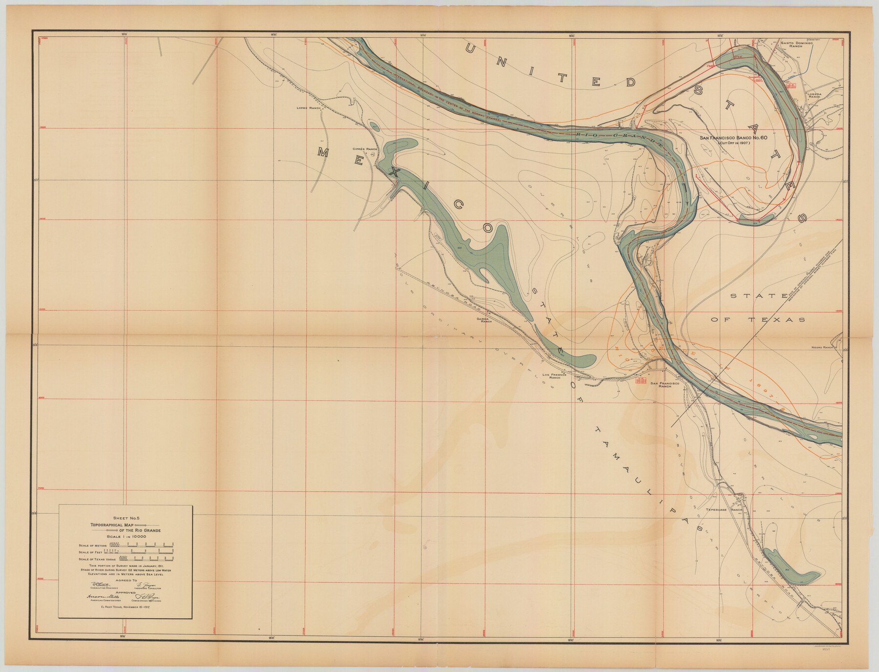
Topographical Map of the Rio Grande, Sheet No. 5
[from book: "Survey of the Rio Grande, Roma to the Gulf of Mexico, Reports and Maps"]
-
Map/Doc
89529
-
Collection
General Map Collection
-
Object Dates
1912/11/16 (Creation Date)
-
People and Organizations
International Boundary Commission (Publisher)
Anson Mills (Author)
E. Zayas (Surveyor/Engineer)
F.B. Puga (Author)
W.W. Follett (Surveyor/Engineer)
-
Subjects
River Surveys Texas Boundaries Topographic
-
Medium
paper
-
Scale
1:10000
-
Comments
This portion of the survey made in January, 1911. State of river during survey 0.2 meters above low water. Elevations are in meters above sea level. This map and 31 others were originally folded and bound into a book titled "Survey of the Rio Grande,
Part of: General Map Collection
Goliad County Sketch File 3

Print $4.00
- Digital $50.00
Goliad County Sketch File 3
1852
Size 12.4 x 8.2 inches
Map/Doc 24214
Grayson County Sketch File 22

Print $4.00
- Digital $50.00
Grayson County Sketch File 22
1871
Size 10.4 x 8.4 inches
Map/Doc 24501
Palo Pinto County Sketch File 6a

Print $20.00
- Digital $50.00
Palo Pinto County Sketch File 6a
Size 37.8 x 38.6 inches
Map/Doc 10565
Presidio County Sketch File 105

Print $20.00
- Digital $50.00
Presidio County Sketch File 105
Size 15.6 x 42.6 inches
Map/Doc 11726
Collin County

Print $20.00
- Digital $50.00
Collin County
1975
Size 43.2 x 40.1 inches
Map/Doc 73110
Flight Mission No. CRC-2R, Frame 194, Chambers County

Print $20.00
- Digital $50.00
Flight Mission No. CRC-2R, Frame 194, Chambers County
1956
Size 18.8 x 22.6 inches
Map/Doc 84772
Ward County Rolled Sketch 24F

Print $40.00
- Digital $50.00
Ward County Rolled Sketch 24F
1967
Size 43.0 x 72.4 inches
Map/Doc 10117
Fort Bend County State Real Property Sketch 4

Print $40.00
- Digital $50.00
Fort Bend County State Real Property Sketch 4
1987
Size 36.3 x 47.9 inches
Map/Doc 61678
Burnet County Sketch File 11

Print $40.00
- Digital $50.00
Burnet County Sketch File 11
1848
Size 12.8 x 15.2 inches
Map/Doc 16692
Culberson County Sketch File 21

Print $20.00
- Digital $50.00
Culberson County Sketch File 21
1937
Size 11.2 x 8.8 inches
Map/Doc 20224
Colorado County Sketch File 16a

Print $4.00
- Digital $50.00
Colorado County Sketch File 16a
Size 12.7 x 8.1 inches
Map/Doc 18947
Map of Schleicher County

Print $20.00
- Digital $50.00
Map of Schleicher County
1887
Size 21.4 x 30.1 inches
Map/Doc 4021
You may also like
Bastrop County Rolled Sketch 1

Print $20.00
- Digital $50.00
Bastrop County Rolled Sketch 1
Size 30.0 x 23.9 inches
Map/Doc 5121
Hardin County Sketch File 10

Print $4.00
- Digital $50.00
Hardin County Sketch File 10
1862
Size 12.5 x 8.0 inches
Map/Doc 25110
Jeff Davis County Rolled Sketch 16

Print $20.00
- Digital $50.00
Jeff Davis County Rolled Sketch 16
Size 27.1 x 31.7 inches
Map/Doc 6369
The Republic County of Harris. Spring 1842

Print $20.00
The Republic County of Harris. Spring 1842
2020
Size 17.7 x 21.7 inches
Map/Doc 96167
Flight Mission No. DAG-19K, Frame 58, Matagorda County

Print $20.00
- Digital $50.00
Flight Mission No. DAG-19K, Frame 58, Matagorda County
1952
Size 18.5 x 16.3 inches
Map/Doc 86385
Atascosa County Sketch File 32

Print $40.00
- Digital $50.00
Atascosa County Sketch File 32
Size 17.6 x 19.6 inches
Map/Doc 10864
Travis County Sketch File 43

Print $30.00
- Digital $50.00
Travis County Sketch File 43
1887
Size 8.8 x 9.3 inches
Map/Doc 38359
Plat Showing Parts of Blocks X, Y, and Z, W.D. and F. W. Johnson Subdivision

Print $20.00
- Digital $50.00
Plat Showing Parts of Blocks X, Y, and Z, W.D. and F. W. Johnson Subdivision
1955
Size 25.7 x 16.5 inches
Map/Doc 92501
Edwards County Sketch File 38

Print $22.00
- Digital $50.00
Edwards County Sketch File 38
1937
Size 11.2 x 8.6 inches
Map/Doc 21773
Milam County Boundary File 6c

Print $2.00
- Digital $50.00
Milam County Boundary File 6c
Size 11.2 x 8.5 inches
Map/Doc 57250
Fannin County Sketch File 9

Print $20.00
- Digital $50.00
Fannin County Sketch File 9
Size 20.7 x 16.0 inches
Map/Doc 11470
Hudspeth County Working Sketch 26

Print $40.00
- Digital $50.00
Hudspeth County Working Sketch 26
1972
Size 31.5 x 54.0 inches
Map/Doc 66308