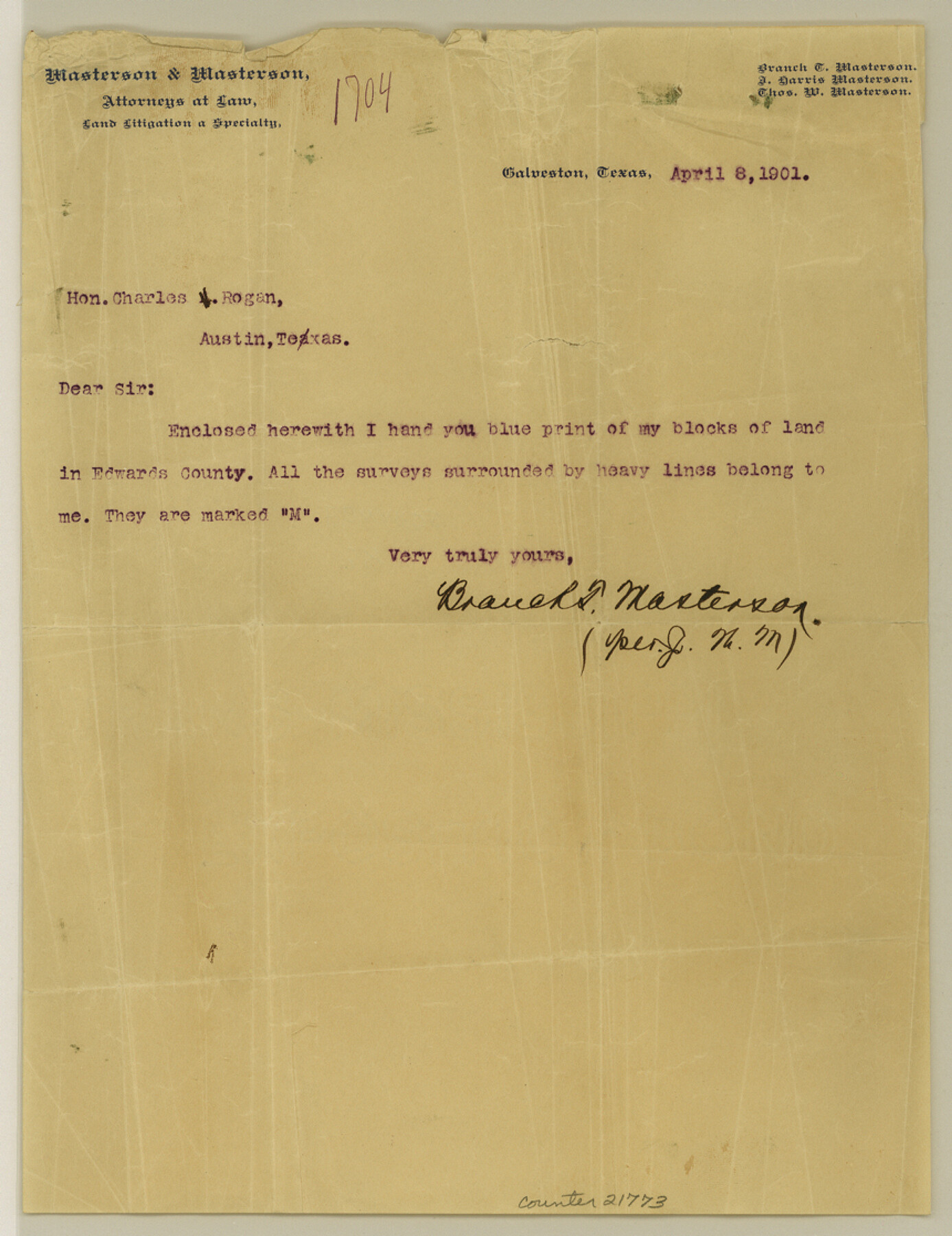
Edwards County Sketch File 38
Sketch Showing Land of Branch T. Masterson Edwards County, Texas
-
Map/Doc
21773
-
Collection
General Map Collection
-
Object Dates
1937/2/13 (Creation Date)
-
People and Organizations
Will H. Bonnell (Surveyor/Engineer)
-
Counties
Edwards
-
Subjects
Surveying Sketch File
-
Height x Width
11.2 x 8.6 inches
28.5 x 21.8 cm
-
Medium
multi-page, multi-format
-
Scale
1" = 2000 varas
Part of: General Map Collection
Duval County Sketch File 68

Print $20.00
- Digital $50.00
Duval County Sketch File 68
Size 23.9 x 19.6 inches
Map/Doc 11407
Panola County Working Sketch 14

Print $40.00
- Digital $50.00
Panola County Working Sketch 14
1945
Map/Doc 71423
Erath County Working Sketch 22

Print $20.00
- Digital $50.00
Erath County Working Sketch 22
1965
Size 29.8 x 36.8 inches
Map/Doc 69103
Fisher County Sketch File 9

Print $4.00
- Digital $50.00
Fisher County Sketch File 9
1893
Size 11.1 x 8.5 inches
Map/Doc 22575
Travis County Working Sketch 7

Print $2.00
- Digital $50.00
Travis County Working Sketch 7
1913
Size 10.9 x 8.2 inches
Map/Doc 69391
Flight Mission No. CGI-2N, Frame 180, Cameron County

Print $20.00
- Digital $50.00
Flight Mission No. CGI-2N, Frame 180, Cameron County
1954
Size 18.5 x 22.1 inches
Map/Doc 84540

Atascosa County Sketch File 34

Print $4.00
- Digital $50.00
Atascosa County Sketch File 34
Size 10.4 x 8.3 inches
Map/Doc 13827
Ector County Rolled Sketch 7

Print $20.00
- Digital $50.00
Ector County Rolled Sketch 7
1936
Size 37.1 x 30.4 inches
Map/Doc 5778
Mustang Island

Print $20.00
- Digital $50.00
Mustang Island
1908
Size 34.8 x 26.2 inches
Map/Doc 78670
Stieler Map of 1879

Print $4.00
- Digital $50.00
Stieler Map of 1879
1879
Size 28.8 x 23.0 inches
Map/Doc 76056
[Sketch for Mineral Application 16700 - Pecos River Bed]
![2807, [Sketch for Mineral Application 16700 - Pecos River Bed], General Map Collection](https://historictexasmaps.com/wmedia_w700/maps/2807.tif.jpg)
Print $20.00
- Digital $50.00
[Sketch for Mineral Application 16700 - Pecos River Bed]
1927
Size 32.9 x 15.3 inches
Map/Doc 2807
You may also like
Garza County Boundary File 3

Print $76.00
- Digital $50.00
Garza County Boundary File 3
Size 11.4 x 9.0 inches
Map/Doc 53683
County and Railroad Map of Texas

Print $20.00
- Digital $50.00
County and Railroad Map of Texas
1876
Size 17.0 x 16.0 inches
Map/Doc 93623
[Sketch Showing Blocks in Hansford County, Texas]
![75819, [Sketch Showing Blocks in Hansford County, Texas], Maddox Collection](https://historictexasmaps.com/wmedia_w700/maps/75819.tif.jpg)
Print $20.00
- Digital $50.00
[Sketch Showing Blocks in Hansford County, Texas]
1890
Size 34.1 x 25.3 inches
Map/Doc 75819
[Surveying Sketch of W.B. Tatum, Wm. B. Jordan, et al]
![428, [Surveying Sketch of W.B. Tatum, Wm. B. Jordan, et al], Maddox Collection](https://historictexasmaps.com/wmedia_w700/maps/0428.tif.jpg)
Print $2.00
- Digital $50.00
[Surveying Sketch of W.B. Tatum, Wm. B. Jordan, et al]
Size 8.9 x 10.8 inches
Map/Doc 428
Real County Rolled Sketch 18

Print $20.00
- Digital $50.00
Real County Rolled Sketch 18
Size 22.0 x 28.0 inches
Map/Doc 7466
Webb County Rolled Sketch 3

Print $20.00
- Digital $50.00
Webb County Rolled Sketch 3
1884
Size 19.7 x 24.8 inches
Map/Doc 8170
Burnet County Sketch File 41

Print $8.00
- Digital $50.00
Burnet County Sketch File 41
1950
Size 11.8 x 8.6 inches
Map/Doc 16757
[Surveys in the Bexar District along the Cibolo Creek]
![98, [Surveys in the Bexar District along the Cibolo Creek], General Map Collection](https://historictexasmaps.com/wmedia_w700/maps/98.tif.jpg)
Print $2.00
- Digital $50.00
[Surveys in the Bexar District along the Cibolo Creek]
1847
Size 13.0 x 7.4 inches
Map/Doc 98
Montgomery County Working Sketch 8b

Print $20.00
- Digital $50.00
Montgomery County Working Sketch 8b
1932
Size 17.7 x 20.7 inches
Map/Doc 71115
Sherman County Rolled Sketch 6

Print $20.00
- Digital $50.00
Sherman County Rolled Sketch 6
1919
Size 37.3 x 36.0 inches
Map/Doc 10731
Political Chief of Nacogdoches Correspondence with Various People (PCCVP)

Political Chief of Nacogdoches Correspondence with Various People (PCCVP)
Size 12.5 x 9.0 inches
Map/Doc 94264
[Jack District]
![16828, [Jack District], General Map Collection](https://historictexasmaps.com/wmedia_w700/maps/16828.tif.jpg)
Print $40.00
- Digital $50.00
[Jack District]
1876
Size 50.0 x 76.4 inches
Map/Doc 16828