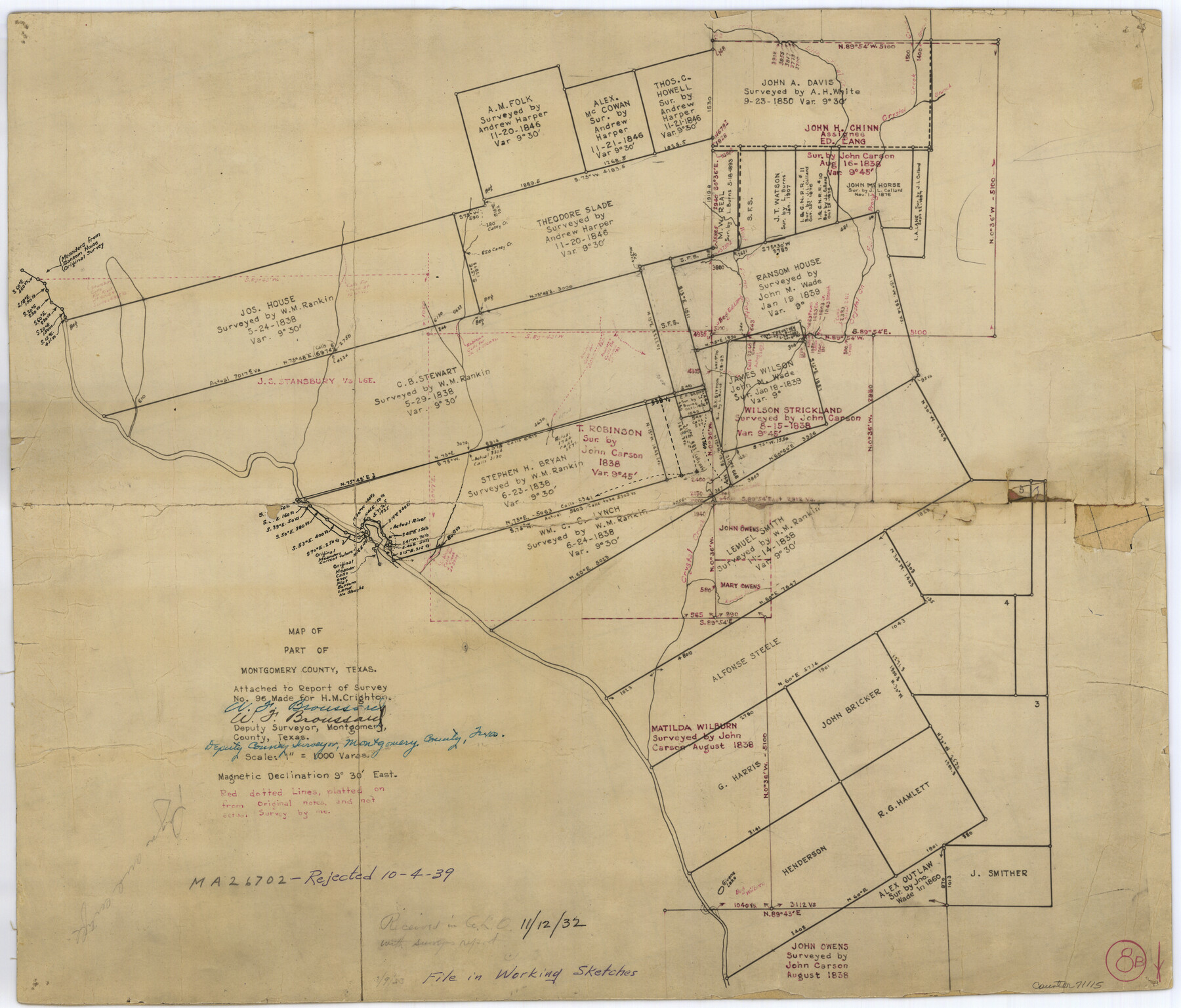
Montgomery County Working Sketch 8b
-
Map/Doc
71115
-
Collection
General Map Collection
-
Object Dates
11/12/1932 (Creation Date)
-
People and Organizations
W.F. Broussard (Surveyor/Engineer)
-
Counties
Montgomery
-
Subjects
Surveying Working Sketch
-
Height x Width
17.7 x 20.7 inches
45.0 x 52.6 cm
-
Scale
1" = 1000 varas
Part of: General Map Collection
El Paso County Boundary File 19

Print $9.00
- Digital $50.00
El Paso County Boundary File 19
Size 13.6 x 8.7 inches
Map/Doc 53206
Collin County Sketch File 15

Print $4.00
- Digital $50.00
Collin County Sketch File 15
1873
Size 10.0 x 8.0 inches
Map/Doc 18880
Chambers County NRC Article 33.136 Sketch 3

Print $21.00
- Digital $50.00
Chambers County NRC Article 33.136 Sketch 3
2005
Size 25.0 x 36.8 inches
Map/Doc 83595
[Neches River Bed, Plat and Calculations]
![77101, [Neches River Bed, Plat and Calculations], General Map Collection](https://historictexasmaps.com/wmedia_w700/maps/77101.tif.jpg)
Print $20.00
- Digital $50.00
[Neches River Bed, Plat and Calculations]
1928
Size 23.2 x 19.8 inches
Map/Doc 77101
Shelby County Working Sketch 33

Print $20.00
- Digital $50.00
Shelby County Working Sketch 33
2008
Size 23.6 x 27.5 inches
Map/Doc 88886
Red River County Working Sketch 26

Print $20.00
- Digital $50.00
Red River County Working Sketch 26
1961
Size 30.9 x 31.6 inches
Map/Doc 72009


Marion County Working Sketch 17

Print $20.00
- Digital $50.00
Marion County Working Sketch 17
1955
Size 31.1 x 26.1 inches
Map/Doc 70793
Copy of Surveyor's Field Book, Morris Browning - In Blocks 7, 5 & 4, I&GNRRCo., Hutchinson and Carson Counties, Texas

Print $2.00
- Digital $50.00
Copy of Surveyor's Field Book, Morris Browning - In Blocks 7, 5 & 4, I&GNRRCo., Hutchinson and Carson Counties, Texas
1888
Size 6.9 x 8.8 inches
Map/Doc 62262

Calhoun County Rolled Sketch 30

Print $20.00
- Digital $50.00
Calhoun County Rolled Sketch 30
1974
Size 18.5 x 27.6 inches
Map/Doc 5492
You may also like
Flight Mission No. BQR-12K, Frame 45, Brazoria County

Print $20.00
- Digital $50.00
Flight Mission No. BQR-12K, Frame 45, Brazoria County
1952
Size 18.8 x 22.5 inches
Map/Doc 84060
Ochiltree County Working Sketch 7

Print $40.00
- Digital $50.00
Ochiltree County Working Sketch 7
1968
Size 26.8 x 56.6 inches
Map/Doc 71320
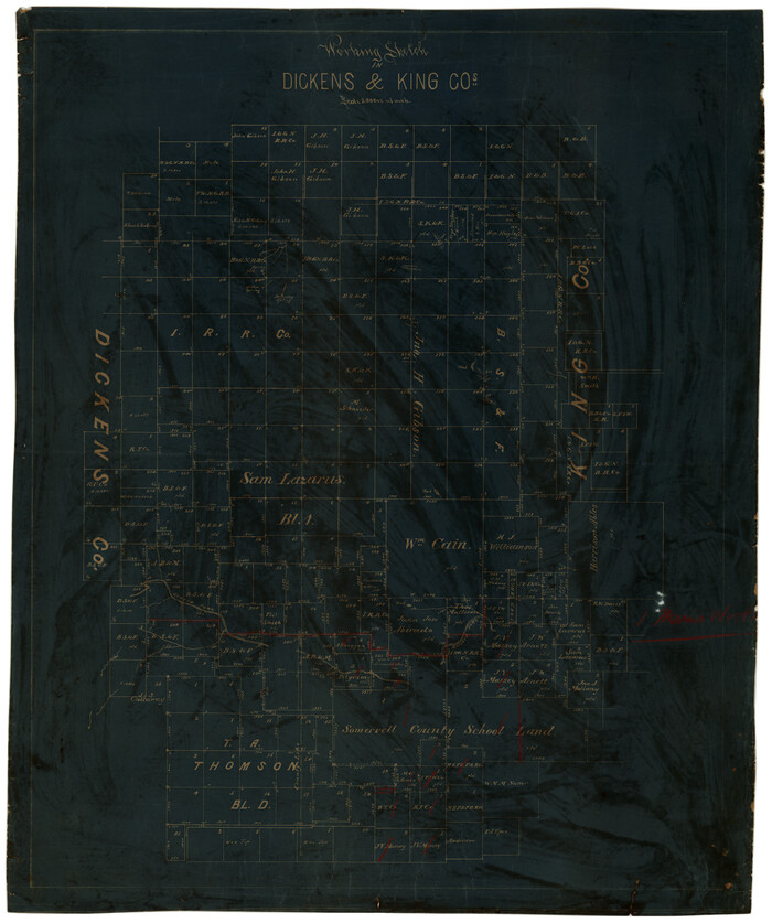
Working Sketch in Dickens & King Cos.
Print $20.00
- Digital $50.00
Working Sketch in Dickens & King Cos.
Size 24.4 x 20.4 inches
Map/Doc 10770
Duval County Sketch File 48

Print $8.00
- Digital $50.00
Duval County Sketch File 48
1935
Size 14.2 x 8.8 inches
Map/Doc 21405
Map of surveys made for the Texas & Pacific Railway Co. in Andrews & Tom Green Cos. Blocks 42, 43, 44, 45 & 46 reserve west of the Colorado River

Print $20.00
- Digital $50.00
Map of surveys made for the Texas & Pacific Railway Co. in Andrews & Tom Green Cos. Blocks 42, 43, 44, 45 & 46 reserve west of the Colorado River
1876
Size 42.3 x 37.6 inches
Map/Doc 2225
Brewster County Rolled Sketch 149

Print $20.00
- Digital $50.00
Brewster County Rolled Sketch 149
1951
Size 23.4 x 20.6 inches
Map/Doc 5316
Houston & Great Northern RR through Smith & other counties

Print $66.00
- Digital $50.00
Houston & Great Northern RR through Smith & other counties
1872
Size 14.2 x 8.4 inches
Map/Doc 64339
La Salle County Sketch File 10

Print $4.00
- Digital $50.00
La Salle County Sketch File 10
1877
Size 9.0 x 7.0 inches
Map/Doc 42997
Sketch in Floyd County

Print $20.00
- Digital $50.00
Sketch in Floyd County
1911
Size 25.3 x 41.8 inches
Map/Doc 90916
El Paso County Rolled Sketch 48

Print $20.00
- Digital $50.00
El Paso County Rolled Sketch 48
1960
Size 15.4 x 18.3 inches
Map/Doc 5834
Map of Chicago, Rock Island & Texas Railway through Tarrant County, Texas

Print $20.00
- Digital $50.00
Map of Chicago, Rock Island & Texas Railway through Tarrant County, Texas
1893
Size 20.7 x 35.7 inches
Map/Doc 64414
[Sketch showing Block M-20, Sections 9 through 46 and Block 22, Sections 1 through 12]
![91717, [Sketch showing Block M-20, Sections 9 through 46 and Block 22, Sections 1 through 12], Twichell Survey Records](https://historictexasmaps.com/wmedia_w700/maps/91717-1.tif.jpg)
Print $3.00
- Digital $50.00
[Sketch showing Block M-20, Sections 9 through 46 and Block 22, Sections 1 through 12]
Size 10.9 x 13.9 inches
Map/Doc 91717