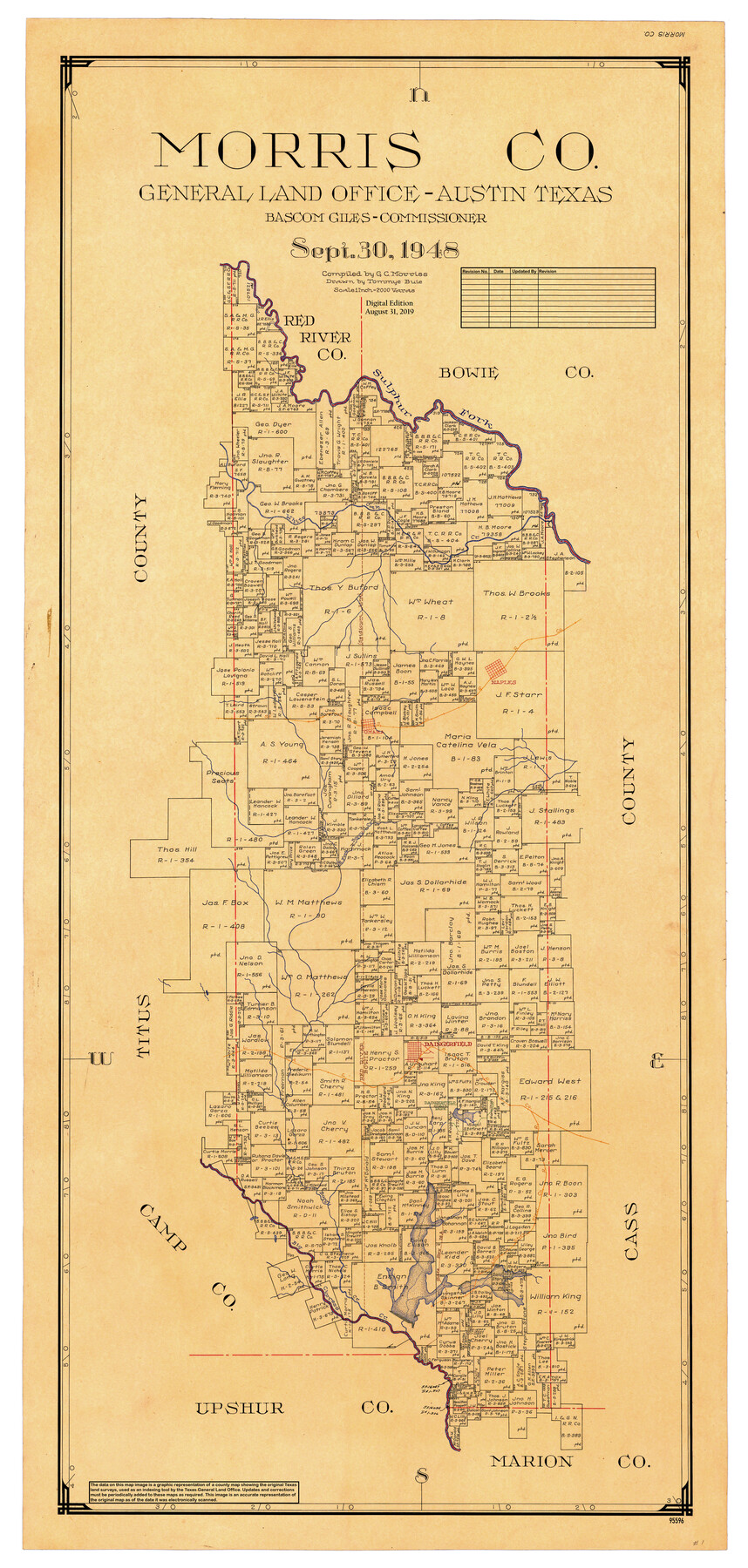
Morris Co.
General Land Office Official County Map
-
Map/Doc
95596
-
Collection
General Map Collection
-
Object Dates
9/30/1948 (Creation Date)
8/31/2019 (Revision Date)
-
People and Organizations
Bascom Giles (GLO Commissioner)
G.C. Morriss (Compiler)
Tommye Buie (Draftsman)
Cheyenne Betancourt (Draftsman)
-
Counties
Morris
-
Subjects
County OCM
-
Height x Width
45.1 x 21.5 inches
114.6 x 54.6 cm
-
Medium
digital image
-
Scale
1" = 2000 varas
Part of: General Map Collection
Geological Map of Texas

Print $20.00
- Digital $50.00
Geological Map of Texas
1919
Size 34.9 x 36.8 inches
Map/Doc 94091
Flight Mission No. DQN-4K, Frame 6, Calhoun County

Print $20.00
- Digital $50.00
Flight Mission No. DQN-4K, Frame 6, Calhoun County
1953
Size 18.6 x 22.4 inches
Map/Doc 84371
Val Verde County Working Sketch Graphic Index, Sheet 3 (Sketches 89 to Most Recent)

Print $20.00
- Digital $50.00
Val Verde County Working Sketch Graphic Index, Sheet 3 (Sketches 89 to Most Recent)
1944
Size 40.3 x 36.6 inches
Map/Doc 76726
Dawson County Working Sketch 22

Print $20.00
- Digital $50.00
Dawson County Working Sketch 22
1989
Size 26.2 x 20.5 inches
Map/Doc 68566
Nueces County Rolled Sketch 28

Print $20.00
- Digital $50.00
Nueces County Rolled Sketch 28
Size 16.8 x 25.1 inches
Map/Doc 6874
[Surveys along the Texas coast across from Mustang Island]
![346, [Surveys along the Texas coast across from Mustang Island], General Map Collection](https://historictexasmaps.com/wmedia_w700/maps/346.tif.jpg)
Print $2.00
- Digital $50.00
[Surveys along the Texas coast across from Mustang Island]
1841
Size 11.3 x 7.3 inches
Map/Doc 346
Flight Mission No. CGI-4N, Frame 186, Cameron County

Print $20.00
- Digital $50.00
Flight Mission No. CGI-4N, Frame 186, Cameron County
1955
Size 18.5 x 22.2 inches
Map/Doc 84689
Bell County Sketch File 1

Print $40.00
- Digital $50.00
Bell County Sketch File 1
1847
Size 14.7 x 12.4 inches
Map/Doc 14365
Jefferson County NRC Article 33.136 Sketch 13

Print $164.00
- Digital $50.00
Jefferson County NRC Article 33.136 Sketch 13
2019
Size 22.2 x 35.0 inches
Map/Doc 96447
Engineer's Office, Department of the Gulf Map No. 59, Texas prepared by order of Maj. Gen. N. P. Banks under direction of Capt. P. C. Hains, U. S. Engr. & Chief Engr., Dept. of the Gulf

Print $20.00
- Digital $50.00
Engineer's Office, Department of the Gulf Map No. 59, Texas prepared by order of Maj. Gen. N. P. Banks under direction of Capt. P. C. Hains, U. S. Engr. & Chief Engr., Dept. of the Gulf
1865
Size 18.2 x 27.5 inches
Map/Doc 72718
Runnels County Sketch File 38

Print $20.00
Runnels County Sketch File 38
1891
Size 17.6 x 24.9 inches
Map/Doc 12269
Winkler County Working Sketch 20

Print $20.00
- Digital $50.00
Winkler County Working Sketch 20
1990
Size 22.3 x 24.0 inches
Map/Doc 72614
You may also like
Sketch of a portion of the Texas Coast showing the relative positions of different harbours with the interior Military Posts, and the roads communicating with them, also two new routes from Black Point and Lamar to San Antonio

Print $20.00
- Digital $50.00
Sketch of a portion of the Texas Coast showing the relative positions of different harbours with the interior Military Posts, and the roads communicating with them, also two new routes from Black Point and Lamar to San Antonio
1855
Size 27.5 x 18.2 inches
Map/Doc 72708
Nueces County Rolled Sketch 103

Print $105.00
Nueces County Rolled Sketch 103
1985
Size 36.5 x 24.1 inches
Map/Doc 7078
Stonewall County Working Sketch 14

Print $20.00
- Digital $50.00
Stonewall County Working Sketch 14
1951
Size 22.2 x 37.1 inches
Map/Doc 62321
Flight Mission No. DQO-2K, Frame 142, Galveston County

Print $20.00
- Digital $50.00
Flight Mission No. DQO-2K, Frame 142, Galveston County
1952
Size 18.8 x 22.4 inches
Map/Doc 85039
Hardin County Working Sketch 42

Print $20.00
- Digital $50.00
Hardin County Working Sketch 42
1917
Size 16.2 x 22.1 inches
Map/Doc 63441
Hemphill County Sketch File 8

Print $9.00
- Digital $50.00
Hemphill County Sketch File 8
Size 14.3 x 8.9 inches
Map/Doc 26308
Wheeler County Working Sketch 15

Print $20.00
- Digital $50.00
Wheeler County Working Sketch 15
1981
Size 27.9 x 29.3 inches
Map/Doc 72504
[River Secs. 68-73, Archer County School Land League 3 and surrounding surveys]
![90468, [River Secs. 68-73, Archer County School Land League 3 and surrounding surveys], Twichell Survey Records](https://historictexasmaps.com/wmedia_w700/maps/90468-1.tif.jpg)
Print $20.00
- Digital $50.00
[River Secs. 68-73, Archer County School Land League 3 and surrounding surveys]
Size 38.4 x 36.4 inches
Map/Doc 90468
[G. & M. Block 5]
![91796, [G. & M. Block 5], Twichell Survey Records](https://historictexasmaps.com/wmedia_w700/maps/91796-1.tif.jpg)
Print $20.00
- Digital $50.00
[G. & M. Block 5]
Size 22.6 x 18.9 inches
Map/Doc 91796
Map of West Hickory Creek, Venango & Warren Cos., Pa.

Print $20.00
- Digital $50.00
Map of West Hickory Creek, Venango & Warren Cos., Pa.
1866
Size 45.7 x 24.7 inches
Map/Doc 94056
Schleicher County Rolled Sketch 2

Print $20.00
- Digital $50.00
Schleicher County Rolled Sketch 2
1888
Size 25.8 x 32.6 inches
Map/Doc 7746
Hays County Boundary File 1

Print $14.00
- Digital $50.00
Hays County Boundary File 1
Size 9.5 x 5.2 inches
Map/Doc 54586