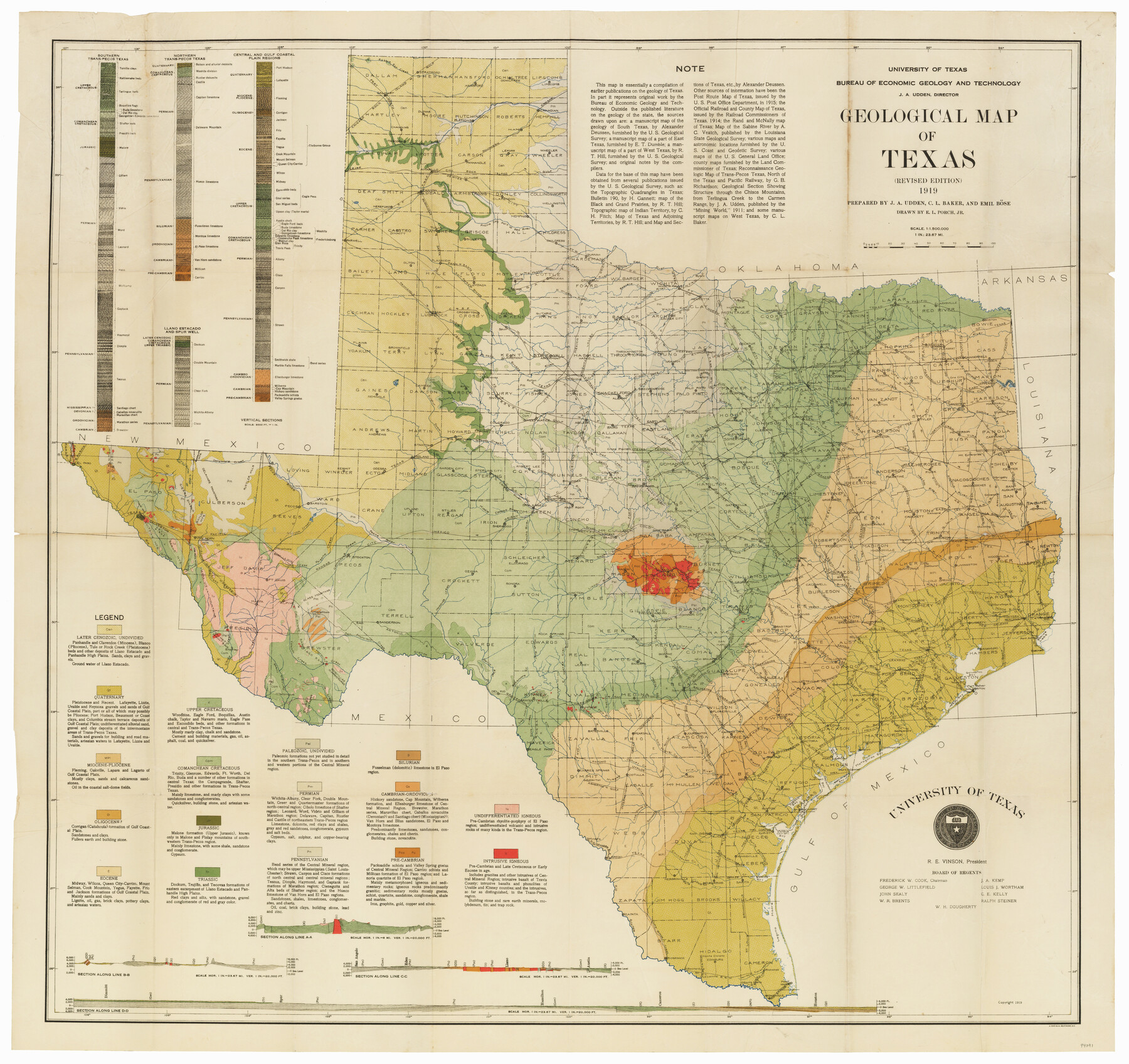
Geological Map of Texas
(Revised Edition)
-
Map/Doc
94091
-
Collection
General Map Collection
-
Object Dates
1919 (Creation Date)
-
People and Organizations
University of Texas, Bureau of Economic Geology (Publisher)
J.A. Udden (Author)
C.L. Baker (Author)
Emil Böse (Author)
E.L. Porch Jr. (Draftsman)
-
Subjects
State of Texas
-
Height x Width
34.9 x 36.8 inches
88.7 x 93.5 cm
-
Medium
paper, etching/engraving/lithograph
-
Scale
1 in = 23.67 miles
Part of: General Map Collection
Angelina County

Print $40.00
- Digital $50.00
Angelina County
1945
Size 39.0 x 48.4 inches
Map/Doc 73068
Nueva Hispania Tabula Nova

Print $20.00
- Digital $50.00
Nueva Hispania Tabula Nova
1561
Size 9.4 x 12.3 inches
Map/Doc 93796
[Texas Gulf Coast from Rio Grande to Sabine Lake]
![72687, [Texas Gulf Coast from Rio Grande to Sabine Lake], General Map Collection](https://historictexasmaps.com/wmedia_w700/maps/72687.tif.jpg)
Print $20.00
- Digital $50.00
[Texas Gulf Coast from Rio Grande to Sabine Lake]
Size 28.1 x 18.3 inches
Map/Doc 72687
Menard County Working Sketch 23

Print $20.00
- Digital $50.00
Menard County Working Sketch 23
1950
Size 45.1 x 41.3 inches
Map/Doc 70970
Gonzales County Working Sketch 4a

Print $20.00
- Digital $50.00
Gonzales County Working Sketch 4a
1979
Size 30.9 x 32.2 inches
Map/Doc 63219

Nacogdoches County Rolled Sketch 2

Print $20.00
- Digital $50.00
Nacogdoches County Rolled Sketch 2
1949
Size 44.3 x 42.3 inches
Map/Doc 46837
Dawson County Working Sketch 10

Print $20.00
- Digital $50.00
Dawson County Working Sketch 10
1944
Size 15.6 x 13.6 inches
Map/Doc 68554
Segunda parte del Mapa, que comprende la Frontera, de los Dominios del Rey, en la America Septentrional

Print $40.00
- Digital $50.00
Segunda parte del Mapa, que comprende la Frontera, de los Dominios del Rey, en la America Septentrional
1769
Size 26.7 x 63.8 inches
Map/Doc 4667
Presidio County Working Sketch 62

Print $3.00
- Digital $50.00
Presidio County Working Sketch 62
1958
Size 12.6 x 9.5 inches
Map/Doc 71739
McMullen County Rolled Sketch 18

Print $20.00
- Digital $50.00
McMullen County Rolled Sketch 18
Size 18.8 x 27.5 inches
Map/Doc 6734
Cameron County Rolled Sketch 27

Print $20.00
- Digital $50.00
Cameron County Rolled Sketch 27
Size 19.0 x 39.5 inches
Map/Doc 5392
You may also like
Blanco County Boundary File 1

Print $20.00
- Digital $50.00
Blanco County Boundary File 1
Size 11.6 x 23.1 inches
Map/Doc 50539
Frio County Working Sketch 11

Print $20.00
- Digital $50.00
Frio County Working Sketch 11
1952
Size 22.9 x 20.0 inches
Map/Doc 69285
Hardin County Working Sketch 22

Print $20.00
- Digital $50.00
Hardin County Working Sketch 22
1948
Size 20.9 x 31.6 inches
Map/Doc 63420
Taylor County Working Sketch 11

Print $20.00
- Digital $50.00
Taylor County Working Sketch 11
1956
Size 23.0 x 24.4 inches
Map/Doc 69621
Gonzales County Working Sketch 14

Print $20.00
- Digital $50.00
Gonzales County Working Sketch 14
1981
Size 18.3 x 20.9 inches
Map/Doc 63230
Flight Mission No. CGI-3N, Frame 134, Cameron County

Print $20.00
- Digital $50.00
Flight Mission No. CGI-3N, Frame 134, Cameron County
1954
Size 18.4 x 22.2 inches
Map/Doc 84607

Culberson County Working Sketch 45

Print $20.00
- Digital $50.00
Culberson County Working Sketch 45
1971
Size 24.4 x 37.1 inches
Map/Doc 68499
Harris County Sketch File 104

Print $2.00
- Digital $50.00
Harris County Sketch File 104
1992
Size 11.2 x 8.9 inches
Map/Doc 25974
Jackson County

Print $40.00
- Digital $50.00
Jackson County
1920
Size 49.5 x 41.8 inches
Map/Doc 66878
Val Verde County Sketch File 55

Print $44.00
- Digital $50.00
Val Verde County Sketch File 55
1999
Size 11.5 x 8.9 inches
Map/Doc 39337
Lampasas County Working Sketch 5

Print $20.00
- Digital $50.00
Lampasas County Working Sketch 5
1947
Size 25.6 x 31.8 inches
Map/Doc 70282