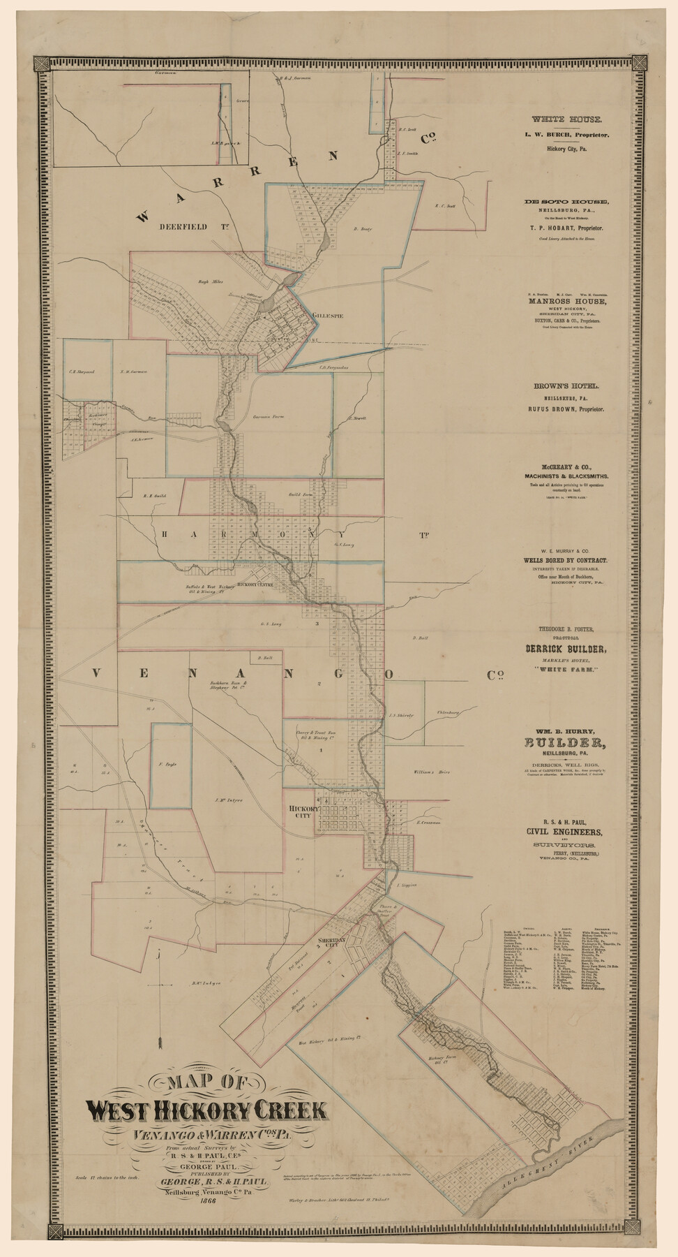
Map of West Hickory Creek, Venango & Warren Cos., Pa.
-
Map/Doc
94056
-
Collection
Rees-Jones Digital Map Collection
-
Object Dates
1866 (Creation Date)
-
People and Organizations
George, R.S. & H. Paul (Publisher)
Worley & Bracher (Printer)
George Paul (Draftsman)
R.S. Paul (Surveyor/Engineer)
H. Paul (Surveyor/Engineer)
-
Height x Width
45.7 x 24.7 inches
116.1 x 62.7 cm
-
Medium
digital image
-
Scale
12 chains to the inch
-
Comments
Courtesy of the Rees-Jones Collection, Dallas, TX
Part of: Rees-Jones Digital Map Collection
A New Map of Texas with the Contiguous American & Mexican States

Print $20.00
- Digital $50.00
A New Map of Texas with the Contiguous American & Mexican States
1839
Size 13.5 x 16.1 inches
Map/Doc 93941
Colton's new map of the State of Texas, the Indian Territory and adjoining portions of New Mexico, Louisiana and Arkansas

Print $20.00
- Digital $50.00
Colton's new map of the State of Texas, the Indian Territory and adjoining portions of New Mexico, Louisiana and Arkansas
1874
Size 34.7 x 38.7 inches
Map/Doc 93762
Map of Texas, compiled from surveys on record in the General Land Office of the Republic to the year 1839

Print $20.00
- Digital $50.00
Map of Texas, compiled from surveys on record in the General Land Office of the Republic to the year 1839
1839
Size 33.1 x 25.8 inches
Map/Doc 93986
A. R. Roessler's Latest Map of the State of Texas Exhibiting Mineral and Agricultural Districts, Post Offices and Mailroutes, Railroads projected and finished, Timber, Prairie, Swamp Lands, etc. etc. etc.

Print $20.00
- Digital $50.00
A. R. Roessler's Latest Map of the State of Texas Exhibiting Mineral and Agricultural Districts, Post Offices and Mailroutes, Railroads projected and finished, Timber, Prairie, Swamp Lands, etc. etc. etc.
1874
Size 40.8 x 47.4 inches
Map/Doc 93934
Minnesota Route the shortest and best to the Idaho Gold Mines

Print $20.00
- Digital $50.00
Minnesota Route the shortest and best to the Idaho Gold Mines
Size 21.0 x 46.3 inches
Map/Doc 93989
Chart of the Antarctic Continent shewing the icy barrier attached to it discovered by the U.S. Ex. Ex.

Print $20.00
- Digital $50.00
Chart of the Antarctic Continent shewing the icy barrier attached to it discovered by the U.S. Ex. Ex.
1840
Size 26.5 x 37.2 inches
Map/Doc 94059
Map of Arizona prepared specially for R.J. Hinton's handbook of Arizona

Print $20.00
- Digital $50.00
Map of Arizona prepared specially for R.J. Hinton's handbook of Arizona
1877
Size 36.4 x 25.7 inches
Map/Doc 94062
Colton's Map of United States, the Canadas & c. showing the Railraods, Canals & Stage Roads with distances from place to place

Print $20.00
- Digital $50.00
Colton's Map of United States, the Canadas & c. showing the Railraods, Canals & Stage Roads with distances from place to place
Size 28.8 x 33.0 inches
Map/Doc 93983
A Map of the United States of Mexico as organized and defined by the several Acts of the Congress of that Republic

Print $20.00
- Digital $50.00
A Map of the United States of Mexico as organized and defined by the several Acts of the Congress of that Republic
1826
Size 23.9 x 31.2 inches
Map/Doc 93939
Map of Texas With Parts of the Adjoining States

Print $20.00
- Digital $50.00
Map of Texas With Parts of the Adjoining States
1836
Size 30.9 x 24.8 inches
Map/Doc 93932
Nebraska and Kansas

Print $20.00
- Digital $50.00
Nebraska and Kansas
Size 14.7 x 16.7 inches
Map/Doc 93997
The Rand-McNally New Commercial Atlas Map of Texas

Print $20.00
- Digital $50.00
The Rand-McNally New Commercial Atlas Map of Texas
Size 29.5 x 40.3 inches
Map/Doc 93993
You may also like
[H. & T. C. Blocks 1 and 2]
![91049, [H. & T. C. Blocks 1 and 2], Twichell Survey Records](https://historictexasmaps.com/wmedia_w700/maps/91049-1.tif.jpg)
Print $3.00
- Digital $50.00
[H. & T. C. Blocks 1 and 2]
Size 13.3 x 11.7 inches
Map/Doc 91049
Lampasas County Working Sketch 20

Print $20.00
- Digital $50.00
Lampasas County Working Sketch 20
1981
Size 26.0 x 31.9 inches
Map/Doc 70297
The Republic County of Harrison. January 8, 1844

Print $20.00
The Republic County of Harrison. January 8, 1844
2020
Size 18.6 x 21.7 inches
Map/Doc 96175
Mason County Boundary File 5

Print $20.00
- Digital $50.00
Mason County Boundary File 5
Size 9.7 x 7.0 inches
Map/Doc 56862
Randall County Sketch File 9

Print $22.00
- Digital $50.00
Randall County Sketch File 9
Size 13.9 x 17.0 inches
Map/Doc 34970
Wood County Working Sketch 11

Print $20.00
- Digital $50.00
Wood County Working Sketch 11
1964
Size 31.4 x 37.4 inches
Map/Doc 62011
Comanche County Sketch File 15

Print $4.00
- Digital $50.00
Comanche County Sketch File 15
Size 8.3 x 12.9 inches
Map/Doc 19080
Ward County Boundary File 1

Print $12.00
- Digital $50.00
Ward County Boundary File 1
Size 14.4 x 9.0 inches
Map/Doc 59667
Genl. Austins Map of Texas With Parts of the Adjoining States

Print $20.00
Genl. Austins Map of Texas With Parts of the Adjoining States
1840
Size 30.1 x 24.5 inches
Map/Doc 79293
Map and Profile No. 1 from the Red River to the Rio Grande; from Explorations and surveys made under the direction of the Hon. Jeffeson Davis, Secretary of War

Print $40.00
- Digital $50.00
Map and Profile No. 1 from the Red River to the Rio Grande; from Explorations and surveys made under the direction of the Hon. Jeffeson Davis, Secretary of War
1856
Size 30.5 x 57.0 inches
Map/Doc 4330
Live Oak County Sketch File 15

Print $4.00
- Digital $50.00
Live Oak County Sketch File 15
Size 12.6 x 8.1 inches
Map/Doc 30280
Map of Nacogdoches County

Print $40.00
- Digital $50.00
Map of Nacogdoches County
1839
Size 83.6 x 43.2 inches
Map/Doc 93370