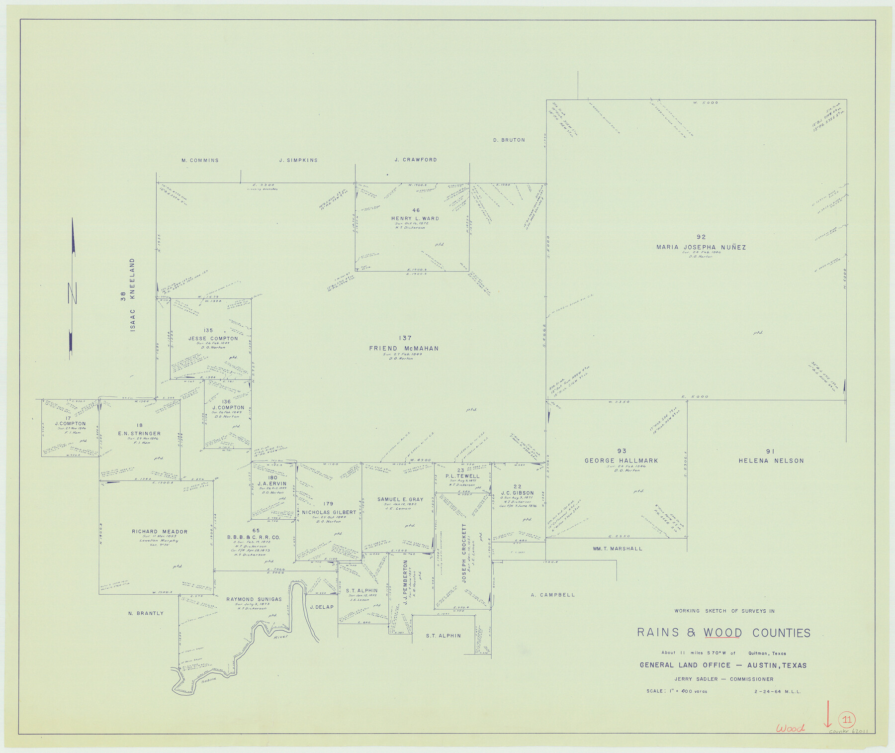
Wood County Working Sketch 11
-
Map/Doc
62011
-
Collection
General Map Collection
-
Object Dates
2/24/1964 (Creation Date)
-
People and Organizations
M. L. Liles (Draftsman)
-
Counties
Wood Rains
-
Subjects
Surveying Working Sketch
-
Height x Width
31.4 x 37.4 inches
79.8 x 95.0 cm
-
Scale
1" = 400 varas
Part of: General Map Collection
Grayson County

Print $20.00
- Digital $50.00
Grayson County
1935
Size 43.4 x 40.5 inches
Map/Doc 95512
A Map of the British Empire in North America

Print $20.00
- Digital $50.00
A Map of the British Empire in North America
1774
Size 22.1 x 15.1 inches
Map/Doc 93733
Colorado River, Lane City Sheet

Print $4.00
- Digital $50.00
Colorado River, Lane City Sheet
1941
Size 27.0 x 29.9 inches
Map/Doc 65316
Brazoria County Sketch File 15b

Print $40.00
- Digital $50.00
Brazoria County Sketch File 15b
Size 13.2 x 26.3 inches
Map/Doc 10951
Calhoun County Rolled Sketch 20

Print $20.00
- Digital $50.00
Calhoun County Rolled Sketch 20
1959
Size 36.9 x 20.7 inches
Map/Doc 5372
Nueces County Rolled Sketch 47

Print $20.00
- Digital $50.00
Nueces County Rolled Sketch 47
1953
Size 31.3 x 44.6 inches
Map/Doc 6886
Jackson County Sketch File 6a

Print $30.00
- Digital $50.00
Jackson County Sketch File 6a
1894
Size 13.6 x 8.8 inches
Map/Doc 27634
Sabine County Working Sketch 4

Print $20.00
- Digital $50.00
Sabine County Working Sketch 4
1913
Size 23.7 x 32.0 inches
Map/Doc 63675
Controlled Mosaic by Jack Amman Photogrammetric Engineers, Inc - Sheet 25

Print $20.00
- Digital $50.00
Controlled Mosaic by Jack Amman Photogrammetric Engineers, Inc - Sheet 25
1954
Size 20.0 x 24.0 inches
Map/Doc 83476
Right of Way and Track Map, International & Gt. Northern Ry. Operated by the International & Gt. Northern Ry. Co., Gulf Division

Print $40.00
- Digital $50.00
Right of Way and Track Map, International & Gt. Northern Ry. Operated by the International & Gt. Northern Ry. Co., Gulf Division
1917
Size 25.0 x 56.5 inches
Map/Doc 64248
Swisher County Sketch File 3

Print $20.00
- Digital $50.00
Swisher County Sketch File 3
1896
Size 17.2 x 16.1 inches
Map/Doc 12403
Coleman County Working Sketch Graphic Index

Print $40.00
- Digital $50.00
Coleman County Working Sketch Graphic Index
1945
Size 54.0 x 36.3 inches
Map/Doc 76497
You may also like

Upton County Rolled Sketch 51

Print $20.00
- Digital $50.00
Upton County Rolled Sketch 51
1961
Size 34.0 x 29.8 inches
Map/Doc 8086
Packery Channel

Print $20.00
- Digital $50.00
Packery Channel
1954
Size 16.7 x 19.9 inches
Map/Doc 3002
Chambers County Rolled Sketch 23

Print $40.00
- Digital $50.00
Chambers County Rolled Sketch 23
1940
Size 36.5 x 49.2 inches
Map/Doc 8591
Aransas Pass to Baffin Bay

Print $20.00
- Digital $50.00
Aransas Pass to Baffin Bay
1949
Size 42.6 x 34.7 inches
Map/Doc 73413
Reeves County Boundary File 1

Print $12.00
- Digital $50.00
Reeves County Boundary File 1
Size 14.1 x 8.5 inches
Map/Doc 58195
Map Showing Eastern Portion of Pecos County, Texas

Print $40.00
- Digital $50.00
Map Showing Eastern Portion of Pecos County, Texas
Size 62.2 x 43.5 inches
Map/Doc 89835
Agua Fria Quadrangle

Print $20.00
- Digital $50.00
Agua Fria Quadrangle
1917
Size 17.2 x 21.1 inches
Map/Doc 90136

Flight Mission No. DQO-3K, Frame 27, Galveston County

Print $20.00
- Digital $50.00
Flight Mission No. DQO-3K, Frame 27, Galveston County
1952
Size 18.7 x 22.5 inches
Map/Doc 85068
Schleicher County Sketch File 37

Print $20.00
- Digital $50.00
Schleicher County Sketch File 37
1952
Size 24.9 x 29.3 inches
Map/Doc 12310
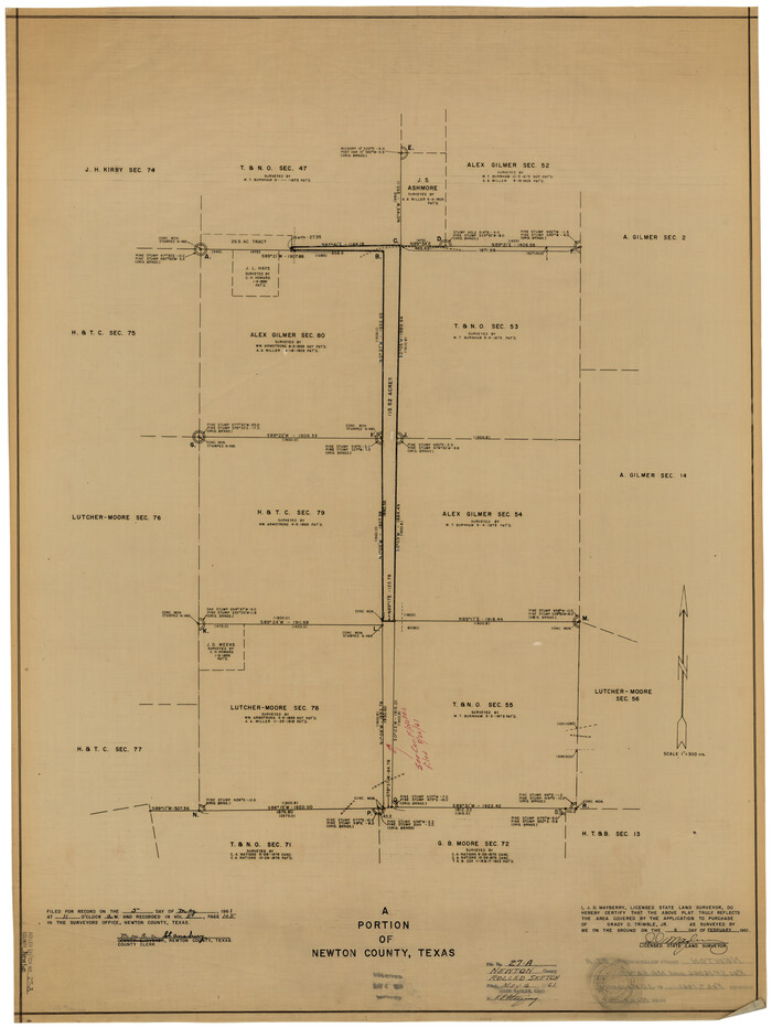
Newton County Rolled Sketch 27A
Print $20.00
- Digital $50.00
Newton County Rolled Sketch 27A
1961
Size 35.9 x 27.1 inches
Map/Doc 6857