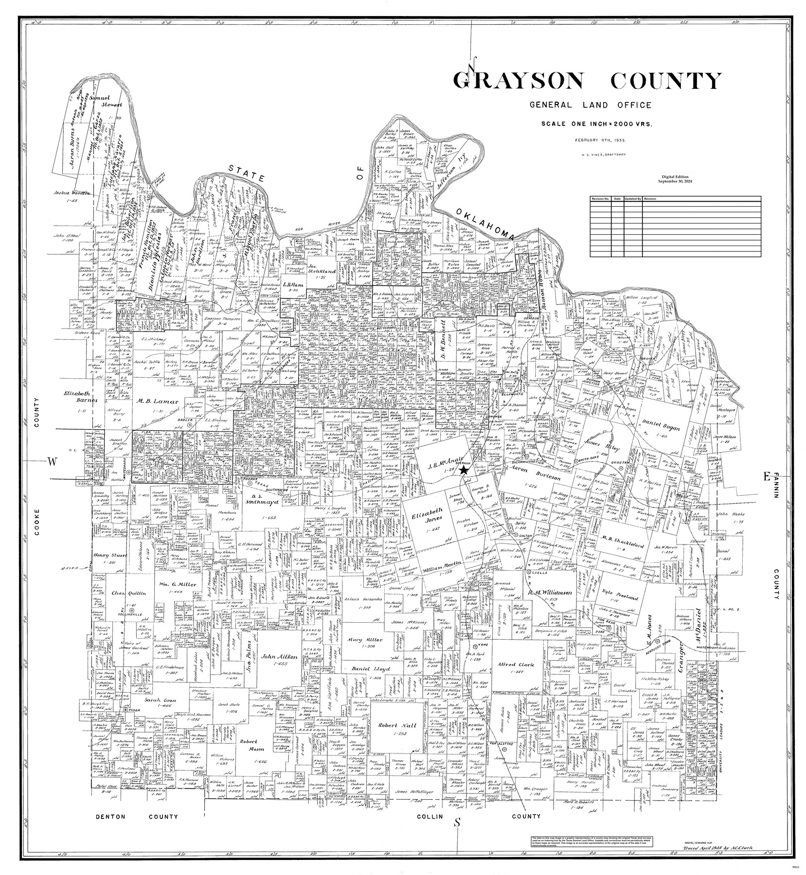
Grayson County
General Land Office Official County Map
-
Map/Doc
95512
-
Collection
General Map Collection
-
Object Dates
2/8/1935 (Creation Date)
9/30/2024 (Revision Date)
-
People and Organizations
W.S. Vines (Draftsman)
Cheyenne Betancourt (Draftsman)
-
Counties
Grayson
-
Subjects
County OCM
-
Height x Width
43.4 x 40.5 inches
110.2 x 102.9 cm
-
Medium
digital image
-
Scale
1" = 2000 varas
Part of: General Map Collection
Limestone County Sketch File 27

Print $20.00
- Digital $50.00
Limestone County Sketch File 27
Size 23.2 x 18.8 inches
Map/Doc 12004
Starr County Working Sketch 25

Print $20.00
- Digital $50.00
Starr County Working Sketch 25
1988
Size 38.5 x 27.9 inches
Map/Doc 63941
Kerr County Rolled Sketch 21

Print $20.00
- Digital $50.00
Kerr County Rolled Sketch 21
1959
Size 44.5 x 30.5 inches
Map/Doc 9348
Ochiltree County Working Sketch 9

Print $20.00
- Digital $50.00
Ochiltree County Working Sketch 9
1990
Size 37.1 x 37.4 inches
Map/Doc 71322
Terrell County Working Sketch 24

Print $20.00
- Digital $50.00
Terrell County Working Sketch 24
1942
Size 16.2 x 41.3 inches
Map/Doc 62174
Gregg County Rolled Sketch 13

Print $64.00
- Digital $50.00
Gregg County Rolled Sketch 13
1940
Size 10.5 x 15.5 inches
Map/Doc 45439
Johnson County

Print $20.00
- Digital $50.00
Johnson County
1943
Size 42.4 x 39.0 inches
Map/Doc 1868
Upton County Sketch File 31

Print $20.00
- Digital $50.00
Upton County Sketch File 31
Size 5.8 x 20.7 inches
Map/Doc 38883
Williamson County Rolled Sketch 10

Print $20.00
- Digital $50.00
Williamson County Rolled Sketch 10
1975
Size 24.8 x 19.2 inches
Map/Doc 8267
San Patricio County Sketch File 40

Print $4.00
- Digital $50.00
San Patricio County Sketch File 40
1842
Size 10.5 x 8.2 inches
Map/Doc 36236
Crockett County Rolled Sketch E

Print $20.00
- Digital $50.00
Crockett County Rolled Sketch E
1907
Size 26.2 x 27.7 inches
Map/Doc 5636
Flight Mission No. CRC-2R, Frame 189, Chambers County

Print $20.00
- Digital $50.00
Flight Mission No. CRC-2R, Frame 189, Chambers County
1956
Size 18.6 x 22.4 inches
Map/Doc 84767
You may also like
City of Corpus Christi, Texas

Print $20.00
- Digital $50.00
City of Corpus Christi, Texas
1969
Size 22.6 x 51.0 inches
Map/Doc 96520

Brown County Working Sketch 7

Print $20.00
- Digital $50.00
Brown County Working Sketch 7
1954
Size 26.5 x 28.7 inches
Map/Doc 67772
Carta Agricola

Print $20.00
- Digital $50.00
Carta Agricola
1897
Size 26.0 x 34.3 inches
Map/Doc 96804
Ellis County Sketch File 6

Print $24.00
- Digital $50.00
Ellis County Sketch File 6
Size 12.3 x 8.2 inches
Map/Doc 21836
Harris County State Real Property Sketch 2

Print $32.00
- Digital $50.00
Harris County State Real Property Sketch 2
1999
Size 30.2 x 42.4 inches
Map/Doc 61702
Lynn County Sketch File 17

Print $20.00
- Digital $50.00
Lynn County Sketch File 17
Size 13.2 x 20.9 inches
Map/Doc 12020
General Highway Map, Atascosa County, Texas

Print $20.00
General Highway Map, Atascosa County, Texas
1961
Size 18.3 x 24.9 inches
Map/Doc 79356
Waller County Sketch File 12

Print $6.00
- Digital $50.00
Waller County Sketch File 12
1928
Size 7.6 x 8.8 inches
Map/Doc 39616
Erath County Working Sketch 11

Print $20.00
- Digital $50.00
Erath County Working Sketch 11
1951
Size 45.1 x 36.2 inches
Map/Doc 69092
[Township 3 North, Block 32]
![91218, [Township 3 North, Block 32], Twichell Survey Records](https://historictexasmaps.com/wmedia_w700/maps/91218-1.tif.jpg)
Print $20.00
- Digital $50.00
[Township 3 North, Block 32]
Size 14.4 x 17.8 inches
Map/Doc 91218
Crockett County Rolled Sketch 3

Print $20.00
- Digital $50.00
Crockett County Rolled Sketch 3
1886
Size 18.1 x 22.9 inches
Map/Doc 5579