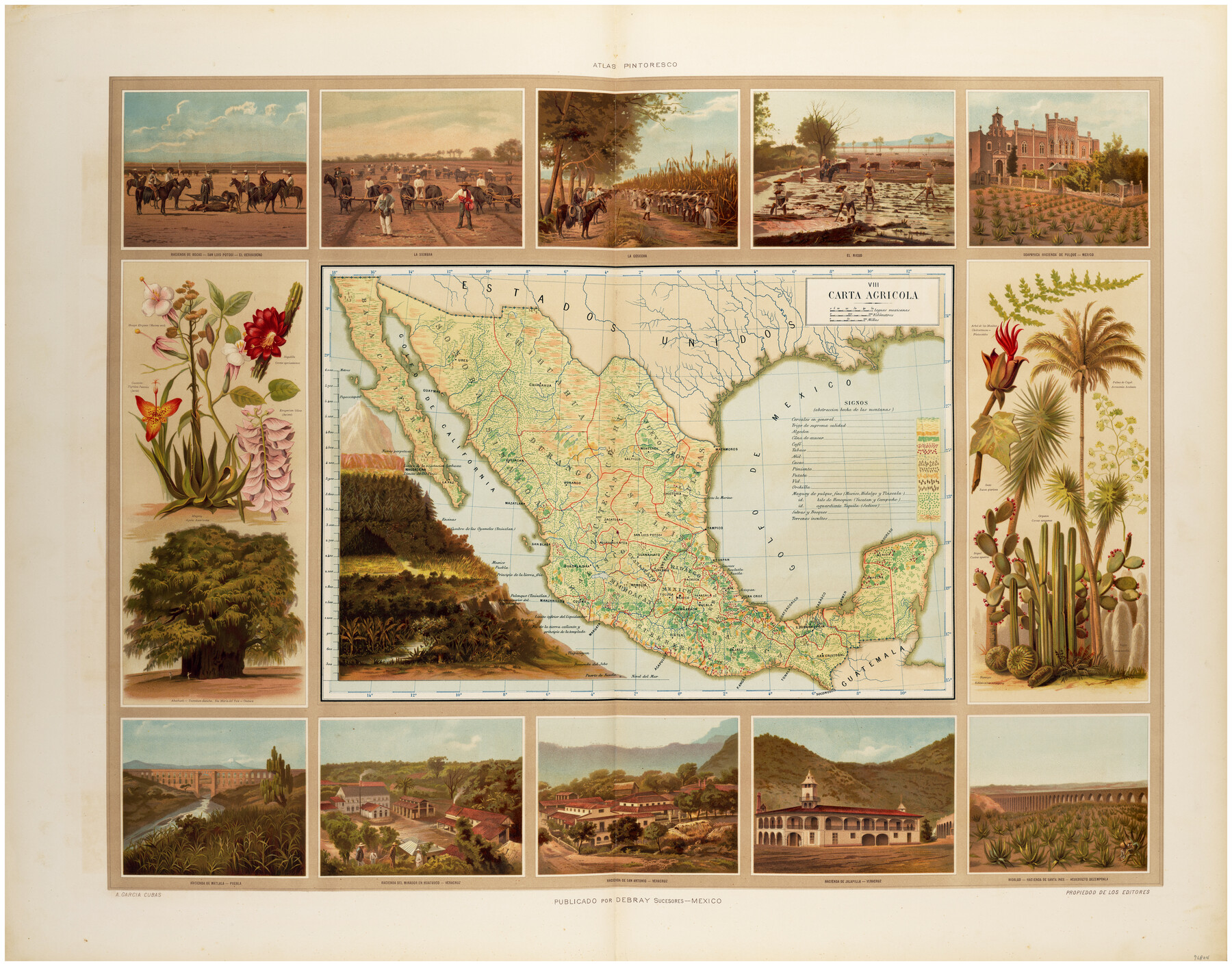
Carta Agricola
-
Map/Doc
96804
-
Collection
General Map Collection
-
Object Dates
1897 (Creation Date)
-
People and Organizations
Debray Sucesores (Publisher)
Antonio Garcia Cubas (Cartographer)
-
Subjects
Atlas Mexico
-
Height x Width
26.0 x 34.3 inches
66.0 x 87.1 cm
-
Medium
paper, etching/engraving/lithograph
-
Comments
Map 8 of 13 from "Atlas Pintoresco e Historico de los Estados Unidos Mexicanos" (96796 - PDF)
Related maps
Atlas Pintoresco e Historico de los Estados Unidos Mexicanos

Atlas Pintoresco e Historico de los Estados Unidos Mexicanos
Map/Doc 96796
Part of: General Map Collection
Lavaca County Working Sketch 22

Print $20.00
- Digital $50.00
Lavaca County Working Sketch 22
1983
Size 39.6 x 36.4 inches
Map/Doc 70375
Stephens County Sketch File 20

Print $20.00
- Digital $50.00
Stephens County Sketch File 20
Size 19.2 x 36.7 inches
Map/Doc 12350

Austin County

Print $20.00
- Digital $50.00
Austin County
1943
Size 40.2 x 43.0 inches
Map/Doc 95422
Llano County Sketch File 3

Print $6.00
- Digital $50.00
Llano County Sketch File 3
1874
Size 8.0 x 8.9 inches
Map/Doc 30350
Kendall County Rolled Sketch 9

Print $20.00
- Digital $50.00
Kendall County Rolled Sketch 9
1990
Size 32.8 x 24.3 inches
Map/Doc 95298
Flight Mission No. DCL-6C, Frame 29, Kenedy County

Print $20.00
- Digital $50.00
Flight Mission No. DCL-6C, Frame 29, Kenedy County
1943
Size 18.6 x 22.4 inches
Map/Doc 85886
Flight Mission No. DAG-21K, Frame 127, Matagorda County

Print $20.00
- Digital $50.00
Flight Mission No. DAG-21K, Frame 127, Matagorda County
1952
Size 18.5 x 22.4 inches
Map/Doc 86453

Real County Sketch File 11

Print $8.00
- Digital $50.00
Real County Sketch File 11
1932
Size 11.2 x 8.8 inches
Map/Doc 35065
Jeff Davis County Boundary File 1a

Print $8.00
- Digital $50.00
Jeff Davis County Boundary File 1a
Size 14.3 x 8.8 inches
Map/Doc 55501
Blanco County Working Sketch 19

Print $20.00
- Digital $50.00
Blanco County Working Sketch 19
1960
Size 24.4 x 29.2 inches
Map/Doc 67379
You may also like
[Blocks M-21, Z, and E. L. & RR. Block L]
![91151, [Blocks M-21, Z, and E. L. & RR. Block L], Twichell Survey Records](https://historictexasmaps.com/wmedia_w700/maps/91151-1.tif.jpg)
Print $20.00
- Digital $50.00
[Blocks M-21, Z, and E. L. & RR. Block L]
Size 14.5 x 17.9 inches
Map/Doc 91151

Harris County Working Sketch 91

Print $20.00
- Digital $50.00
Harris County Working Sketch 91
1973
Size 44.6 x 36.9 inches
Map/Doc 65983
Flight Mission No. DQO-2K, Frame 102, Galveston County

Print $20.00
- Digital $50.00
Flight Mission No. DQO-2K, Frame 102, Galveston County
1952
Size 18.8 x 22.5 inches
Map/Doc 85029
Uvalde County Working Sketch 66

Print $20.00
- Digital $50.00
Uvalde County Working Sketch 66
1942
Size 20.9 x 21.3 inches
Map/Doc 75968
Callahan County Rolled Sketch 4

Print $20.00
- Digital $50.00
Callahan County Rolled Sketch 4
1952
Size 20.8 x 30.6 inches
Map/Doc 5381
Howard McCauley Irrigated Farm North Half Section 2, Block D4

Print $20.00
- Digital $50.00
Howard McCauley Irrigated Farm North Half Section 2, Block D4
1946
Size 32.0 x 19.4 inches
Map/Doc 92342
Index to Titles, Field Notes, and Plats in the Spanish Archives

Index to Titles, Field Notes, and Plats in the Spanish Archives
1942
Size 17.5 x 10.1 inches
Map/Doc 94524
Flight Mission No. CUG-1P, Frame 80, Kleberg County

Print $20.00
- Digital $50.00
Flight Mission No. CUG-1P, Frame 80, Kleberg County
1956
Size 18.8 x 22.4 inches
Map/Doc 86145
Brazoria County Working Sketch 16

Print $20.00
- Digital $50.00
Brazoria County Working Sketch 16
1943
Size 35.3 x 32.3 inches
Map/Doc 67501
Plat of Location and Right of Way from El Paso, Tex. To New Mexico Line, Rio Grande and El Paso R. R.

Print $40.00
- Digital $50.00
Plat of Location and Right of Way from El Paso, Tex. To New Mexico Line, Rio Grande and El Paso R. R.
Size 22.5 x 121.3 inches
Map/Doc 64083