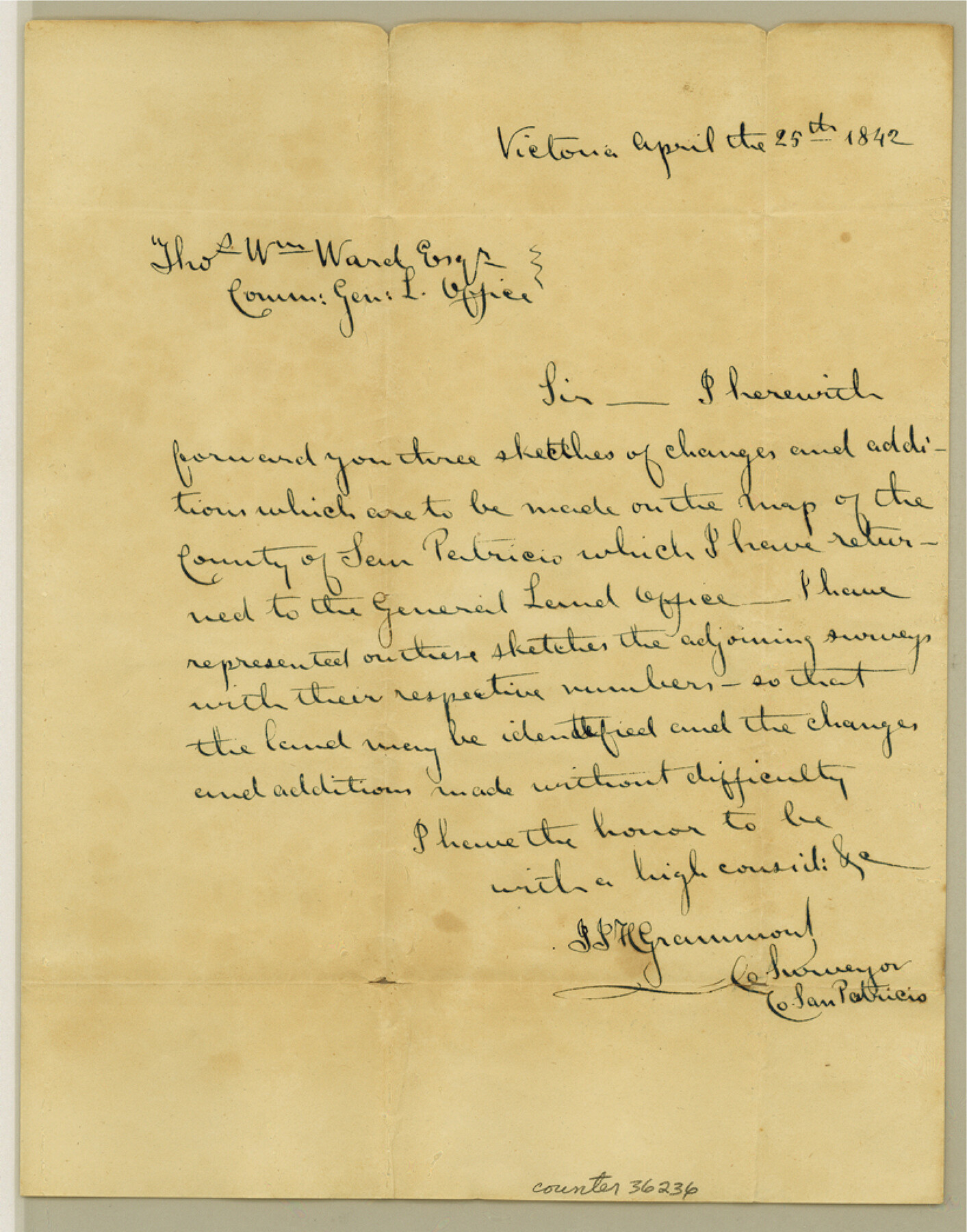
San Patricio County Sketch File 40
[Letter from County Surveyor that accompanied sketches sent to the GLO]
-
Map/Doc
36236
-
Collection
General Map Collection
-
Object Dates
4/25/1842 (Creation Date)
12/11/1984 (File Date)
-
People and Organizations
J.J.H. Grammond ()
-
Counties
San Patricio
-
Subjects
Surveying Sketch File
-
Height x Width
10.5 x 8.2 inches
26.7 x 20.8 cm
-
Medium
paper, manuscript
Part of: General Map Collection
Montague County Working Sketch 13

Print $20.00
- Digital $50.00
Montague County Working Sketch 13
1939
Size 26.0 x 20.6 inches
Map/Doc 71079
Brewster County Rolled Sketch 52

Print $40.00
- Digital $50.00
Brewster County Rolled Sketch 52
1935
Size 24.5 x 59.4 inches
Map/Doc 8479
Montgomery County Working Sketch 27

Print $20.00
- Digital $50.00
Montgomery County Working Sketch 27
1942
Size 42.1 x 33.4 inches
Map/Doc 71134
Culberson County Working Sketch 64

Print $20.00
- Digital $50.00
Culberson County Working Sketch 64
1975
Size 46.5 x 30.8 inches
Map/Doc 68518
Flight Mission No. BRE-2P, Frame 8, Nueces County

Print $20.00
- Digital $50.00
Flight Mission No. BRE-2P, Frame 8, Nueces County
1956
Size 18.7 x 22.6 inches
Map/Doc 86717
Hill County Sketch File 17

Print $4.00
- Digital $50.00
Hill County Sketch File 17
1860
Size 12.5 x 8.3 inches
Map/Doc 26484

Liberty County Working Sketch 42

Print $20.00
- Digital $50.00
Liberty County Working Sketch 42
1953
Size 24.0 x 35.8 inches
Map/Doc 70501
Carta de las provincias de Tejas Nuevo Santander, Nuevo Reino de Leon y Nueva Estremadura

Print $20.00
- Digital $50.00
Carta de las provincias de Tejas Nuevo Santander, Nuevo Reino de Leon y Nueva Estremadura
1773
Size 21.5 x 26.6 inches
Map/Doc 3031
Upton County Working Sketch 54

Print $20.00
- Digital $50.00
Upton County Working Sketch 54
1983
Size 23.2 x 37.7 inches
Map/Doc 69551
[Surveys along Cypress Creek]
![155, [Surveys along Cypress Creek], General Map Collection](https://historictexasmaps.com/wmedia_w700/maps/155.tif.jpg)
Print $2.00
- Digital $50.00
[Surveys along Cypress Creek]
1844
Size 6.0 x 6.1 inches
Map/Doc 155
Map of Polk Co.

Print $40.00
- Digital $50.00
Map of Polk Co.
1906
Size 52.0 x 43.0 inches
Map/Doc 16789
You may also like
[Map showing resurvey of Capitol Leagues in Hartley & Oldham Counties, Texas]
![1754, [Map showing resurvey of Capitol Leagues in Hartley & Oldham Counties, Texas], General Map Collection](https://historictexasmaps.com/wmedia_w700/maps/1754-1.tif.jpg)
Print $20.00
- Digital $50.00
[Map showing resurvey of Capitol Leagues in Hartley & Oldham Counties, Texas]
1918
Size 30.8 x 37.4 inches
Map/Doc 1754
[C.C.S.D. & R.G.N.G. RR. Co. Blk. G east thru T.&P. Blk 33]
![89775, [C.C.S.D. & R.G.N.G. RR. Co. Blk. G east thru T.&P. Blk 33], Twichell Survey Records](https://historictexasmaps.com/wmedia_w700/maps/89775-1.tif.jpg)
Print $40.00
- Digital $50.00
[C.C.S.D. & R.G.N.G. RR. Co. Blk. G east thru T.&P. Blk 33]
1901
Size 70.2 x 23.0 inches
Map/Doc 89775
Culberson County Working Sketch 48

Print $40.00
- Digital $50.00
Culberson County Working Sketch 48
1972
Size 49.3 x 39.0 inches
Map/Doc 68502
Red River County Working Sketch 55

Print $20.00
- Digital $50.00
Red River County Working Sketch 55
1971
Size 29.4 x 31.1 inches
Map/Doc 72038
Intracoastal Waterway - Laguna Madre - Rincon de San Jose to Chubby Island, Texas

Print $20.00
- Digital $50.00
Intracoastal Waterway - Laguna Madre - Rincon de San Jose to Chubby Island, Texas
1975
Size 16.0 x 37.1 inches
Map/Doc 73516
Atascosa County Rolled Sketch 8

Print $20.00
- Digital $50.00
Atascosa County Rolled Sketch 8
1942
Size 34.8 x 41.9 inches
Map/Doc 8427
Throckmorton County Sketch File 3

Print $6.00
- Digital $50.00
Throckmorton County Sketch File 3
Size 10.4 x 10.2 inches
Map/Doc 38052
The Republic County of Sabine. December 29, 1845

Print $20.00
The Republic County of Sabine. December 29, 1845
2020
Size 17.6 x 21.7 inches
Map/Doc 96270

Leon County Rolled Sketch 16

Print $40.00
- Digital $50.00
Leon County Rolled Sketch 16
1981
Size 42.8 x 65.3 inches
Map/Doc 9433
Hays County Sketch File 16a

Print $4.00
- Digital $50.00
Hays County Sketch File 16a
1871
Size 8.2 x 9.7 inches
Map/Doc 26229
Edwards County Working Sketch 140

Print $20.00
- Digital $50.00
Edwards County Working Sketch 140
2014
Size 36.1 x 41.1 inches
Map/Doc 93665