Schleicher County Sketch File 37
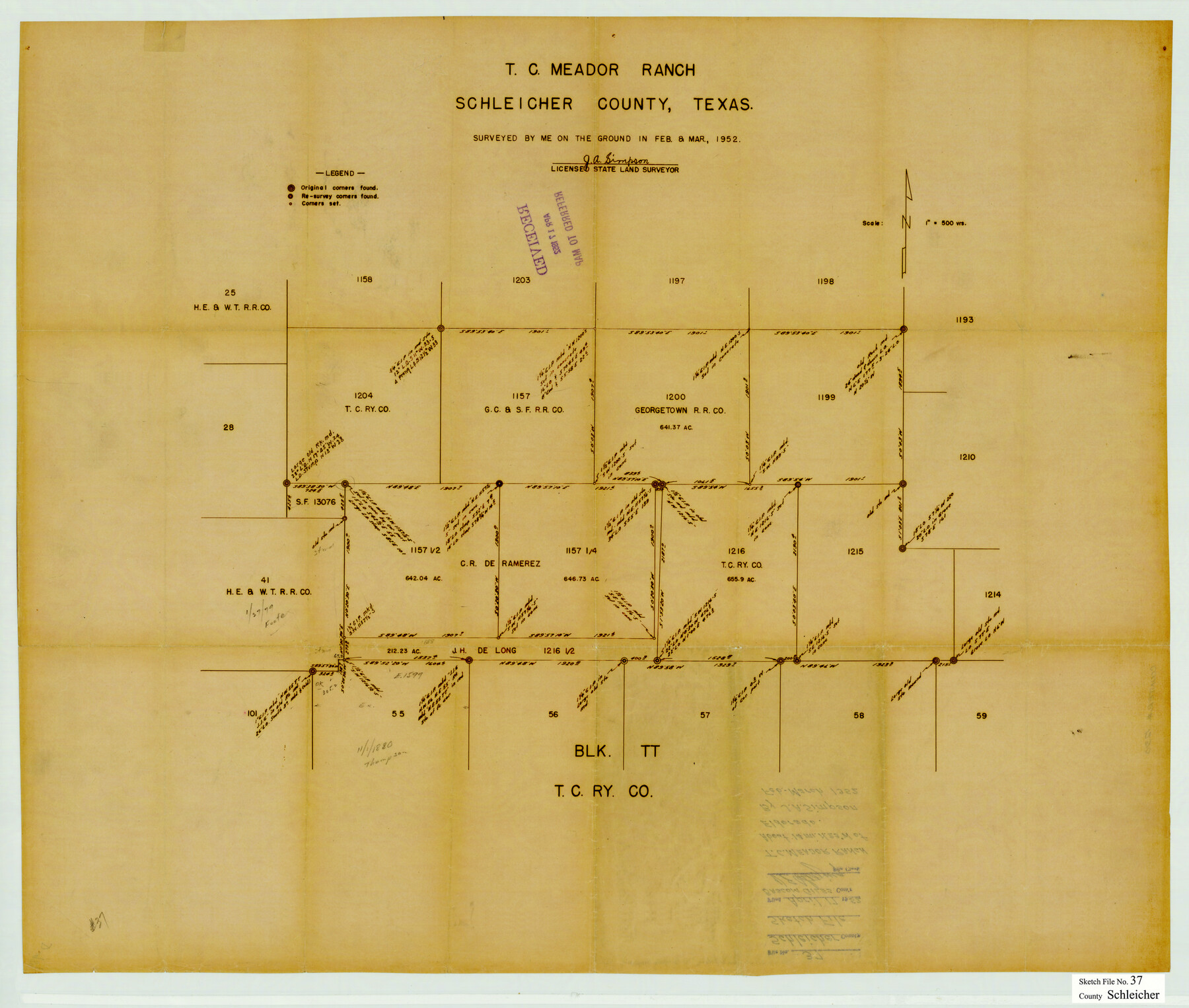
T.C. Meador Ranch, Schleicher County, Texas [in the north part of the county]
-
Map/Doc
12310
-
Collection
General Map Collection
-
Object Dates
3/1952 (Creation Date)
4/17/1952 (File Date)
-
People and Organizations
J.A. Simpson (Surveyor/Engineer)
-
Counties
Schleicher
-
Subjects
Surveying Sketch File
-
Height x Width
24.9 x 29.3 inches
63.3 x 74.4 cm
-
Medium
blueprint/diazo
-
Scale
1" = 500 varas
-
Features
T.C. Meador Ranch
Part of: General Map Collection
Kent County Working Sketch 20

Print $40.00
- Digital $50.00
Kent County Working Sketch 20
1980
Size 50.7 x 44.1 inches
Map/Doc 70027
Galveston Bay

Print $20.00
- Digital $50.00
Galveston Bay
1921
Size 43.4 x 35.4 inches
Map/Doc 69872
Karnes County Working Sketch Graphic Index

Print $20.00
- Digital $50.00
Karnes County Working Sketch Graphic Index
1921
Size 45.0 x 40.3 inches
Map/Doc 76600
Harrison County Working Sketch 1

Print $20.00
- Digital $50.00
Harrison County Working Sketch 1
1919
Size 22.6 x 25.6 inches
Map/Doc 66021
Jefferson County NRC Article 33.136 Sketch 10

Print $28.00
- Digital $50.00
Jefferson County NRC Article 33.136 Sketch 10
2012
Size 24.0 x 36.0 inches
Map/Doc 94575
Motley County Sketch File 35 (S)

Print $20.00
- Digital $50.00
Motley County Sketch File 35 (S)
Size 17.8 x 18.5 inches
Map/Doc 42150
Goliad County Working Sketch 23

Print $20.00
- Digital $50.00
Goliad County Working Sketch 23
1979
Size 26.8 x 32.9 inches
Map/Doc 63213
Garza County Rolled Sketch 14

Print $41.00
- Digital $50.00
Garza County Rolled Sketch 14
1913
Size 10.0 x 15.2 inches
Map/Doc 45234
Flight Mission No. BRA-6M, Frame 77, Jefferson County

Print $20.00
- Digital $50.00
Flight Mission No. BRA-6M, Frame 77, Jefferson County
1953
Size 18.6 x 22.6 inches
Map/Doc 85421
Lubbock County Working Sketch 9

Print $40.00
- Digital $50.00
Lubbock County Working Sketch 9
1990
Size 28.5 x 57.3 inches
Map/Doc 70669
Presidio County Sketch File 119

Print $14.00
- Digital $50.00
Presidio County Sketch File 119
1996
Size 14.3 x 9.0 inches
Map/Doc 34927
Reagan County Working Sketch 12

Print $20.00
- Digital $50.00
Reagan County Working Sketch 12
1948
Size 24.1 x 44.9 inches
Map/Doc 71852
You may also like
Revised Map of Austin, Texas

Print $20.00
Revised Map of Austin, Texas
1885
Size 16.5 x 14.0 inches
Map/Doc 76272
Somervell County Sketch File 5

Print $95.00
- Digital $50.00
Somervell County Sketch File 5
1871
Size 8.8 x 7.7 inches
Map/Doc 36802
Maverick County Working Sketch 10

Print $40.00
- Digital $50.00
Maverick County Working Sketch 10
1959
Size 52.9 x 39.1 inches
Map/Doc 70902
Harrison County Working Sketch 1
Print $20.00
- Digital $50.00
Harrison County Working Sketch 1
1919
Size 22.6 x 25.6 inches
Map/Doc 66021
Carte Générale des États-Unis pour servir a l'Histoire de la Louisiane

Print $20.00
- Digital $50.00
Carte Générale des États-Unis pour servir a l'Histoire de la Louisiane
1829
Size 12.0 x 15.9 inches
Map/Doc 97260
Brewster County Working Sketch Graphic Index, North Part, Sheet 1 (Sketches 1 to 86)

Print $20.00
- Digital $50.00
Brewster County Working Sketch Graphic Index, North Part, Sheet 1 (Sketches 1 to 86)
1956
Size 42.3 x 40.4 inches
Map/Doc 76473
Harris County Rolled Sketch P57

Print $20.00
- Digital $50.00
Harris County Rolled Sketch P57
1929
Size 29.6 x 37.5 inches
Map/Doc 9118
Denton County Working Sketch 16

Print $20.00
- Digital $50.00
Denton County Working Sketch 16
1973
Size 31.5 x 39.1 inches
Map/Doc 68621
Map of Upton County

Print $20.00
- Digital $50.00
Map of Upton County
1899
Size 46.0 x 40.2 inches
Map/Doc 63087
Flight Mission No. BRA-8M, Frame 126, Jefferson County

Print $20.00
- Digital $50.00
Flight Mission No. BRA-8M, Frame 126, Jefferson County
1953
Size 19.1 x 22.7 inches
Map/Doc 85622
University Land Field Notes for Blocks 12, 13, and 14 in Andrews County, and Block 11 in Andrews and Winkler Counties

University Land Field Notes for Blocks 12, 13, and 14 in Andrews County, and Block 11 in Andrews and Winkler Counties
Map/Doc 81711
Maverick County Working Sketch Graphic Index

Print $20.00
- Digital $50.00
Maverick County Working Sketch Graphic Index
1947
Size 46.4 x 30.3 inches
Map/Doc 76635