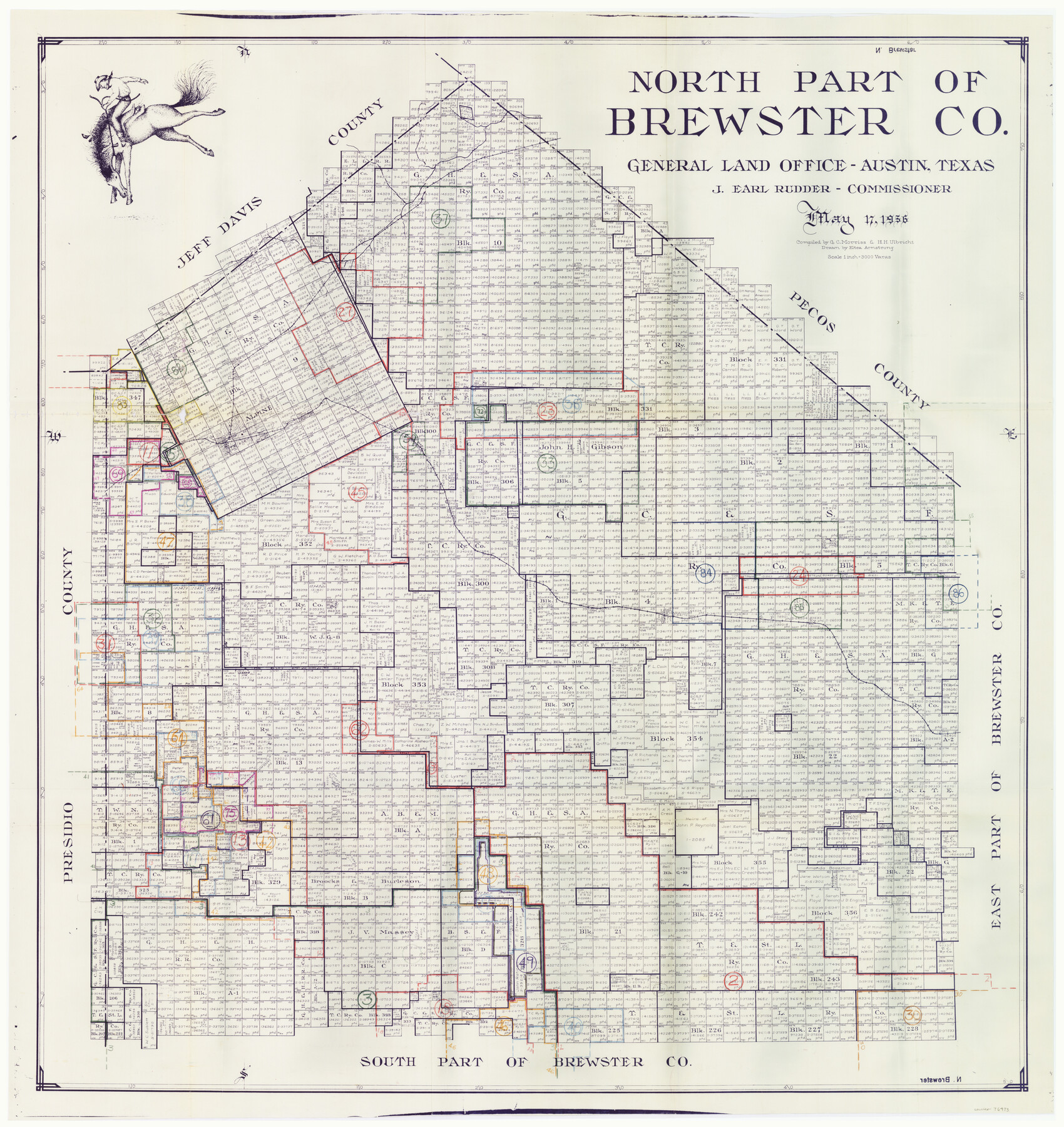
Brewster County Working Sketch Graphic Index, North Part, Sheet 1 (Sketches 1 to 86)
-
Map/Doc
76473
-
Collection
General Map Collection
-
Object Dates
5/17/1956 (Creation Date)
-
People and Organizations
G.C. Morriss (Compiler)
Herbert H. Ulbricht (Compiler)
Eltea Armstrong (Draftsman)
-
Counties
Brewster
-
Subjects
County Surveying Working Sketch
-
Height x Width
42.3 x 40.4 inches
107.4 x 102.6 cm
-
Scale
1" = 3000 varas
-
Comments
Please note that Brewster County Working Sketch 17 is missing and therefore no longer available.
Part of: General Map Collection
Oldham County Boundary File 2

Print $10.00
- Digital $50.00
Oldham County Boundary File 2
Size 14.2 x 8.6 inches
Map/Doc 57766
Shipping Safety Fairways and Anchorage Areas, Gulf of Mexico - Brazos Santiago Pass to Calcasieu Pass

Print $20.00
- Digital $50.00
Shipping Safety Fairways and Anchorage Areas, Gulf of Mexico - Brazos Santiago Pass to Calcasieu Pass
1968
Size 30.3 x 42.1 inches
Map/Doc 73632
Map of Limestone County

Print $20.00
- Digital $50.00
Map of Limestone County
1858
Size 23.2 x 23.8 inches
Map/Doc 3819
Amistad International Reservoir on Rio Grande 76

Print $20.00
- Digital $50.00
Amistad International Reservoir on Rio Grande 76
1949
Size 28.5 x 40.2 inches
Map/Doc 75504
Shelby County

Print $40.00
- Digital $50.00
Shelby County
1897
Size 43.9 x 49.3 inches
Map/Doc 16814
Flight Mission No. CRC-2R, Frame 200, Chambers County

Print $20.00
- Digital $50.00
Flight Mission No. CRC-2R, Frame 200, Chambers County
1956
Size 18.8 x 22.4 inches
Map/Doc 84778
Coryell County Sketch File 23

Print $24.00
- Digital $50.00
Coryell County Sketch File 23
1948
Size 11.2 x 8.8 inches
Map/Doc 19387
Travis County Rolled Sketch 32A

Print $40.00
- Digital $50.00
Travis County Rolled Sketch 32A
Size 57.6 x 37.3 inches
Map/Doc 10013
Liberty County Working Sketch 58

Print $40.00
- Digital $50.00
Liberty County Working Sketch 58
1968
Size 37.3 x 70.3 inches
Map/Doc 70518
Supreme Court of the United States, October Term, 1923, No. 15, Original - The State of Oklahoma, Complainant vs. The State of Texas, Defendant, The United States, Intervener; Report of the Boundary Commissioners

Print $20.00
- Digital $50.00
Supreme Court of the United States, October Term, 1923, No. 15, Original - The State of Oklahoma, Complainant vs. The State of Texas, Defendant, The United States, Intervener; Report of the Boundary Commissioners
1923
Size 39.4 x 39.6 inches
Map/Doc 75116
South Part Pecos County

Print $20.00
- Digital $50.00
South Part Pecos County
1976
Size 37.9 x 45.3 inches
Map/Doc 95613
Pecos County Sketch File 31 1/2a

Print $14.00
- Digital $50.00
Pecos County Sketch File 31 1/2a
1931
Size 11.2 x 8.6 inches
Map/Doc 33705
You may also like

Foard County Sketch File 9

Print $20.00
- Digital $50.00
Foard County Sketch File 9
1882
Size 19.7 x 17.1 inches
Map/Doc 11492
Fisher County Working Sketch 6

Print $20.00
- Digital $50.00
Fisher County Working Sketch 6
1929
Size 38.7 x 33.6 inches
Map/Doc 69140
Harris County Sketch File 73

Print $6.00
- Digital $50.00
Harris County Sketch File 73
1942
Size 11.3 x 8.9 inches
Map/Doc 25539
Uvalde County Rolled Sketch 14

Print $20.00
- Digital $50.00
Uvalde County Rolled Sketch 14
1977
Size 22.0 x 25.9 inches
Map/Doc 8098
Collin County Sketch File 7

Print $40.00
- Digital $50.00
Collin County Sketch File 7
1852
Size 17.3 x 14.0 inches
Map/Doc 18866
Baylor County Sketch File A5

Print $6.00
- Digital $50.00
Baylor County Sketch File A5
Size 10.4 x 8.8 inches
Map/Doc 14088
Webb County Rolled Sketch 54

Print $20.00
- Digital $50.00
Webb County Rolled Sketch 54
1935
Size 24.8 x 18.6 inches
Map/Doc 8207
Orange County Rolled Sketch 25

Print $20.00
- Digital $50.00
Orange County Rolled Sketch 25
1951
Size 29.0 x 43.5 inches
Map/Doc 10723

General Highway Map, Jim Wells County, Texas

Print $20.00
General Highway Map, Jim Wells County, Texas
1940
Size 18.4 x 24.8 inches
Map/Doc 79148
Brazoria County Rolled Sketch 38

Print $20.00
- Digital $50.00
Brazoria County Rolled Sketch 38
1949
Size 44.6 x 39.5 inches
Map/Doc 8460