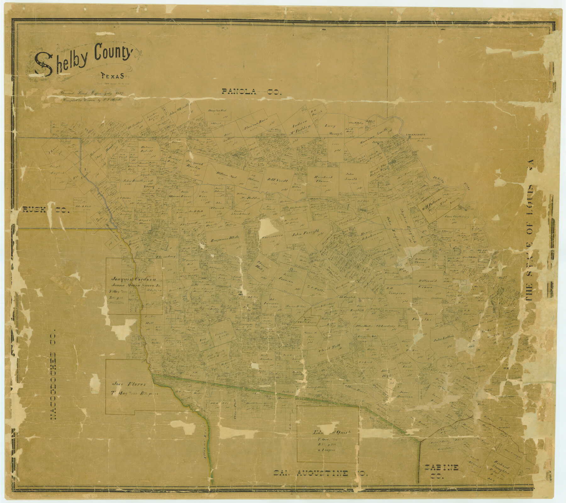
Shelby County
-
Map/Doc
16814
-
Collection
General Map Collection
-
Object Dates
1897 (Creation Date)
-
People and Organizations
Texas General Land Office (Publisher)
P.F. Appell (Draftsman)
P.F. Appell (Compiler)
-
Counties
Shelby
-
Subjects
County
-
Height x Width
43.9 x 49.3 inches
111.5 x 125.2 cm
-
Comments
Conservation funded in 2004 with donation from Larry Parker McNeill.
-
Features
Shelbyville
Center
Logansport and Brooklin Ferry
Hooper's Creek
Grigsby
Howers Creek
Sip Bayou
Taneha
Attoyac River
Hamilton
Arenilo Bayou
Dillard Creek
Bogg's Creek
South Fork of Bayou Blue
Bayou Blue
Haile
Caney Bayou
Huana Bayou
Baer Bayou
Stockman
Flat Fork of Taneha Bayou
Sabine River
Taneha Bayou
Timpson
Brooklin
Brooklin Post Office
McFadden Creek
Joaquin
Brooklin Ferry
Logansport Ferry
Logansport
Part of: General Map Collection
Southern Part of Laguna Madre

Print $20.00
- Digital $50.00
Southern Part of Laguna Madre
1987
Size 44.5 x 34.7 inches
Map/Doc 73548
Flight Mission No. CRE-2R, Frame 86, Jackson County

Print $20.00
- Digital $50.00
Flight Mission No. CRE-2R, Frame 86, Jackson County
1956
Size 16.0 x 15.8 inches
Map/Doc 85358
Swisher County Working Sketch Graphic Index

Print $20.00
- Digital $50.00
Swisher County Working Sketch Graphic Index
1941
Size 41.5 x 35.9 inches
Map/Doc 76707
Calhoun County Sketch File 10

Print $11.00
- Digital $50.00
Calhoun County Sketch File 10
1956
Size 14.3 x 8.8 inches
Map/Doc 35940
Hays County Sketch File 12

Print $4.00
- Digital $50.00
Hays County Sketch File 12
1866
Size 8.5 x 7.2 inches
Map/Doc 26218
Upton County Rolled Sketch 9

Print $20.00
- Digital $50.00
Upton County Rolled Sketch 9
1911
Size 15.3 x 27.0 inches
Map/Doc 8068
Stephens County Sketch File 13

Print $4.00
- Digital $50.00
Stephens County Sketch File 13
Size 11.2 x 8.8 inches
Map/Doc 37063
Stephens County Sketch File 15

Print $4.00
- Digital $50.00
Stephens County Sketch File 15
1890
Size 9.1 x 6.7 inches
Map/Doc 37068
Wharton County Sketch File 24

Print $20.00
- Digital $50.00
Wharton County Sketch File 24
1919
Size 19.9 x 25.5 inches
Map/Doc 12668
Flight Mission No. DAG-24K, Frame 147, Matagorda County

Print $20.00
- Digital $50.00
Flight Mission No. DAG-24K, Frame 147, Matagorda County
1953
Size 17.1 x 15.7 inches
Map/Doc 86561
Red River County Rolled Sketch 8

Print $20.00
- Digital $50.00
Red River County Rolled Sketch 8
Size 32.5 x 17.3 inches
Map/Doc 7474
[Galveston, Harrisburg & San Antonio through El Paso County]
![64008, [Galveston, Harrisburg & San Antonio through El Paso County], General Map Collection](https://historictexasmaps.com/wmedia_w700/maps/64008.tif.jpg)
Print $20.00
- Digital $50.00
[Galveston, Harrisburg & San Antonio through El Paso County]
1906
Size 13.7 x 33.8 inches
Map/Doc 64008
You may also like
La Salle County Working Sketch 28

Print $20.00
- Digital $50.00
La Salle County Working Sketch 28
1954
Size 36.8 x 37.8 inches
Map/Doc 70329
Kerr County Working Sketch 3

Print $20.00
- Digital $50.00
Kerr County Working Sketch 3
1944
Size 15.7 x 21.0 inches
Map/Doc 70034
Karnes County Sketch File 9

Print $6.00
- Digital $50.00
Karnes County Sketch File 9
1876
Size 12.6 x 8.1 inches
Map/Doc 28594
Kimble County Working Sketch 33

Print $20.00
- Digital $50.00
Kimble County Working Sketch 33
1945
Size 29.8 x 29.2 inches
Map/Doc 70101
Pecos County Sketch File 34

Print $4.00
- Digital $50.00
Pecos County Sketch File 34
Size 11.1 x 8.5 inches
Map/Doc 33714
Denton County Sketch File 34

Print $4.00
- Digital $50.00
Denton County Sketch File 34
1880
Size 8.9 x 5.4 inches
Map/Doc 20764
Schleicher County Working Sketch 6

Print $20.00
- Digital $50.00
Schleicher County Working Sketch 6
1917
Size 24.6 x 19.3 inches
Map/Doc 63808
Montague County Working Sketch 19

Print $20.00
- Digital $50.00
Montague County Working Sketch 19
1952
Size 26.4 x 21.5 inches
Map/Doc 71085
Flight Mission No. CRK-8P, Frame 116, Refugio County

Print $20.00
- Digital $50.00
Flight Mission No. CRK-8P, Frame 116, Refugio County
1956
Size 18.3 x 22.1 inches
Map/Doc 86971
Regni Mexicani seu Novae Hispaniae, Ludovicianae, N. Angliae, Carolinae, Virginiae, et Pennsylvaniae

Print $20.00
- Digital $50.00
Regni Mexicani seu Novae Hispaniae, Ludovicianae, N. Angliae, Carolinae, Virginiae, et Pennsylvaniae
1720
Size 22.5 x 26.5 inches
Map/Doc 93408
Martin County Working Sketch 10

Print $40.00
- Digital $50.00
Martin County Working Sketch 10
1971
Size 50.0 x 37.4 inches
Map/Doc 70828
Parker County Sketch File 37

Print $4.00
- Digital $50.00
Parker County Sketch File 37
Size 4.8 x 8.1 inches
Map/Doc 33581