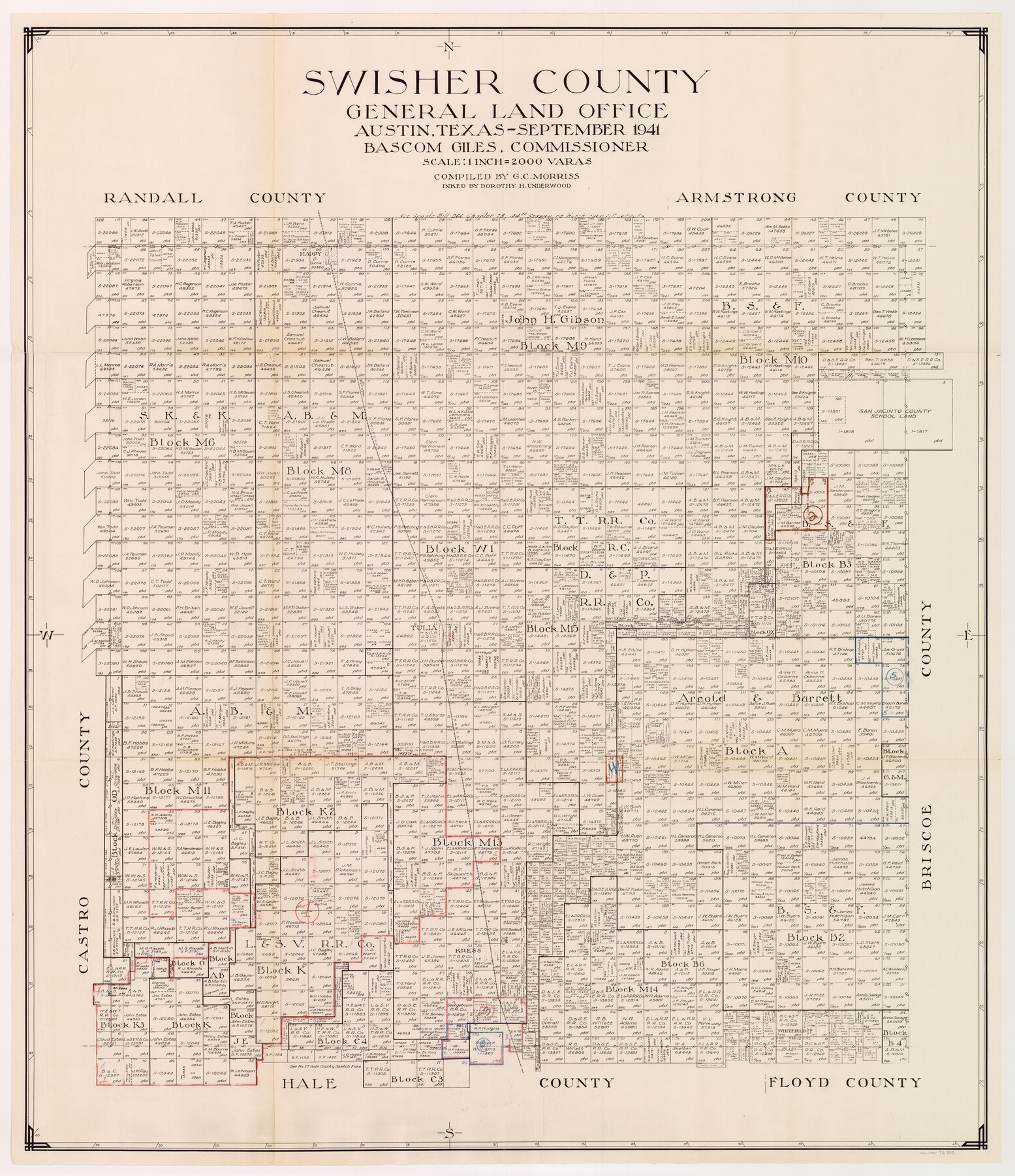
Swisher County Working Sketch Graphic Index
-
Map/Doc
76707
-
Collection
General Map Collection
-
Object Dates
9/1941 (Creation Date)
-
People and Organizations
G.C. Morriss (Compiler)
Dorothy H. Underwood (Inker)
-
Counties
Swisher
-
Subjects
County Surveying Working Sketch
-
Height x Width
41.5 x 35.9 inches
105.4 x 91.2 cm
-
Scale
1" = 2000 varas
Part of: General Map Collection
Leon County Working Sketch 26

Print $20.00
- Digital $50.00
Leon County Working Sketch 26
1969
Size 43.1 x 46.9 inches
Map/Doc 70425
Hopkins County Boundary File 1

Print $26.00
- Digital $50.00
Hopkins County Boundary File 1
Size 12.3 x 7.9 inches
Map/Doc 55044
Montgomery County Rolled Sketch 40A

Print $40.00
- Digital $50.00
Montgomery County Rolled Sketch 40A
1970
Size 40.4 x 57.5 inches
Map/Doc 9547
Menard County Boundary File 2

Print $38.00
- Digital $50.00
Menard County Boundary File 2
Size 8.9 x 9.1 inches
Map/Doc 57046
Flight Mission No. BRA-7M, Frame117, Jefferson County

Print $20.00
- Digital $50.00
Flight Mission No. BRA-7M, Frame117, Jefferson County
1953
Size 18.7 x 22.4 inches
Map/Doc 85511

Eastland County Working Sketch 40

Print $20.00
- Digital $50.00
Eastland County Working Sketch 40
1970
Size 27.9 x 26.0 inches
Map/Doc 68821
Neches River, Blackburn Bridge Sheet

Print $4.00
- Digital $50.00
Neches River, Blackburn Bridge Sheet
1938
Size 27.6 x 20.5 inches
Map/Doc 65083
Newton County Sketch File 15

Print $20.00
- Digital $50.00
Newton County Sketch File 15
1878
Size 29.1 x 16.8 inches
Map/Doc 42156
Flight Mission No. DCL-5C, Frame 76, Kenedy County

Print $20.00
- Digital $50.00
Flight Mission No. DCL-5C, Frame 76, Kenedy County
1943
Size 18.4 x 22.4 inches
Map/Doc 85859
Map of Lampasas Co.

Print $20.00
- Digital $50.00
Map of Lampasas Co.
1888
Size 34.4 x 42.4 inches
Map/Doc 5080
Refugio County

Print $20.00
- Digital $50.00
Refugio County
1883
Size 20.1 x 28.9 inches
Map/Doc 3984
You may also like
Briscoe County Working Sketch 6

Print $20.00
- Digital $50.00
Briscoe County Working Sketch 6
1940
Size 31.0 x 24.5 inches
Map/Doc 67809
Austin County Sketch File 8

Print $40.00
- Digital $50.00
Austin County Sketch File 8
1894
Size 19.3 x 19.9 inches
Map/Doc 10873
Wharton County Working Sketch 25

Print $20.00
- Digital $50.00
Wharton County Working Sketch 25
1993
Size 20.0 x 25.5 inches
Map/Doc 72489
University Land Field Notes for Blocks A, B, C, D, E, F, G, H, I, and J in Hudspeth County

University Land Field Notes for Blocks A, B, C, D, E, F, G, H, I, and J in Hudspeth County
Map/Doc 81712
Swisher County Sketch File 6

Print $20.00
- Digital $50.00
Swisher County Sketch File 6
Size 15.4 x 12.1 inches
Map/Doc 12404
[H. & T. C. Block 47 and vicinity]
![91171, [H. & T. C. Block 47 and vicinity], Twichell Survey Records](https://historictexasmaps.com/wmedia_w700/maps/91171-1.tif.jpg)
Print $20.00
- Digital $50.00
[H. & T. C. Block 47 and vicinity]
1891
Size 19.4 x 15.3 inches
Map/Doc 91171
Matagorda County Rolled Sketch 37A

Print $40.00
- Digital $50.00
Matagorda County Rolled Sketch 37A
Size 48.7 x 41.1 inches
Map/Doc 10195
Harris County Working Sketch 64

Print $20.00
- Digital $50.00
Harris County Working Sketch 64
1954
Size 32.1 x 26.2 inches
Map/Doc 65956
Brewster County Working Sketch 115

Print $40.00
- Digital $50.00
Brewster County Working Sketch 115
1985
Size 49.6 x 43.4 inches
Map/Doc 67715
Bosque County

Print $20.00
- Digital $50.00
Bosque County
1945
Size 42.6 x 33.0 inches
Map/Doc 77215
Flight Mission No. DQN-1K, Frame 78, Calhoun County

Print $20.00
- Digital $50.00
Flight Mission No. DQN-1K, Frame 78, Calhoun County
1953
Size 18.5 x 22.1 inches
Map/Doc 84163
Sterling County Rolled Sketch 20

Print $20.00
- Digital $50.00
Sterling County Rolled Sketch 20
Size 30.5 x 34.5 inches
Map/Doc 9952