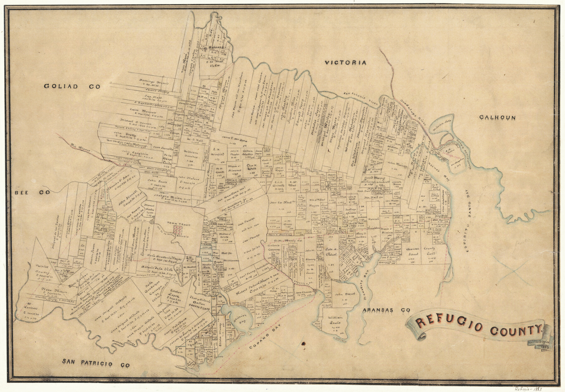
Refugio County
-
Map/Doc
3984
-
Collection
General Map Collection
-
Object Dates
1883 (Creation Date)
-
Counties
Refugio
-
Subjects
County
-
Height x Width
20.1 x 28.9 inches
51.1 x 73.4 cm
-
Features
St. Charles Bay
San Antonio Bay
Salinas Creek
Emmedio Creek
Goose Island
Copano
St. Mary
Aransas River
Mission Bay
Copano Bay
Preston
Arroyo Sauce
Chocolate Bay
Copano Creek
Cavasso Creek
San Antonio River
Burgelines Creek
Willow Creek
Rio de la Mission
Refugio
Middle Creek
Emmedio Creek
Espiritu Santo Bay
Guadalupe Bayou
Heine's Bayou
El Sarco River
Rio Blanco
Mission Lake
Guadalupe River
Part of: General Map Collection
Kimble County Sketch File 26

Print $4.00
- Digital $50.00
Kimble County Sketch File 26
1912
Size 7.8 x 13.0 inches
Map/Doc 28969
Gonzales County Working Sketch 4b

Print $20.00
- Digital $50.00
Gonzales County Working Sketch 4b
1979
Size 21.2 x 27.3 inches
Map/Doc 63220
Crane County Working Sketch 29

Print $20.00
- Digital $50.00
Crane County Working Sketch 29
1976
Size 45.4 x 36.5 inches
Map/Doc 68306
Leon County Sketch File 14

Print $6.00
- Digital $50.00
Leon County Sketch File 14
Size 13.2 x 8.8 inches
Map/Doc 29767
Coryell County Sketch File 17 1/2

Print $20.00
- Digital $50.00
Coryell County Sketch File 17 1/2
Size 16.0 x 23.6 inches
Map/Doc 11182
Dimmit County Sketch File 20a

Print $2.00
- Digital $50.00
Dimmit County Sketch File 20a
Size 9.3 x 4.3 inches
Map/Doc 21103
Texas State Boundary Line 5

Print $48.00
- Digital $50.00
Texas State Boundary Line 5
1907
Size 12.4 x 21.1 inches
Map/Doc 74959
Terry County Working Sketch 4

Print $20.00
- Digital $50.00
Terry County Working Sketch 4
Size 24.9 x 29.6 inches
Map/Doc 62109
Bastrop County Working Sketch 16

Print $20.00
- Digital $50.00
Bastrop County Working Sketch 16
1998
Size 39.2 x 34.1 inches
Map/Doc 67316
Hudspeth County Working Sketch 51

Print $20.00
- Digital $50.00
Hudspeth County Working Sketch 51
Size 32.8 x 24.5 inches
Map/Doc 66336
Tarrant County Working Sketch 23

Print $20.00
- Digital $50.00
Tarrant County Working Sketch 23
2001
Size 15.9 x 15.6 inches
Map/Doc 62440
Harrison County Working Sketch 32

Print $20.00
- Digital $50.00
Harrison County Working Sketch 32
2015
Size 29.9 x 24.0 inches
Map/Doc 93724
You may also like
In the Supreme Court of the United States The State of Oklahoma, Complainant vs. The State of Texas, Defendant, The United States of America, Intervener - 1921

Print $40.00
- Digital $50.00
In the Supreme Court of the United States The State of Oklahoma, Complainant vs. The State of Texas, Defendant, The United States of America, Intervener - 1921
1921
Size 25.7 x 61.1 inches
Map/Doc 75127
Fractional Township No. 8 South Range No. 3 East of the Indian Meridian, Indian Territory

Print $20.00
- Digital $50.00
Fractional Township No. 8 South Range No. 3 East of the Indian Meridian, Indian Territory
1898
Size 19.2 x 24.4 inches
Map/Doc 75205
Hemphill County Texas

Print $20.00
- Digital $50.00
Hemphill County Texas
Size 21.9 x 24.6 inches
Map/Doc 92183
La Louisiane, Suivant les Nouvelles Observations de Messrs de l'Academie Royale des Sciences

Print $20.00
La Louisiane, Suivant les Nouvelles Observations de Messrs de l'Academie Royale des Sciences
1735
Size 9.1 x 11.9 inches
Map/Doc 95279

Reagan County Sketch File 32

Print $6.00
- Digital $50.00
Reagan County Sketch File 32
1954
Size 11.5 x 9.0 inches
Map/Doc 35025
El Paso County Working Sketch 24

Print $20.00
- Digital $50.00
El Paso County Working Sketch 24
1961
Size 26.4 x 22.0 inches
Map/Doc 69046


Clay County Boundary File 6

Print $2.00
- Digital $50.00
Clay County Boundary File 6
Size 8.1 x 3.5 inches
Map/Doc 51376
Hardeman County Sketch File 7

Print $10.00
- Digital $50.00
Hardeman County Sketch File 7
Size 8.9 x 14.1 inches
Map/Doc 24997
Pecos County Working Sketch 45

Print $20.00
- Digital $50.00
Pecos County Working Sketch 45
1946
Size 20.8 x 26.7 inches
Map/Doc 71517