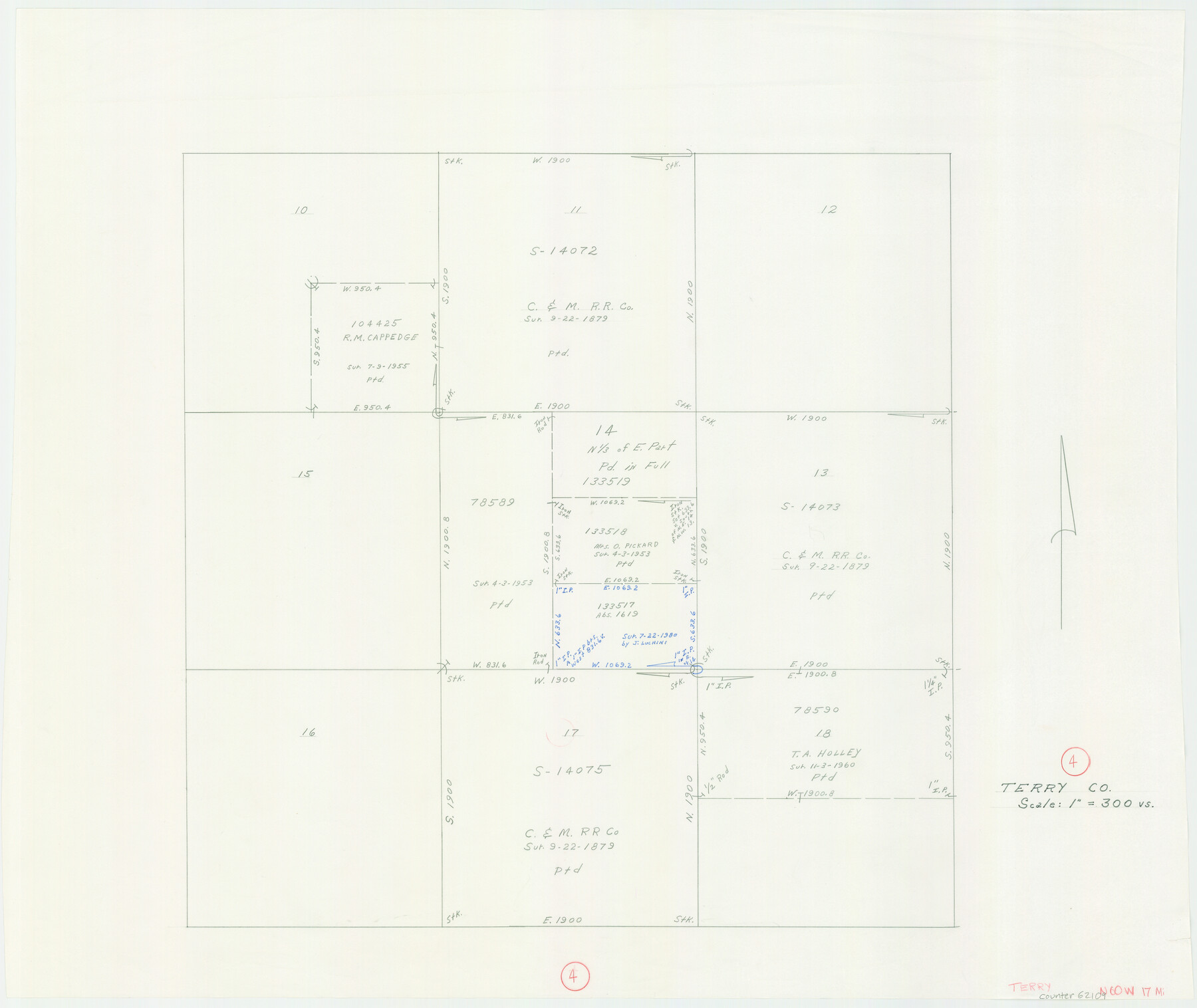
Terry County Working Sketch 4
-
Map/Doc
62109
-
Collection
General Map Collection
-
Counties
Terry
-
Subjects
Surveying Working Sketch
-
Height x Width
24.9 x 29.6 inches
63.3 x 75.2 cm
-
Scale
1" = 300 varas
Part of: General Map Collection
Hays County Working Sketch 2

Print $20.00
- Digital $50.00
Hays County Working Sketch 2
1920
Size 26.1 x 27.1 inches
Map/Doc 66076
Comanche County Working Sketch 6

Print $20.00
- Digital $50.00
Comanche County Working Sketch 6
1935
Size 26.4 x 17.8 inches
Map/Doc 68140
Fractional Township No. 7 South Range No. 6 East of the Indian Meridian, Indian Territory

Print $20.00
- Digital $50.00
Fractional Township No. 7 South Range No. 6 East of the Indian Meridian, Indian Territory
1898
Size 19.2 x 24.3 inches
Map/Doc 75211
Flight Mission No. BQY-4M, Frame 118, Harris County

Print $20.00
- Digital $50.00
Flight Mission No. BQY-4M, Frame 118, Harris County
1953
Size 18.6 x 22.3 inches
Map/Doc 85285
Harris County Rolled Sketch 89

Print $20.00
- Digital $50.00
Harris County Rolled Sketch 89
1899
Size 22.1 x 35.3 inches
Map/Doc 6128
Right of Way and Track Map, Dayton-Goose Creek Ry. Co., Station 0+00 to Station 190+00

Print $40.00
- Digital $50.00
Right of Way and Track Map, Dayton-Goose Creek Ry. Co., Station 0+00 to Station 190+00
1917
Size 24.8 x 56.6 inches
Map/Doc 64365
Rusk County Working Sketch Graphic Index

Print $20.00
- Digital $50.00
Rusk County Working Sketch Graphic Index
1932
Size 45.6 x 34.9 inches
Map/Doc 76688
[Surveys along Davidson's Creek]
![243, [Surveys along Davidson's Creek], General Map Collection](https://historictexasmaps.com/wmedia_w700/maps/243.tif.jpg)
Print $2.00
- Digital $50.00
[Surveys along Davidson's Creek]
Size 5.3 x 4.7 inches
Map/Doc 243
Erath County Rolled Sketch 3A

Print $20.00
- Digital $50.00
Erath County Rolled Sketch 3A
1982
Size 21.7 x 27.8 inches
Map/Doc 5865
Maverick County

Print $20.00
- Digital $50.00
Maverick County
1878
Size 33.4 x 21.4 inches
Map/Doc 3851
Hansford County Working Sketch 9

Print $20.00
- Digital $50.00
Hansford County Working Sketch 9
1984
Size 31.5 x 38.2 inches
Map/Doc 63381
Val Verde County Rolled Sketch 52

Print $20.00
- Digital $50.00
Val Verde County Rolled Sketch 52
1937
Size 31.8 x 23.0 inches
Map/Doc 8121
You may also like
Map of sections 1 & 2 of a survey of Padre Island made for the Office of the Attorney General of the State of Texas

Print $20.00
- Digital $50.00
Map of sections 1 & 2 of a survey of Padre Island made for the Office of the Attorney General of the State of Texas
1941
Size 40.8 x 39.8 inches
Map/Doc 2258
[Surveys in Southeast part of Stephens County]
![91909, [Surveys in Southeast part of Stephens County], Twichell Survey Records](https://historictexasmaps.com/wmedia_w700/maps/91909-1.tif.jpg)
Print $2.00
- Digital $50.00
[Surveys in Southeast part of Stephens County]
Size 9.1 x 7.0 inches
Map/Doc 91909
Flight Mission No. CON-2R, Frame 114, Stonewall County

Print $20.00
- Digital $50.00
Flight Mission No. CON-2R, Frame 114, Stonewall County
1957
Size 18.3 x 22.0 inches
Map/Doc 86989
[Portion of a sketch showing S.F. 7265]
![90386, [Portion of a sketch showing S.F. 7265], Twichell Survey Records](https://historictexasmaps.com/wmedia_w700/maps/90386-1.tif.jpg)
Print $2.00
- Digital $50.00
[Portion of a sketch showing S.F. 7265]
Size 13.3 x 9.1 inches
Map/Doc 90386
Webb County Rolled Sketch 41

Print $20.00
- Digital $50.00
Webb County Rolled Sketch 41
1941
Size 25.0 x 18.0 inches
Map/Doc 8196
Gregg County Working Sketch 17

Print $20.00
- Digital $50.00
Gregg County Working Sketch 17
1950
Size 29.7 x 26.2 inches
Map/Doc 63284
Flight Mission No. CRK-3P, Frame 63, Refugio County

Print $20.00
- Digital $50.00
Flight Mission No. CRK-3P, Frame 63, Refugio County
1956
Size 18.5 x 22.4 inches
Map/Doc 86905
Englewood Cemetery Slaton, Texas

Print $20.00
- Digital $50.00
Englewood Cemetery Slaton, Texas
1947
Size 24.4 x 35.2 inches
Map/Doc 92838
The Republic County of Robertson. January 30, 1841

Print $20.00
The Republic County of Robertson. January 30, 1841
2020
Size 16.9 x 21.7 inches
Map/Doc 96261
The Texas and Pacific Ry. Co., Station Map, Loraine, Texas

Print $20.00
- Digital $50.00
The Texas and Pacific Ry. Co., Station Map, Loraine, Texas
Size 11.6 x 18.6 inches
Map/Doc 64683
[Blocks 33-35, Township 5N]
![92029, [Blocks 33-35, Township 5N], Twichell Survey Records](https://historictexasmaps.com/wmedia_w700/maps/92029-1.tif.jpg)
Print $20.00
- Digital $50.00
[Blocks 33-35, Township 5N]
Size 37.4 x 23.8 inches
Map/Doc 92029
