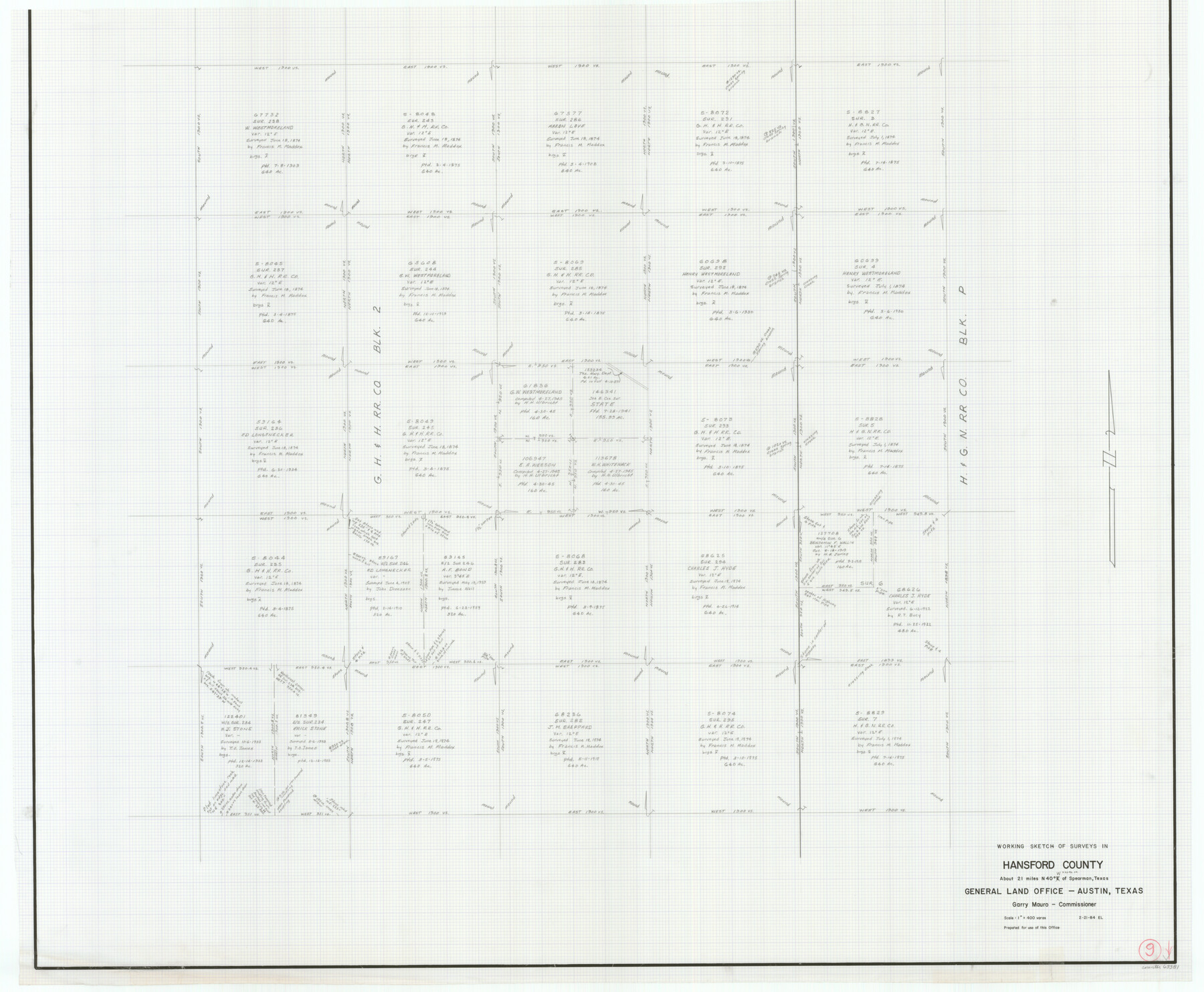
Hansford County Working Sketch 9
-
Map/Doc
63381
-
Collection
General Map Collection
-
Object Dates
2/21/1984 (Creation Date)
-
People and Organizations
Elisandro Leos (Draftsman)
-
Counties
Hansford
-
Subjects
Surveying Working Sketch
-
Height x Width
31.5 x 38.2 inches
80.0 x 97.0 cm
-
Scale
1" = 400 varas
Part of: General Map Collection
Flight Mission No. DQN-3K, Frame 12, Calhoun County

Print $20.00
- Digital $50.00
Flight Mission No. DQN-3K, Frame 12, Calhoun County
1953
Size 18.8 x 22.4 inches
Map/Doc 84344
Jim Hogg County Working Sketch 11

Print $20.00
- Digital $50.00
Jim Hogg County Working Sketch 11
1979
Size 24.7 x 37.6 inches
Map/Doc 66597
Nueces County Sketch File 18

Print $4.00
- Digital $50.00
Nueces County Sketch File 18
1874
Size 10.2 x 7.2 inches
Map/Doc 32549
Flight Mission No. DAG-28K, Frame 28, Matagorda County

Print $20.00
- Digital $50.00
Flight Mission No. DAG-28K, Frame 28, Matagorda County
1953
Size 18.5 x 22.5 inches
Map/Doc 86596
Flight Mission No. DQN-3K, Frame 8, Calhoun County

Print $20.00
- Digital $50.00
Flight Mission No. DQN-3K, Frame 8, Calhoun County
1953
Size 18.5 x 22.1 inches
Map/Doc 84340
Bosque County Working Sketch 24

Print $20.00
- Digital $50.00
Bosque County Working Sketch 24
1994
Size 34.4 x 47.4 inches
Map/Doc 67457
Gaines County Sketch File 22

Print $20.00
- Digital $50.00
Gaines County Sketch File 22
1962
Size 18.1 x 23.4 inches
Map/Doc 11528
Denton County Working Sketch 17

Print $20.00
- Digital $50.00
Denton County Working Sketch 17
1973
Size 31.6 x 33.6 inches
Map/Doc 68622
Young County Rolled Sketch 5

Print $20.00
- Digital $50.00
Young County Rolled Sketch 5
Size 20.2 x 26.1 inches
Map/Doc 8293
Harris County Working Sketch 58

Print $20.00
- Digital $50.00
Harris County Working Sketch 58
1952
Size 24.1 x 26.5 inches
Map/Doc 65950
Concho County Working Sketch 20

Print $20.00
- Digital $50.00
Concho County Working Sketch 20
1957
Size 40.0 x 38.1 inches
Map/Doc 68202

You may also like
Duval County Boundary File 3c

Print $12.00
- Digital $50.00
Duval County Boundary File 3c
Size 11.7 x 8.4 inches
Map/Doc 52732
Section 39 Block Y

Print $20.00
- Digital $50.00
Section 39 Block Y
Size 23.9 x 19.4 inches
Map/Doc 92463
Prison Property, Walker County

Print $20.00
- Digital $50.00
Prison Property, Walker County
Size 16.3 x 15.9 inches
Map/Doc 94280
Hidalgo County Sketch File 16

Print $12.00
- Digital $50.00
Hidalgo County Sketch File 16
1914
Size 11.2 x 8.9 inches
Map/Doc 26437
[Meridian thru 19th St. Muni. Standpipe]
![92864, [Meridian thru 19th St. Muni. Standpipe], Twichell Survey Records](https://historictexasmaps.com/wmedia_w700/maps/92864-1.tif.jpg)
Print $20.00
- Digital $50.00
[Meridian thru 19th St. Muni. Standpipe]
Size 23.8 x 19.5 inches
Map/Doc 92864
Upton County Sketch File 18

Print $20.00
- Digital $50.00
Upton County Sketch File 18
1927
Size 18.9 x 29.4 inches
Map/Doc 12514
[Abstract Numbering Register - Anderson through Dimmit]
![82965, [Abstract Numbering Register - Anderson through Dimmit], General Map Collection](https://historictexasmaps.com/wmedia_w700/pdf_converted_jpg/qi_pdf_thumbnail_30612.jpg)
[Abstract Numbering Register - Anderson through Dimmit]
Map/Doc 82965
[Surveys in Polk and Tyler Counties, Liberty District]
![354, [Surveys in Polk and Tyler Counties, Liberty District], General Map Collection](https://historictexasmaps.com/wmedia_w700/maps/354.tif.jpg)
Print $2.00
- Digital $50.00
[Surveys in Polk and Tyler Counties, Liberty District]
1847
Size 10.8 x 8.1 inches
Map/Doc 354
Red River County Working Sketch 57

Print $20.00
- Digital $50.00
Red River County Working Sketch 57
1972
Size 31.5 x 28.7 inches
Map/Doc 72040
Matagorda County Working Sketch 6

Print $20.00
- Digital $50.00
Matagorda County Working Sketch 6
1950
Size 24.2 x 41.5 inches
Map/Doc 70864
Terry County Sketch File 8

Print $20.00
- Digital $50.00
Terry County Sketch File 8
1932
Size 23.2 x 42.5 inches
Map/Doc 10393
Irion County Sketch File 5

Print $16.00
- Digital $50.00
Irion County Sketch File 5
1900
Size 14.4 x 8.9 inches
Map/Doc 27463