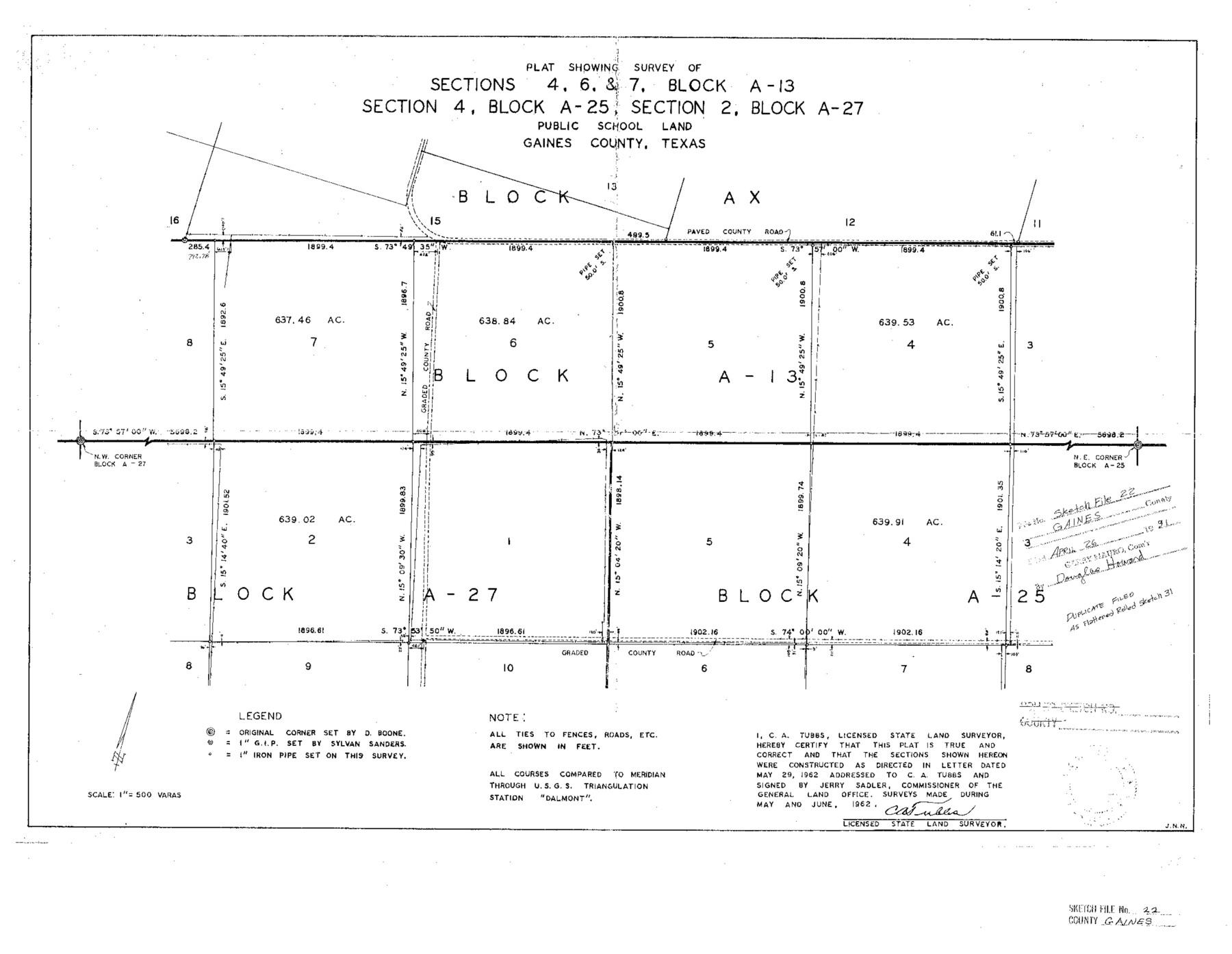
Gaines County Sketch File 22
Plat showing survey of sections 4, 6, & 7, Block A-13, section 4, Block A-25, section 2, Block A-27, Public School Land
-
Map/Doc
11528
-
Collection
General Map Collection
-
Object Dates
1962 (Creation Date)
1991/4/26 (File Date)
1962 (Survey Date)
-
People and Organizations
C.A. Tubbs (Surveyor/Engineer)
-
Counties
Gaines
-
Subjects
Surveying Sketch File
-
Height x Width
18.1 x 23.4 inches
46.0 x 59.4 cm
-
Medium
paper, photocopy
-
Scale
1" = 500 varas
-
Comments
See Gaines County Rolled Sketch 30 (5943) for duplicate sketch.
Related maps
Gaines County Rolled Sketch 30

Print $20.00
- Digital $50.00
Gaines County Rolled Sketch 30
1962
Size 19.4 x 26.3 inches
Map/Doc 5943
Part of: General Map Collection
Jefferson County Sketch File 56

Print $34.00
- Digital $50.00
Jefferson County Sketch File 56
2007
Map/Doc 93427

Concho, San Saba & Llano Valley Railway, Sterling City Branch, Texas. Right of Way and Track Map

Print $40.00
- Digital $50.00
Concho, San Saba & Llano Valley Railway, Sterling City Branch, Texas. Right of Way and Track Map
1910
Size 18.3 x 59.7 inches
Map/Doc 64439
Webb County Working Sketch 11

Print $20.00
- Digital $50.00
Webb County Working Sketch 11
1921
Size 17.8 x 16.3 inches
Map/Doc 72376
Flight Mission No. BRA-16M, Frame 180, Jefferson County

Print $20.00
- Digital $50.00
Flight Mission No. BRA-16M, Frame 180, Jefferson County
1953
Size 18.5 x 22.4 inches
Map/Doc 85778
[Old Coastal Chart of Texas Coast showing passes with depth readings]
![4662, [Old Coastal Chart of Texas Coast showing passes with depth readings], General Map Collection](https://historictexasmaps.com/wmedia_w700/maps/4662-1.tif.jpg)
Print $40.00
- Digital $50.00
[Old Coastal Chart of Texas Coast showing passes with depth readings]
Size 25.4 x 48.6 inches
Map/Doc 4662
Howard County Boundary File 1

Print $51.00
- Digital $50.00
Howard County Boundary File 1
Size 14.4 x 8.8 inches
Map/Doc 55086
Hidalgo County Rolled Sketch 8

Print $20.00
- Digital $50.00
Hidalgo County Rolled Sketch 8
1905
Size 20.1 x 26.3 inches
Map/Doc 6209
Willacy County Sketch File 1a

Print $272.00
- Digital $50.00
Willacy County Sketch File 1a
1977
Size 8.3 x 3.7 inches
Map/Doc 40239
Navasota and Grimes County, Texas

Navasota and Grimes County, Texas
Size 25.8 x 28.5 inches
Map/Doc 96865
El Paso County Working Sketch 10

Print $20.00
- Digital $50.00
El Paso County Working Sketch 10
1955
Size 31.1 x 20.5 inches
Map/Doc 69032
Carte Reduite du Golphe du Mexique et des isles de l'Amerique dressée au depost des cartes et plans de la Marine pour le service des vaisseaux du Roy

Print $20.00
- Digital $50.00
Carte Reduite du Golphe du Mexique et des isles de l'Amerique dressée au depost des cartes et plans de la Marine pour le service des vaisseaux du Roy
1774
Size 25.5 x 32.9 inches
Map/Doc 94097
You may also like
Schleicher County Sketch File 48

Print $4.00
- Digital $50.00
Schleicher County Sketch File 48
1953
Size 11.2 x 8.7 inches
Map/Doc 36558
[Sketch for Mineral Application 33721 - 33725 Incl. - Padre and Mustang Island]
![2871, [Sketch for Mineral Application 33721 - 33725 Incl. - Padre and Mustang Island], General Map Collection](https://historictexasmaps.com/wmedia_w700/maps/2871.tif.jpg)
Print $20.00
- Digital $50.00
[Sketch for Mineral Application 33721 - 33725 Incl. - Padre and Mustang Island]
1942
Size 27.0 x 22.4 inches
Map/Doc 2871
Clarendon, Texas, Donley Co.

Print $20.00
Clarendon, Texas, Donley Co.
1890
Size 17.4 x 28.6 inches
Map/Doc 93468
Chambers County Sketch File A

Print $20.00
- Digital $50.00
Chambers County Sketch File A
1900
Size 21.3 x 21.5 inches
Map/Doc 11071
Montgomery County Rolled Sketch 46

Print $20.00
- Digital $50.00
Montgomery County Rolled Sketch 46
2006
Size 28.2 x 23.0 inches
Map/Doc 87940
Sanderson and Terrell County, Texas

Sanderson and Terrell County, Texas
1920
Size 6.3 x 3.5 inches
Map/Doc 97073
[Scurry County]
![63030, [Scurry County], General Map Collection](https://historictexasmaps.com/wmedia_w700/maps/63030.tif.jpg)
Print $20.00
- Digital $50.00
[Scurry County]
1901
Size 34.3 x 42.5 inches
Map/Doc 63030
Map of the State of Texas Engraved to Illustrate Mitchell's School and Family Geography

Print $20.00
Map of the State of Texas Engraved to Illustrate Mitchell's School and Family Geography
1846
Size 12.0 x 9.6 inches
Map/Doc 87902
Sterling County Sketch File 15

Print $8.00
- Digital $50.00
Sterling County Sketch File 15
1935
Size 11.1 x 8.8 inches
Map/Doc 37150
Brooks County Working Sketch 2

Print $3.00
- Digital $50.00
Brooks County Working Sketch 2
Size 10.0 x 16.2 inches
Map/Doc 67786
Coleman County Sketch File 43

Print $12.00
- Digital $50.00
Coleman County Sketch File 43
1892
Size 9.2 x 8.8 inches
Map/Doc 18775
Flight Mission No. DAG-21K, Frame 43, Matagorda County

Print $20.00
- Digital $50.00
Flight Mission No. DAG-21K, Frame 43, Matagorda County
1952
Size 18.9 x 22.6 inches
Map/Doc 86410