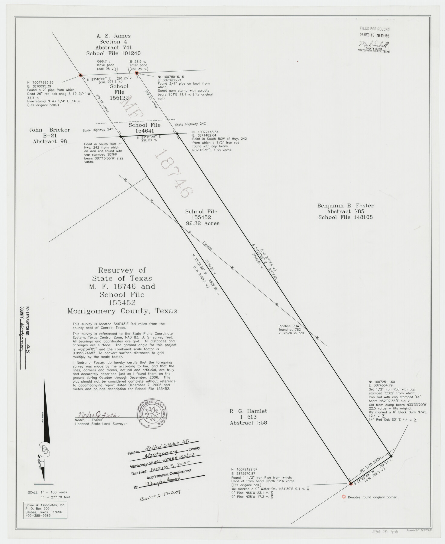
Montgomery County Rolled Sketch 46
Resurvey of State of Texas MF-18746 and School File 155452, Montgomery County, Texas
-
Map/Doc
87940
-
Collection
General Map Collection
-
Object Dates
2006/12/7 (Creation Date)
2007/8/9 (File Date)
-
People and Organizations
Nedra J. Foster (Surveyor/Engineer)
-
Counties
Montgomery
-
Subjects
Surveying Rolled Sketch
-
Height x Width
28.2 x 23.0 inches
71.6 x 58.4 cm
-
Medium
mylar, print
-
Scale
1" = 100 varas
-
Comments
See School File 155452 for surveyor's report.
Part of: General Map Collection
Current Miscellaneous File 15

Print $16.00
- Digital $50.00
Current Miscellaneous File 15
1951
Size 10.7 x 8.2 inches
Map/Doc 73822
Flight Mission No. CGI-1N, Frame 173, Cameron County

Print $20.00
- Digital $50.00
Flight Mission No. CGI-1N, Frame 173, Cameron County
1955
Size 18.5 x 22.1 inches
Map/Doc 84508
Blanco County Sketch File 35

Print $6.00
- Digital $50.00
Blanco County Sketch File 35
1890
Size 6.3 x 7.0 inches
Map/Doc 14639
Bell County Working Sketch 5

Print $20.00
- Digital $50.00
Bell County Working Sketch 5
1942
Size 26.9 x 21.0 inches
Map/Doc 67345
Flight Mission No. BQR-13K, Frame 25, Brazoria County

Print $20.00
- Digital $50.00
Flight Mission No. BQR-13K, Frame 25, Brazoria County
1952
Size 18.8 x 22.4 inches
Map/Doc 84073
[Map of Located Land of Gulf, Colorado & Santa Fe Ry. Co. through Denton]
![64340, [Map of Located Land of Gulf, Colorado & Santa Fe Ry. Co. through Denton], General Map Collection](https://historictexasmaps.com/wmedia_w700/maps/64340.tif.jpg)
Print $40.00
- Digital $50.00
[Map of Located Land of Gulf, Colorado & Santa Fe Ry. Co. through Denton]
Size 122.8 x 28.3 inches
Map/Doc 64340
Topographical Map of the Rio Grande from Roma to the Gulf of Mexico, Index Map, Sheet No. 2

Print $20.00
- Digital $50.00
Topographical Map of the Rio Grande from Roma to the Gulf of Mexico, Index Map, Sheet No. 2
1912
Map/Doc 89524
Armstrong County Sketch File 5

Print $40.00
- Digital $50.00
Armstrong County Sketch File 5
1887
Size 19.7 x 22.9 inches
Map/Doc 10841
Township No. 5 South Range No. 9 West of the Indian Meridian

Print $20.00
- Digital $50.00
Township No. 5 South Range No. 9 West of the Indian Meridian
1874
Size 19.2 x 24.5 inches
Map/Doc 75135
Jeff Davis County Working Sketch 45

Print $20.00
- Digital $50.00
Jeff Davis County Working Sketch 45
1990
Size 27.8 x 38.1 inches
Map/Doc 66540
Flight Mission No. CRC-4R, Frame 66, Chambers County

Print $20.00
- Digital $50.00
Flight Mission No. CRC-4R, Frame 66, Chambers County
1956
Size 18.6 x 22.5 inches
Map/Doc 84870
Hardeman County Working Sketch 4

Print $40.00
- Digital $50.00
Hardeman County Working Sketch 4
1920
Size 23.9 x 70.2 inches
Map/Doc 63385
You may also like
Culberson County Sketch File WJ

Print $8.00
- Digital $50.00
Culberson County Sketch File WJ
Size 14.2 x 28.2 inches
Map/Doc 5786
[Surveys near the Sabine River]
![302, [Surveys near the Sabine River], General Map Collection](https://historictexasmaps.com/wmedia_w700/maps/302.tif.jpg)
Print $20.00
- Digital $50.00
[Surveys near the Sabine River]
1840
Size 18.8 x 20.9 inches
Map/Doc 302
DeWitt County Working Sketch 13

Print $20.00
- Digital $50.00
DeWitt County Working Sketch 13
1986
Size 37.6 x 40.9 inches
Map/Doc 68603
2nd Chain to Long Reef, Texas

Print $40.00
- Digital $50.00
2nd Chain to Long Reef, Texas
1860
Size 30.9 x 52.6 inches
Map/Doc 69984
Treaty to Resolve Pending Boundary Differences and Maintain the Rio Grande and Colorado River as the International Boundary Between the United States of American and Mexico

Print $20.00
- Digital $50.00
Treaty to Resolve Pending Boundary Differences and Maintain the Rio Grande and Colorado River as the International Boundary Between the United States of American and Mexico
1970
Size 10.8 x 29.8 inches
Map/Doc 83106
El Paso County Working Sketch 25

Print $20.00
- Digital $50.00
El Paso County Working Sketch 25
1962
Size 42.7 x 41.9 inches
Map/Doc 69047
Flight Mission No. DCL-6C, Frame 116, Kenedy County

Print $20.00
- Digital $50.00
Flight Mission No. DCL-6C, Frame 116, Kenedy County
1943
Size 18.6 x 22.2 inches
Map/Doc 85946
Trinity River, Watershed

Print $20.00
- Digital $50.00
Trinity River, Watershed
1925
Size 46.9 x 40.5 inches
Map/Doc 65255
Travis County Sketch File 56

Print $6.00
- Digital $50.00
Travis County Sketch File 56
1945
Size 14.2 x 9.0 inches
Map/Doc 38398
Travis County State Real Property Sketch 4

Print $20.00
- Digital $50.00
Travis County State Real Property Sketch 4
1987
Size 25.7 x 30.7 inches
Map/Doc 61695
Franklin County Sketch File 4

Print $6.00
- Digital $50.00
Franklin County Sketch File 4
1855
Size 13.4 x 11.4 inches
Map/Doc 23015
[Surveys in Austin's Colony along the east bank of the Navidad River]
![78488, [Surveys in Austin's Colony along the east bank of the Navidad River], General Map Collection](https://historictexasmaps.com/wmedia_w700/maps/78488.tif.jpg)
Print $20.00
- Digital $50.00
[Surveys in Austin's Colony along the east bank of the Navidad River]
1827
Size 20.3 x 16.1 inches
Map/Doc 78488