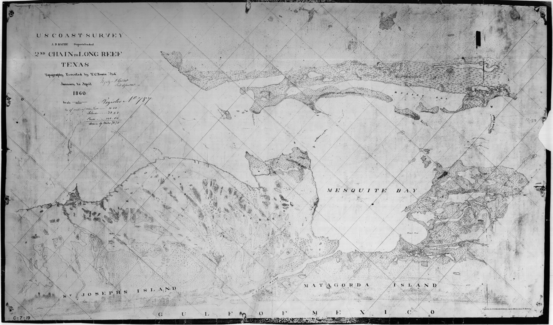
2nd Chain to Long Reef, Texas
C-7-19
-
Map/Doc
69984
-
Collection
General Map Collection
-
Object Dates
1860 (Creation Date)
-
Counties
Calhoun Aransas
-
Subjects
Nautical Charts
-
Height x Width
30.9 x 52.6 inches
78.5 x 133.6 cm
Part of: General Map Collection
Presidio County Rolled Sketch 26

Print $20.00
- Digital $50.00
Presidio County Rolled Sketch 26
1886
Size 33.9 x 26.9 inches
Map/Doc 7333
Nueces County Rolled Sketch 126 A-G

Print $22.00
- Digital $50.00
Nueces County Rolled Sketch 126 A-G
1998
Size 11.3 x 8.8 inches
Map/Doc 8962
Map of Brewster Co.

Print $40.00
- Digital $50.00
Map of Brewster Co.
1896
Size 58.4 x 17.3 inches
Map/Doc 4892
Baylor County Sketch File 19

Print $4.00
- Digital $50.00
Baylor County Sketch File 19
1885
Size 11.5 x 8.8 inches
Map/Doc 14193
Maps of Gulf Intracoastal Waterway, Texas - Sabine River to the Rio Grande and connecting waterways including ship channels

Print $20.00
- Digital $50.00
Maps of Gulf Intracoastal Waterway, Texas - Sabine River to the Rio Grande and connecting waterways including ship channels
1966
Size 14.6 x 22.2 inches
Map/Doc 61952
Reeves County Sketch File 15

Print $28.00
- Digital $50.00
Reeves County Sketch File 15
1879
Size 13.1 x 8.2 inches
Map/Doc 35194
Hudspeth County Working Sketch 31

Print $40.00
- Digital $50.00
Hudspeth County Working Sketch 31
1972
Size 56.2 x 41.2 inches
Map/Doc 66314
Gray County Working Sketch 3

Print $20.00
- Digital $50.00
Gray County Working Sketch 3
1958
Size 36.4 x 31.8 inches
Map/Doc 63234
Flight Mission No. BRE-1P, Frame 106, Nueces County

Print $20.00
- Digital $50.00
Flight Mission No. BRE-1P, Frame 106, Nueces County
1956
Size 18.6 x 22.6 inches
Map/Doc 86677
Concho, San Saba & Llano Valley Railway, Sterling City Branch, Texas. Right of Way and Track Map

Print $40.00
- Digital $50.00
Concho, San Saba & Llano Valley Railway, Sterling City Branch, Texas. Right of Way and Track Map
1910
Size 17.9 x 120.8 inches
Map/Doc 64436
Burnet County Boundary File 5

Print $16.00
- Digital $50.00
Burnet County Boundary File 5
Size 12.7 x 7.9 inches
Map/Doc 50878
Flight Mission No. CRC-3R, Frame 18, Chambers County

Print $20.00
- Digital $50.00
Flight Mission No. CRC-3R, Frame 18, Chambers County
1956
Size 18.7 x 22.4 inches
Map/Doc 84792
You may also like
Willacy County Boundary File 2

Print $16.00
- Digital $50.00
Willacy County Boundary File 2
Size 11.0 x 8.7 inches
Map/Doc 59967
Newton County

Print $20.00
- Digital $50.00
Newton County
1946
Size 46.8 x 40.9 inches
Map/Doc 77383

Llano County Working Sketch 8

Print $20.00
- Digital $50.00
Llano County Working Sketch 8
1978
Size 33.4 x 30.7 inches
Map/Doc 70626
Kinney County Working Sketch 42

Print $20.00
- Digital $50.00
Kinney County Working Sketch 42
1973
Size 20.4 x 33.7 inches
Map/Doc 70224
Sherman County

Print $20.00
- Digital $50.00
Sherman County
1932
Size 39.8 x 37.3 inches
Map/Doc 95640
Dimmit County, Texas

Print $20.00
- Digital $50.00
Dimmit County, Texas
1879
Size 22.6 x 28.6 inches
Map/Doc 5031
Right of Way & Track Map Houston & Brazos Valley Ry. operated by Houston & Brazos Valley Ry. Co., Hoskins Mound Branch

Print $40.00
- Digital $50.00
Right of Way & Track Map Houston & Brazos Valley Ry. operated by Houston & Brazos Valley Ry. Co., Hoskins Mound Branch
1924
Size 25.0 x 56.6 inches
Map/Doc 64610
Seagraves, Gaines County, Texas, Located in Surveys 10 and 15, Block C-34

Print $20.00
- Digital $50.00
Seagraves, Gaines County, Texas, Located in Surveys 10 and 15, Block C-34
Size 33.3 x 23.8 inches
Map/Doc 92687
Murphy and Bolanz' Index Map of Greater Dallas

Print $20.00
- Digital $50.00
Murphy and Bolanz' Index Map of Greater Dallas
1911
Size 20.3 x 18.3 inches
Map/Doc 96794
Carte Nouvelle de la Mer du Sud

Print $20.00
- Digital $50.00
Carte Nouvelle de la Mer du Sud
1730
Size 25.8 x 39.6 inches
Map/Doc 93824
Mapa de Texas con partes de los Estados Adyacentes

Mapa de Texas con partes de los Estados Adyacentes
1832
Size 6.8 x 5.7 inches
Map/Doc 94560