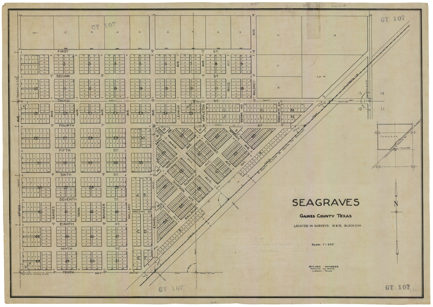
Seagraves, Gaines County, Texas, Located in Surveys 10 and 15, Block C-34
GT107
-
Map/Doc
92687
-
Collection
Twichell Survey Records
-
People and Organizations
Sylvan Sanders (Surveyor/Engineer)
-
Counties
Gaines
-
Height x Width
33.3 x 23.8 inches
84.6 x 60.5 cm
Part of: Twichell Survey Records
Working Sketch Compiled from Original Field Showing Surveys in Irion County Located by J. A. McDonald in 1856 and 1858

Print $20.00
- Digital $50.00
Working Sketch Compiled from Original Field Showing Surveys in Irion County Located by J. A. McDonald in 1856 and 1858
Size 13.1 x 13.8 inches
Map/Doc 92191
Agua Fria Quadrangle

Print $20.00
- Digital $50.00
Agua Fria Quadrangle
1917
Size 17.2 x 21.1 inches
Map/Doc 90136
[H. & T. C. Blocks 3 and 4; G. H. & S. A Blocks 2, 4, and 12; D. & P. Block 3]
![91027, [H. & T. C. Blocks 3 and 4; G. H. & S. A Blocks 2, 4, and 12; D. & P. Block 3], Twichell Survey Records](https://historictexasmaps.com/wmedia_w700/maps/91027-1.tif.jpg)
Print $20.00
- Digital $50.00
[H. & T. C. Blocks 3 and 4; G. H. & S. A Blocks 2, 4, and 12; D. & P. Block 3]
Size 44.6 x 36.3 inches
Map/Doc 91027
[Map showing State Capitol Lands]
![93143, [Map showing State Capitol Lands], Twichell Survey Records](https://historictexasmaps.com/wmedia_w700/maps/93143-1.tif.jpg)
Print $40.00
- Digital $50.00
[Map showing State Capitol Lands]
Size 50.6 x 65.3 inches
Map/Doc 93143
Map of the CB Live Stock Co. -N- Ranch situated in Crosby County, Texas

Print $20.00
- Digital $50.00
Map of the CB Live Stock Co. -N- Ranch situated in Crosby County, Texas
Size 21.2 x 38.1 inches
Map/Doc 90332
The American Tribune New Colony Company's Lands in Archer County, Texas

Print $20.00
- Digital $50.00
The American Tribune New Colony Company's Lands in Archer County, Texas
Size 42.9 x 37.5 inches
Map/Doc 89742
[Fisher County School Land Lgs. 106-108]
![90198, [Fisher County School Land Lgs. 106-108], Twichell Survey Records](https://historictexasmaps.com/wmedia_w700/maps/90198-1.tif.jpg)
Print $20.00
- Digital $50.00
[Fisher County School Land Lgs. 106-108]
Size 11.7 x 18.4 inches
Map/Doc 90198
Gaines County

Print $40.00
- Digital $50.00
Gaines County
1902
Size 49.7 x 38.6 inches
Map/Doc 89863
Double Lakes No. 1, T-Ranch

Print $20.00
- Digital $50.00
Double Lakes No. 1, T-Ranch
Size 37.1 x 34.0 inches
Map/Doc 92944
[Sections 155-162, Toyah Creek Irrigation Company and surrounding surveys]
![91037, [Sections 155-162, Toyah Creek Irrigation Company and surrounding surveys], Twichell Survey Records](https://historictexasmaps.com/wmedia_w700/maps/91037-1.tif.jpg)
Print $20.00
- Digital $50.00
[Sections 155-162, Toyah Creek Irrigation Company and surrounding surveys]
1916
Size 12.8 x 38.7 inches
Map/Doc 91037
A Map of California with Descriptive Notes

A Map of California with Descriptive Notes
1954
Size 29.5 x 37.6 inches
Map/Doc 92394
[Map showing Jno. H. Gibson Block D]
![92005, [Map showing Jno. H. Gibson Block D], Twichell Survey Records](https://historictexasmaps.com/wmedia_w700/maps/92005-1.tif.jpg)
Print $20.00
- Digital $50.00
[Map showing Jno. H. Gibson Block D]
Size 18.3 x 15.9 inches
Map/Doc 92005
You may also like
Marion County Sketch File 8

Print $4.00
- Digital $50.00
Marion County Sketch File 8
1852
Size 10.0 x 8.1 inches
Map/Doc 30575
Gaines County Rolled Sketch 30

Print $20.00
- Digital $50.00
Gaines County Rolled Sketch 30
1962
Size 19.4 x 26.3 inches
Map/Doc 5943
General Highway Map, Upton County, Texas

Print $20.00
General Highway Map, Upton County, Texas
1961
Size 24.7 x 18.1 inches
Map/Doc 79693
Sheet 6 copied from Champlin Book 5 [Strip Map showing T. & P. connecting lines]
![93175, Sheet 6 copied from Champlin Book 5 [Strip Map showing T. & P. connecting lines], Twichell Survey Records](https://historictexasmaps.com/wmedia_w700/maps/93175-1.tif.jpg)
Print $40.00
- Digital $50.00
Sheet 6 copied from Champlin Book 5 [Strip Map showing T. & P. connecting lines]
1909
Size 7.7 x 90.0 inches
Map/Doc 93175
Capitol Syndicate Subdivision of Capitol Land Reservation Leagues Number 153, 154, 155, 156, 157, 158, 167, 168, 169, 170, 171, and 172 and Parts of Leagues 143, 144, 145, 146, 152, 159, 166, and 173

Print $20.00
- Digital $50.00
Capitol Syndicate Subdivision of Capitol Land Reservation Leagues Number 153, 154, 155, 156, 157, 158, 167, 168, 169, 170, 171, and 172 and Parts of Leagues 143, 144, 145, 146, 152, 159, 166, and 173
1908
Size 22.8 x 34.6 inches
Map/Doc 90735
Map of the Hearne and Brazos Valley Railroad from Mumford to Moseley's Ferry

Print $40.00
- Digital $50.00
Map of the Hearne and Brazos Valley Railroad from Mumford to Moseley's Ferry
1892
Size 20.0 x 56.8 inches
Map/Doc 64400
Flight Mission No. DAH-9M, Frame 200, Orange County

Print $20.00
- Digital $50.00
Flight Mission No. DAH-9M, Frame 200, Orange County
1953
Size 18.6 x 22.4 inches
Map/Doc 86868
Town of Ropes Hockley County, Texas

Print $20.00
- Digital $50.00
Town of Ropes Hockley County, Texas
Size 29.5 x 29.8 inches
Map/Doc 92223
Jack County Sketch File 3

Print $6.00
- Digital $50.00
Jack County Sketch File 3
1857
Size 10.6 x 16.5 inches
Map/Doc 27504
Kenedy County Rolled Sketch 11

Print $20.00
- Digital $50.00
Kenedy County Rolled Sketch 11
1938
Size 40.5 x 30.2 inches
Map/Doc 6471
[Map showing Jno. H. Gibson Block D]
![92001, [Map showing Jno. H. Gibson Block D], Twichell Survey Records](https://historictexasmaps.com/wmedia_w700/maps/92001-1.tif.jpg)
Print $20.00
- Digital $50.00
[Map showing Jno. H. Gibson Block D]
Size 17.9 x 15.0 inches
Map/Doc 92001
Jeff Davis County Rolled Sketch 20

Print $20.00
- Digital $50.00
Jeff Davis County Rolled Sketch 20
1944
Size 22.7 x 19.6 inches
Map/Doc 7724