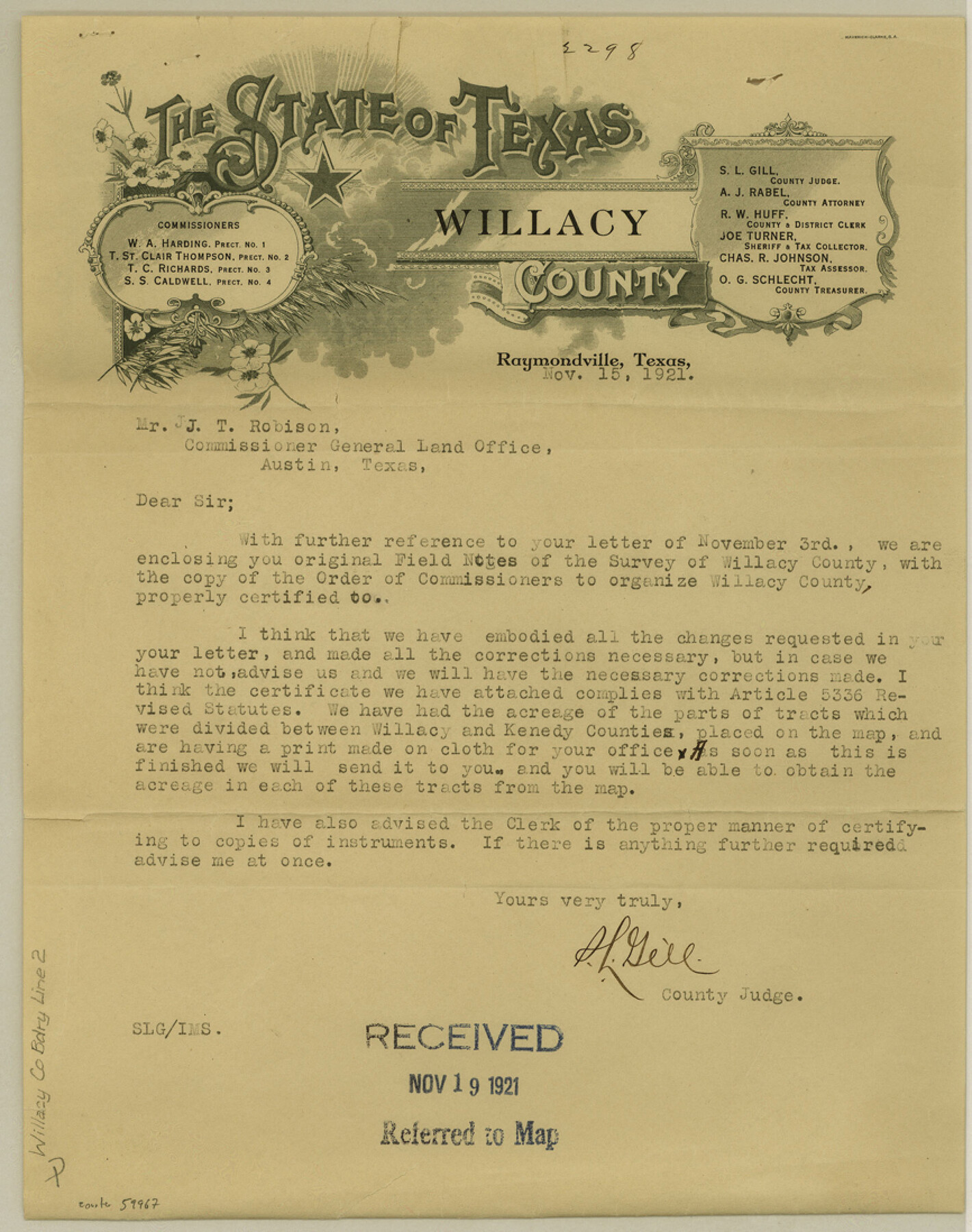
Willacy County Boundary File 2
Field Notes Willacy County
-
Map/Doc
59967
-
Collection
General Map Collection
-
Counties
Willacy
-
Subjects
County Boundaries
-
Height x Width
11.0 x 8.7 inches
27.9 x 22.1 cm
Part of: General Map Collection
Sectional Map No. 5 of the lands and of the line of the Texas & Pacific Ry. Co. in part of El Paso County

Print $20.00
- Digital $50.00
Sectional Map No. 5 of the lands and of the line of the Texas & Pacific Ry. Co. in part of El Paso County
1885
Size 22.5 x 17.9 inches
Map/Doc 2305
[Capitol Leagues in Oldham County]
![4506, [Capitol Leagues in Oldham County], General Map Collection](https://historictexasmaps.com/wmedia_w700/maps/4506-1.tif.jpg)
Print $20.00
- Digital $50.00
[Capitol Leagues in Oldham County]
1918
Size 37.9 x 30.4 inches
Map/Doc 4506
A map of Lewis and Clark's track across the western portion of North America from the Mississippi to the Pacific Ocean, by Order of the executive of the United States in 1804, 5, & 6

Print $20.00
- Digital $50.00
A map of Lewis and Clark's track across the western portion of North America from the Mississippi to the Pacific Ocean, by Order of the executive of the United States in 1804, 5, & 6
1814
Size 13.3 x 27.9 inches
Map/Doc 97412
Hardin County Working Sketch 8

Print $20.00
- Digital $50.00
Hardin County Working Sketch 8
1926
Size 16.5 x 21.0 inches
Map/Doc 63406
Runnels County Rolled Sketch 40

Print $20.00
- Digital $50.00
Runnels County Rolled Sketch 40
Size 32.3 x 38.9 inches
Map/Doc 7528

Nueces County Rolled Sketch 94

Print $108.00
Nueces County Rolled Sketch 94
1983
Size 24.2 x 36.6 inches
Map/Doc 7044
Port Aransas-Corpus Christi Waterway, Texas, Avery Point Turning Basin to Vicinity of Tule Lake - Dredging

Print $20.00
- Digital $50.00
Port Aransas-Corpus Christi Waterway, Texas, Avery Point Turning Basin to Vicinity of Tule Lake - Dredging
1947
Size 28.5 x 41.4 inches
Map/Doc 60301
Jeff Davis County Sketch File 47

Print $4.00
- Digital $50.00
Jeff Davis County Sketch File 47
1996
Size 4.3 x 9.7 inches
Map/Doc 28084
Grayson County Sketch File 13

Print $40.00
- Digital $50.00
Grayson County Sketch File 13
1853
Size 16.2 x 14.4 inches
Map/Doc 24480
Tarrant County Working Sketch 10

Print $40.00
- Digital $50.00
Tarrant County Working Sketch 10
1986
Size 29.4 x 58.0 inches
Map/Doc 62427

You may also like


Blanco County Sketch File 12

Print $20.00
- Digital $50.00
Blanco County Sketch File 12
Size 15.0 x 19.8 inches
Map/Doc 10928
Harris County Working Sketch 3

Print $20.00
- Digital $50.00
Harris County Working Sketch 3
Size 14.7 x 22.4 inches
Map/Doc 65895

Flight Mission No. DQN-2K, Frame 2, Calhoun County

Print $20.00
- Digital $50.00
Flight Mission No. DQN-2K, Frame 2, Calhoun County
1953
Size 18.6 x 22.3 inches
Map/Doc 84219
Potter County

Print $20.00
- Digital $50.00
Potter County
1960
Size 40.0 x 32.3 inches
Map/Doc 77397
Johnson County Working Sketch 2

Print $20.00
- Digital $50.00
Johnson County Working Sketch 2
Size 20.8 x 20.2 inches
Map/Doc 66615
Sketch in Terry and Yoakum Counties

Print $20.00
- Digital $50.00
Sketch in Terry and Yoakum Counties
1945
Size 20.7 x 38.5 inches
Map/Doc 91939
Eastland County Rolled Sketch 26

Print $20.00
- Digital $50.00
Eastland County Rolled Sketch 26
1918
Size 23.2 x 17.9 inches
Map/Doc 5777
Bell County Sketch File 11

Print $4.00
- Digital $50.00
Bell County Sketch File 11
1852
Size 9.9 x 7.8 inches
Map/Doc 14383
Flight Mission No. BQR-5K, Frame 73, Brazoria County

Print $20.00
- Digital $50.00
Flight Mission No. BQR-5K, Frame 73, Brazoria County
1952
Size 19.1 x 22.6 inches
Map/Doc 84018