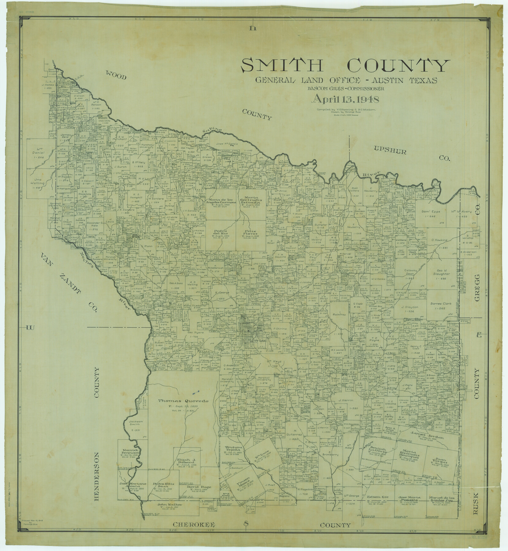
Smith County
-
Map/Doc
63039
-
Collection
General Map Collection
-
Object Dates
1948/4/13 (Creation Date)
-
People and Organizations
Texas General Land Office (Publisher)
Tommye Buie (Draftsman)
Bascom Giles (GLO Commissioner)
Victor E. Sterzing (Compiler)
R.C. Wisdom (Compiler)
-
Counties
Smith
-
Subjects
County
-
Height x Width
45.9 x 42.2 inches
116.6 x 107.2 cm
-
Comments
Traced March 19, 1949 by Tommye Buie.
Part of: General Map Collection
Karnes County Rolled Sketch 3

Print $20.00
- Digital $50.00
Karnes County Rolled Sketch 3
1959
Size 27.9 x 41.6 inches
Map/Doc 6454
United States - Gulf Coast Texas - Southern part of Laguna Madre

Print $20.00
- Digital $50.00
United States - Gulf Coast Texas - Southern part of Laguna Madre
1941
Size 26.5 x 18.3 inches
Map/Doc 72955
[Surveys in the Travis District along the Colorado River]
![3180, [Surveys in the Travis District along the Colorado River], General Map Collection](https://historictexasmaps.com/wmedia_w700/maps/3180.tif.jpg)
Print $2.00
- Digital $50.00
[Surveys in the Travis District along the Colorado River]
1841
Size 7.0 x 7.3 inches
Map/Doc 3180
Hudspeth County Working Sketch 40

Print $20.00
- Digital $50.00
Hudspeth County Working Sketch 40
1981
Size 35.6 x 43.8 inches
Map/Doc 66325
Polk County Sketch File 21

Print $8.00
- Digital $50.00
Polk County Sketch File 21
Size 12.9 x 8.3 inches
Map/Doc 34169
Current Miscellaneous File 40

Print $10.00
- Digital $50.00
Current Miscellaneous File 40
Size 14.2 x 8.7 inches
Map/Doc 73972
Brazoria County NRC Article 33.136 Sketch 34

Print $24.00
Brazoria County NRC Article 33.136 Sketch 34
2025
Map/Doc 97478
Harris County Working Sketch 34

Print $40.00
- Digital $50.00
Harris County Working Sketch 34
1937
Size 37.5 x 52.1 inches
Map/Doc 65926
Donley County Sketch File 18 (2a)

Print $2.00
- Digital $50.00
Donley County Sketch File 18 (2a)
Size 10.3 x 8.0 inches
Map/Doc 21255
Bowie County Rolled Sketch 6

Print $20.00
- Digital $50.00
Bowie County Rolled Sketch 6
1992
Size 11.3 x 18.1 inches
Map/Doc 5161
[Sketch for Mineral Application 16696-16697, Pecos River]
![65612, [Sketch for Mineral Application 16696-16697, Pecos River], General Map Collection](https://historictexasmaps.com/wmedia_w700/maps/65612-1.tif.jpg)
Print $40.00
- Digital $50.00
[Sketch for Mineral Application 16696-16697, Pecos River]
Size 37.4 x 74.9 inches
Map/Doc 65612
Layout of the porciones as described in the Visita General of Laredo, 1767

Layout of the porciones as described in the Visita General of Laredo, 1767
2009
Size 11.0 x 8.5 inches
Map/Doc 94042
You may also like
Crockett County Rolled Sketch 88M

Print $20.00
- Digital $50.00
Crockett County Rolled Sketch 88M
1964
Size 25.2 x 34.2 inches
Map/Doc 5629
Chambers County Rolled Sketch 8

Print $20.00
- Digital $50.00
Chambers County Rolled Sketch 8
Size 39.8 x 30.5 inches
Map/Doc 8612
Flight Mission No. BRE-2P, Frame 70, Nueces County

Print $20.00
- Digital $50.00
Flight Mission No. BRE-2P, Frame 70, Nueces County
1956
Size 18.5 x 22.6 inches
Map/Doc 86765
Hidalgo County Sketch File 14

Print $20.00
- Digital $50.00
Hidalgo County Sketch File 14
Size 29.6 x 24.5 inches
Map/Doc 11764
Flight Mission No. CLL-1N, Frame 159, Willacy County

Print $20.00
- Digital $50.00
Flight Mission No. CLL-1N, Frame 159, Willacy County
1954
Size 18.4 x 22.2 inches
Map/Doc 87050
Lampasas County Boundary File 12

Print $6.00
- Digital $50.00
Lampasas County Boundary File 12
Size 11.0 x 8.6 inches
Map/Doc 56191
Coleman County Working Sketch 8

Print $20.00
- Digital $50.00
Coleman County Working Sketch 8
1946
Size 39.3 x 33.3 inches
Map/Doc 68074
Roberts County Boundary File 1

Print $40.00
- Digital $50.00
Roberts County Boundary File 1
Size 14.4 x 8.9 inches
Map/Doc 58313
Sketch Showing Township 5 North, T. & P. RR. Surveys, Borden and Dawson Counties, Texas

Print $20.00
- Digital $50.00
Sketch Showing Township 5 North, T. & P. RR. Surveys, Borden and Dawson Counties, Texas
Size 24.7 x 36.0 inches
Map/Doc 90636
Burleson County Sketch File 9

Print $12.00
- Digital $50.00
Burleson County Sketch File 9
1929
Size 14.2 x 8.1 inches
Map/Doc 16657
English Field Notes of the Spanish Archives - Book Lockhart

English Field Notes of the Spanish Archives - Book Lockhart
1832
Map/Doc 96539
King County Working Sketch 15

Print $40.00
- Digital $50.00
King County Working Sketch 15
1979
Size 41.6 x 60.4 inches
Map/Doc 70179