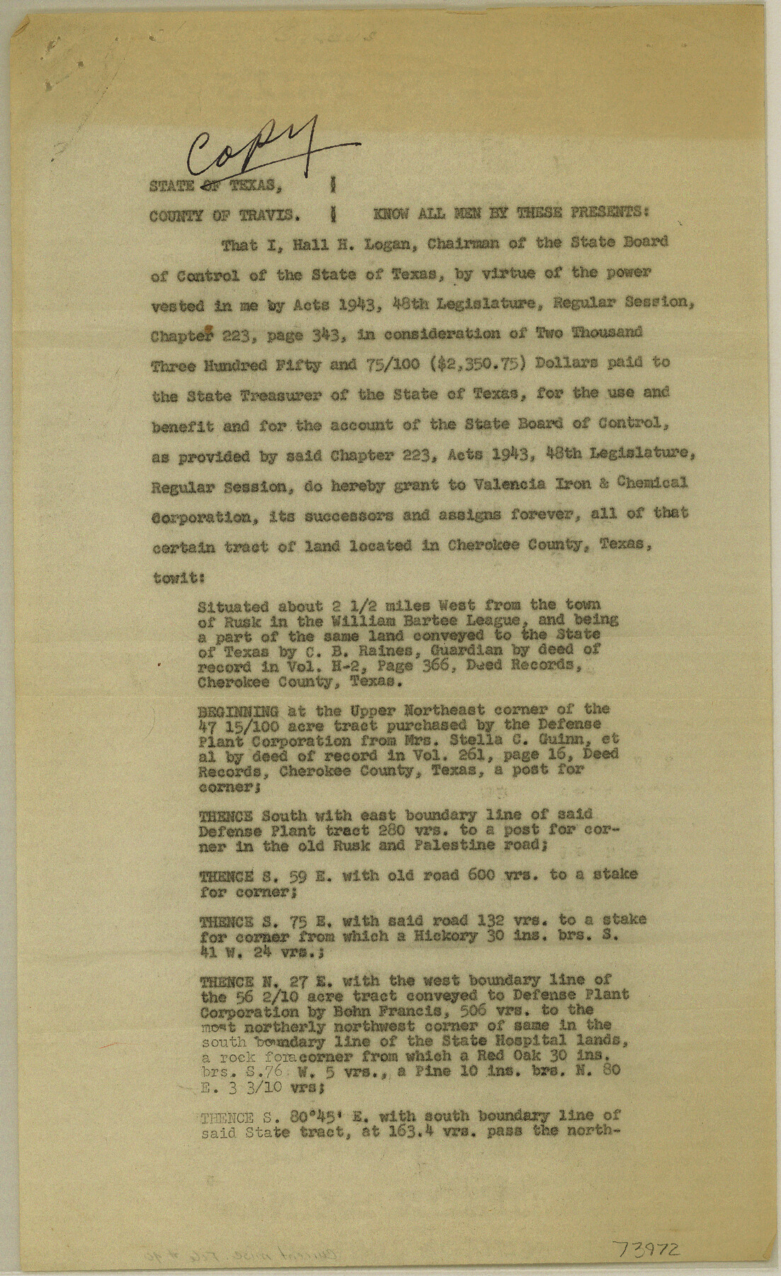
Current Miscellaneous File 40
Sale of 83.63 acres of land out of Wm. Bartee League, Cherokee County to Valencia Iron and Chemical Corp as provided by Charter 223, Acts 1943, 48th Legislature, Regular Session
-
Map/Doc
73972
-
Collection
General Map Collection
-
Subjects
Legal
-
Height x Width
14.2 x 8.7 inches
36.1 x 22.1 cm
Part of: General Map Collection
San Patricio County

Print $40.00
- Digital $50.00
San Patricio County
1939
Size 40.3 x 49.3 inches
Map/Doc 95634
Intracoastal Waterway in Texas - Corpus Christi to Point Isabel including Arroyo Colorado to Mo. Pac. R.R. Bridge Near Harlingen

Print $20.00
- Digital $50.00
Intracoastal Waterway in Texas - Corpus Christi to Point Isabel including Arroyo Colorado to Mo. Pac. R.R. Bridge Near Harlingen
1934
Size 21.9 x 33.5 inches
Map/Doc 61882
Dallas County Working Sketch 12

Print $20.00
- Digital $50.00
Dallas County Working Sketch 12
1983
Size 30.5 x 44.1 inches
Map/Doc 68578
Reagan County Rolled Sketch 30

Print $20.00
- Digital $50.00
Reagan County Rolled Sketch 30
Size 32.7 x 28.5 inches
Map/Doc 7446
Flight Mission No. BQY-15M, Frame 12, Harris County

Print $20.00
- Digital $50.00
Flight Mission No. BQY-15M, Frame 12, Harris County
1953
Size 18.7 x 22.4 inches
Map/Doc 85310
Representation of surveys on the waters of the Paluxy and Bosque in the crosstimbers in Milam District

Print $2.00
- Digital $50.00
Representation of surveys on the waters of the Paluxy and Bosque in the crosstimbers in Milam District
1847
Size 13.9 x 8.0 inches
Map/Doc 258
Dallas County Working Sketch 6

Print $20.00
- Digital $50.00
Dallas County Working Sketch 6
1947
Size 16.7 x 25.9 inches
Map/Doc 68572
Johnson County Sketch File 3

Print $4.00
- Digital $50.00
Johnson County Sketch File 3
Size 10.1 x 8.0 inches
Map/Doc 28433
Nueces County Rolled Sketch 43A

Print $20.00
- Digital $50.00
Nueces County Rolled Sketch 43A
Size 24.0 x 35.4 inches
Map/Doc 6884
East Part of Liberty Co.

Print $20.00
- Digital $50.00
East Part of Liberty Co.
1977
Size 46.1 x 35.9 inches
Map/Doc 73219
Sherman County Rolled Sketch 12

Print $40.00
- Digital $50.00
Sherman County Rolled Sketch 12
1951
Size 63.9 x 11.3 inches
Map/Doc 10611
Waller County Boundary File 1

Print $8.00
- Digital $50.00
Waller County Boundary File 1
Size 11.4 x 8.9 inches
Map/Doc 59663
You may also like
E. B. Shipp Irrigated Farm East Part Section 32, Block JS

Print $3.00
- Digital $50.00
E. B. Shipp Irrigated Farm East Part Section 32, Block JS
Size 9.3 x 16.7 inches
Map/Doc 92298
Falls County Sketch File 13

Print $4.00
- Digital $50.00
Falls County Sketch File 13
1870
Size 10.3 x 8.7 inches
Map/Doc 22368
Current Miscellaneous File 50

Print $30.00
- Digital $50.00
Current Miscellaneous File 50
Size 11.9 x 9.2 inches
Map/Doc 74014
Duval County Rolled Sketch 18

Print $20.00
- Digital $50.00
Duval County Rolled Sketch 18
1940
Size 23.7 x 23.0 inches
Map/Doc 5739
Culberson County Sketch File 5

Print $4.00
- Digital $50.00
Culberson County Sketch File 5
Size 9.4 x 8.2 inches
Map/Doc 20136
Bexar County Sketch File 58

Print $4.00
- Digital $50.00
Bexar County Sketch File 58
1847
Size 10.4 x 8.3 inches
Map/Doc 14572
Sutton County Sketch File JAC

Print $20.00
- Digital $50.00
Sutton County Sketch File JAC
Size 24.5 x 23.4 inches
Map/Doc 12398
Hardin County Sketch File 18

Print $6.00
- Digital $50.00
Hardin County Sketch File 18
1870
Size 9.8 x 8.6 inches
Map/Doc 25132
Caldwell County Sketch File 3

Print $4.00
- Digital $50.00
Caldwell County Sketch File 3
1872
Size 12.7 x 8.1 inches
Map/Doc 35827
San Saba County Sketch File 10

Print $20.00
- Digital $50.00
San Saba County Sketch File 10
1883
Size 20.4 x 16.5 inches
Map/Doc 12290
Crockett County Rolled Sketch 73

Print $20.00
- Digital $50.00
Crockett County Rolled Sketch 73
1949
Size 10.4 x 23.6 inches
Map/Doc 5614
Flight Mission No. BRE-2P, Frame 53, Nueces County

Print $20.00
- Digital $50.00
Flight Mission No. BRE-2P, Frame 53, Nueces County
1956
Size 18.4 x 22.2 inches
Map/Doc 86755