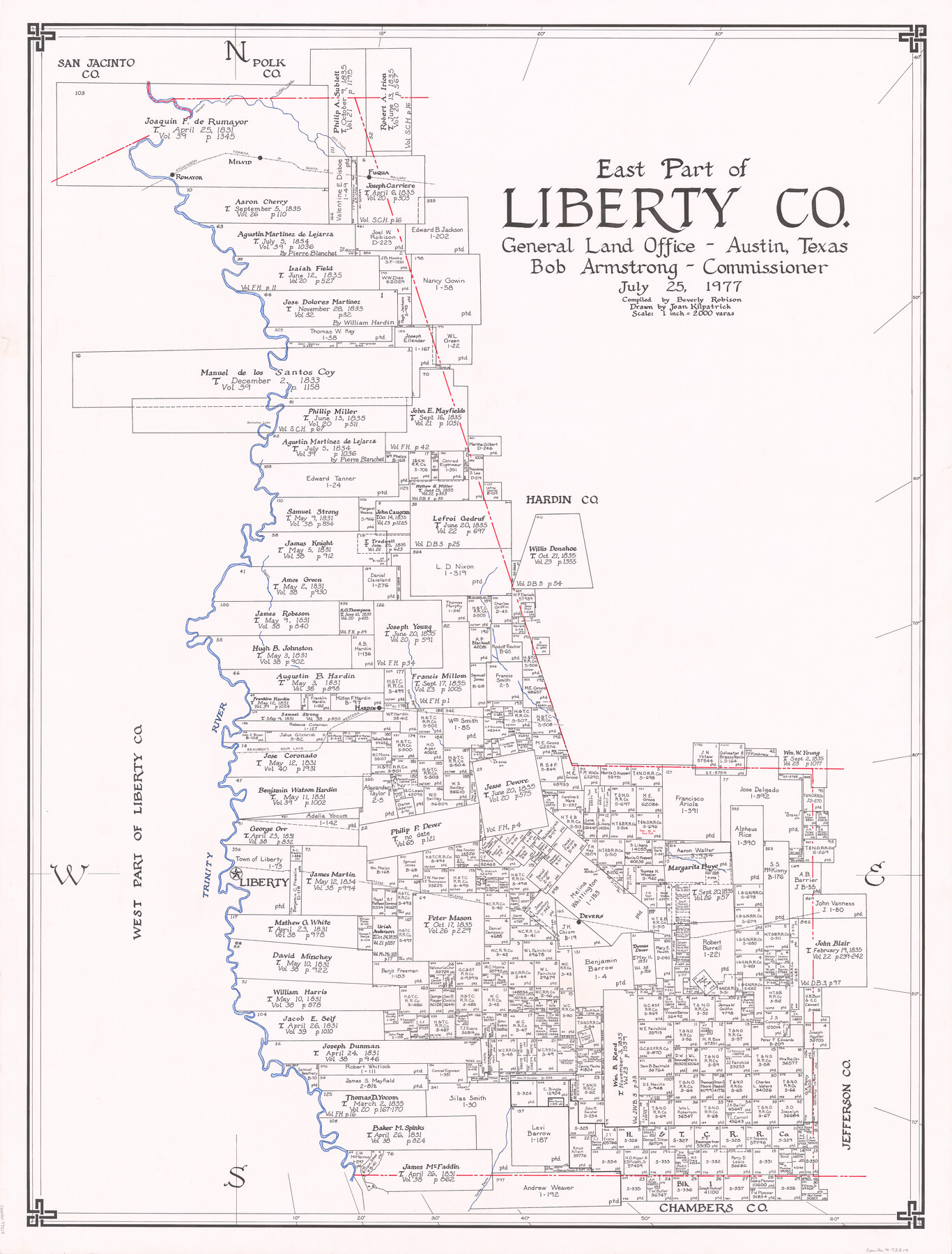
East Part of Liberty Co.
-
Map/Doc
73219
-
Collection
General Map Collection
-
Object Dates
7/25/1977 (Creation Date)
-
People and Organizations
Beverly Robison (Compiler)
Bob Armstrong (GLO Commissioner)
Joan Kilpatrick (Draftsman)
-
Counties
Liberty
-
Subjects
County
-
Height x Width
46.1 x 35.9 inches
117.1 x 91.2 cm
-
Scale
1" = 2000 varas
-
Comments
Hand lettered.
-
Features
Menard Creek
Indian Creek
Fuqua
Mill Creek
AT&SF
Milvid
Romayor
Horseshoe Lake
Turtle Bayou
Hardin
BSL&W
Trinity River
Liberty
Devers
T&NO
Part of: General Map Collection
Live Oak County Working Sketch 7

Print $20.00
- Digital $50.00
Live Oak County Working Sketch 7
1937
Size 24.9 x 37.6 inches
Map/Doc 70592
Hockley County

Print $20.00
- Digital $50.00
Hockley County
1914
Size 25.8 x 22.4 inches
Map/Doc 66866
Waller County

Print $20.00
- Digital $50.00
Waller County
1945
Size 46.4 x 27.1 inches
Map/Doc 77449
Ward County Working Sketch 31

Print $40.00
- Digital $50.00
Ward County Working Sketch 31
1967
Size 32.0 x 75.6 inches
Map/Doc 72337
Upshur County Sketch File 2

Print $4.00
- Digital $50.00
Upshur County Sketch File 2
1848
Size 8.5 x 11.0 inches
Map/Doc 38732
Schleicher County Sketch File 37

Print $20.00
- Digital $50.00
Schleicher County Sketch File 37
1952
Size 24.9 x 29.3 inches
Map/Doc 12310
Henderson County Sketch File 15

Print $4.00
- Digital $50.00
Henderson County Sketch File 15
1890
Size 8.1 x 13.1 inches
Map/Doc 26357
Hays County Working Sketch 13

Print $20.00
- Digital $50.00
Hays County Working Sketch 13
1952
Size 24.2 x 35.0 inches
Map/Doc 66087
Shackelford County Rolled Sketch 5

Print $20.00
- Digital $50.00
Shackelford County Rolled Sketch 5
1984
Size 23.1 x 37.1 inches
Map/Doc 7773

Map of section no. 5 of a survey of Padre Island made for the Office of the Attorney General of the State of Texas

Print $40.00
- Digital $50.00
Map of section no. 5 of a survey of Padre Island made for the Office of the Attorney General of the State of Texas
1941
Size 49.8 x 40.0 inches
Map/Doc 2261
Montgomery County Working Sketch 20

Print $20.00
- Digital $50.00
Montgomery County Working Sketch 20
1935
Size 27.8 x 38.9 inches
Map/Doc 71127
You may also like
Throckmorton County Sketch File 8

Print $66.00
- Digital $50.00
Throckmorton County Sketch File 8
Size 24.0 x 32.4 inches
Map/Doc 12433
Matagorda County Aerial Photograph Index Sheet 6

Print $20.00
- Digital $50.00
Matagorda County Aerial Photograph Index Sheet 6
1953
Size 23.8 x 19.6 inches
Map/Doc 83727
Jack County Working Sketch 17

Print $20.00
- Digital $50.00
Jack County Working Sketch 17
1982
Size 25.9 x 27.4 inches
Map/Doc 66443
[Nueces Bay Islands and Nesting Birds]
![60312, [Nueces Bay Islands and Nesting Birds], General Map Collection](https://historictexasmaps.com/wmedia_w700/maps/60312.tif.jpg)
Print $2.00
- Digital $50.00
[Nueces Bay Islands and Nesting Birds]
1940
Size 11.4 x 7.2 inches
Map/Doc 60312
Mills County Boundary File 7

Print $2.00
- Digital $50.00
Mills County Boundary File 7
Size 14.2 x 8.6 inches
Map/Doc 57312
Sketch showing parts of Terry, Yoakum, Hockley, Cochran Counties

Print $20.00
- Digital $50.00
Sketch showing parts of Terry, Yoakum, Hockley, Cochran Counties
Size 43.5 x 36.9 inches
Map/Doc 89883
Houston County Working Sketch 3

Print $20.00
- Digital $50.00
Houston County Working Sketch 3
Size 16.7 x 18.5 inches
Map/Doc 66233
San Jacinto County Sketch File 12a

Print $20.00
San Jacinto County Sketch File 12a
Size 12.8 x 14.3 inches
Map/Doc 35722
El Paso County Sketch File 10

Print $52.00
- Digital $50.00
El Paso County Sketch File 10
1890
Size 8.4 x 5.4 inches
Map/Doc 21974

Trinity River, Flagg Lake Sheet/Cedar Creek

Print $20.00
- Digital $50.00
Trinity River, Flagg Lake Sheet/Cedar Creek
1927
Size 37.4 x 30.7 inches
Map/Doc 65219
Map of the country scouted by Colonels McKenzie and Shafter, Capt. R.P. Wilson and others in the years, 1874 & 1875

Print $20.00
- Digital $50.00
Map of the country scouted by Colonels McKenzie and Shafter, Capt. R.P. Wilson and others in the years, 1874 & 1875
1876
Size 43.0 x 31.8 inches
Map/Doc 62972