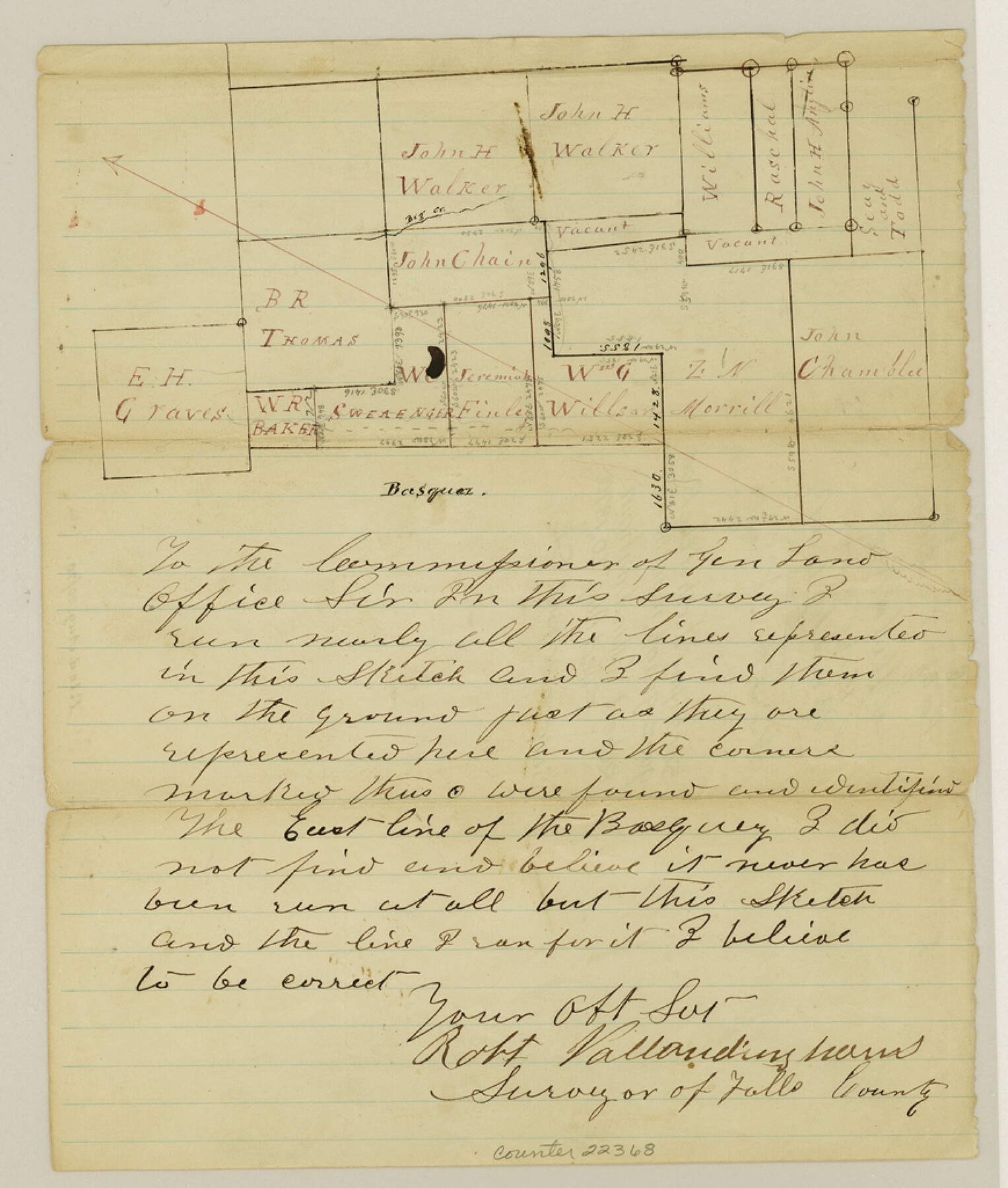
Falls County Sketch File 13
[Sketch of surveys lying north of the Basquez grant, near the northeast corner of county]
-
Map/Doc
22368
-
Collection
General Map Collection
-
Object Dates
1870/8/20 (Creation Date)
1870/8/20 (File Date)
-
People and Organizations
Robert Vallandingham (Surveyor/Engineer)
-
Counties
Falls
-
Subjects
Surveying Sketch File
-
Height x Width
10.3 x 8.7 inches
26.2 x 22.1 cm
-
Medium
paper, manuscript
-
Features
Big Creek
[Brushy Creek]
Part of: General Map Collection
Lamar County Sketch File 8

Print $20.00
- Digital $50.00
Lamar County Sketch File 8
1895
Size 21.4 x 23.1 inches
Map/Doc 11966
Travis County Working Sketch 38

Print $20.00
- Digital $50.00
Travis County Working Sketch 38
1974
Size 17.5 x 34.8 inches
Map/Doc 69422
Dickens County Working Sketch 12
Print $20.00
- Digital $50.00
Dickens County Working Sketch 12
1978
Size 28.3 x 28.9 inches
Map/Doc 68660
Roberts County Working Sketch 33

Print $20.00
- Digital $50.00
Roberts County Working Sketch 33
1978
Size 26.6 x 22.4 inches
Map/Doc 63559
Dimmit County Sketch File 32

Print $6.00
- Digital $50.00
Dimmit County Sketch File 32
1886
Size 13.9 x 8.7 inches
Map/Doc 21148
Stephens County Sketch File 11

Print $4.00
- Digital $50.00
Stephens County Sketch File 11
1882
Size 8.8 x 9.1 inches
Map/Doc 37055
Pecos County Working Sketch 45

Print $20.00
- Digital $50.00
Pecos County Working Sketch 45
1946
Size 20.8 x 26.7 inches
Map/Doc 71517
McMullen County Working Sketch 41

Print $20.00
- Digital $50.00
McMullen County Working Sketch 41
1978
Size 32.5 x 23.9 inches
Map/Doc 70742
Flight Mission No. CRE-1R, Frame 129, Jackson County

Print $20.00
- Digital $50.00
Flight Mission No. CRE-1R, Frame 129, Jackson County
1956
Size 18.5 x 22.3 inches
Map/Doc 85337
Titus County Working Sketch 1

Print $20.00
- Digital $50.00
Titus County Working Sketch 1
Size 18.2 x 17.3 inches
Map/Doc 69362
Hale County Sketch File 26

Print $40.00
- Digital $50.00
Hale County Sketch File 26
1911
Size 20.7 x 54.4 inches
Map/Doc 10471
Cameron County

Print $20.00
- Digital $50.00
Cameron County
1976
Size 30.9 x 38.1 inches
Map/Doc 77230
You may also like
West End of Copano Bay and Town of Saint Marys, Texas

Print $40.00
- Digital $50.00
West End of Copano Bay and Town of Saint Marys, Texas
1861
Size 54.5 x 32.9 inches
Map/Doc 73428
Flight Mission No. CUG-1P, Frame 22, Kleberg County

Print $20.00
- Digital $50.00
Flight Mission No. CUG-1P, Frame 22, Kleberg County
1956
Size 18.7 x 22.1 inches
Map/Doc 86112
Flight Mission No. CRC-5R, Frame 18, Chambers County

Print $20.00
- Digital $50.00
Flight Mission No. CRC-5R, Frame 18, Chambers County
1956
Size 18.7 x 22.4 inches
Map/Doc 84940
Current Miscellaneous File 15

Print $16.00
- Digital $50.00
Current Miscellaneous File 15
1951
Size 10.7 x 8.2 inches
Map/Doc 73822
Real County Working Sketch 14

Print $20.00
- Digital $50.00
Real County Working Sketch 14
1933
Size 30.2 x 30.5 inches
Map/Doc 71906
Uvalde County Sketch File 26-1

Print $6.00
- Digital $50.00
Uvalde County Sketch File 26-1
1930
Size 11.5 x 8.9 inches
Map/Doc 39013
Nolan County Sketch File 18

Print $8.00
- Digital $50.00
Nolan County Sketch File 18
Size 14.3 x 8.9 inches
Map/Doc 32489
Wichita County Sketch File 19

Print $20.00
- Digital $50.00
Wichita County Sketch File 19
Size 21.9 x 22.5 inches
Map/Doc 12681
Bandera County Working Sketch 9

Print $20.00
- Digital $50.00
Bandera County Working Sketch 9
1920
Size 15.2 x 17.1 inches
Map/Doc 67602
Coast Chart No. 212 - From Latitude 26° 33' to the Rio Grande, Texas

Print $20.00
- Digital $50.00
Coast Chart No. 212 - From Latitude 26° 33' to the Rio Grande, Texas
1886
Size 21.9 x 17.5 inches
Map/Doc 73505
Kinney County Working Sketch 36

Print $20.00
- Digital $50.00
Kinney County Working Sketch 36
1966
Size 31.7 x 42.0 inches
Map/Doc 70218
Reeves County Sketch File 27

Print $14.00
- Digital $50.00
Reeves County Sketch File 27
1982
Size 11.5 x 8.9 inches
Map/Doc 35228