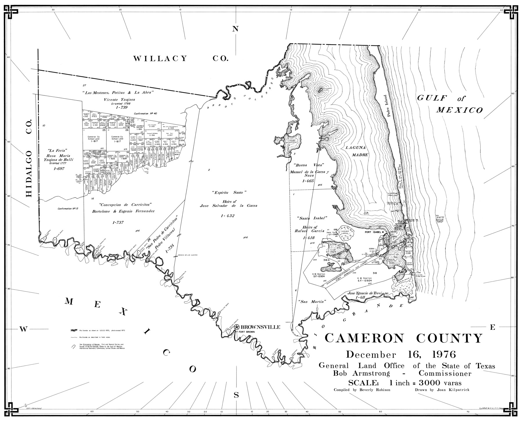
Cameron County
-
Map/Doc
77230
-
Collection
General Map Collection
-
Object Dates
12/6/1976 (Creation Date)
-
People and Organizations
Beverly Robison (Compiler)
Joan Kilpatrick (Draftsman)
-
Counties
Cameron
-
Subjects
County
-
Height x Width
30.9 x 38.1 inches
78.5 x 96.8 cm
-
Scale
1" = 3000 varas
Part of: General Map Collection
Flight Mission No. BRA-7M, Frame 73, Jefferson County

Print $20.00
- Digital $50.00
Flight Mission No. BRA-7M, Frame 73, Jefferson County
1953
Size 18.7 x 22.4 inches
Map/Doc 85495
Map of Texas Gulf Coast and Texas Continental Shelf showing Natural Gas Pipe Lines

Print $40.00
- Digital $50.00
Map of Texas Gulf Coast and Texas Continental Shelf showing Natural Gas Pipe Lines
1968
Size 39.4 x 57.1 inches
Map/Doc 75903
Collin County Sketch File 8

Print $4.00
- Digital $50.00
Collin County Sketch File 8
1859
Size 10.2 x 8.1 inches
Map/Doc 18868
Brewster County Working Sketch 60

Print $20.00
- Digital $50.00
Brewster County Working Sketch 60
1955
Size 22.3 x 18.2 inches
Map/Doc 67661
Coleman County Sketch File 40

Print $28.00
- Digital $50.00
Coleman County Sketch File 40
Size 14.3 x 8.9 inches
Map/Doc 18744
Maps of Gulf Intracoastal Waterway, Texas - Sabine River to the Rio Grande and connecting waterways including ship channels

Print $20.00
- Digital $50.00
Maps of Gulf Intracoastal Waterway, Texas - Sabine River to the Rio Grande and connecting waterways including ship channels
1966
Size 14.5 x 22.4 inches
Map/Doc 61929
Flight Mission No. DQO-2K, Frame 141, Galveston County

Print $20.00
- Digital $50.00
Flight Mission No. DQO-2K, Frame 141, Galveston County
1952
Size 18.9 x 22.5 inches
Map/Doc 85038
Flight Mission No. CLL-1N, Frame 81, Willacy County

Print $20.00
- Digital $50.00
Flight Mission No. CLL-1N, Frame 81, Willacy County
1954
Size 18.3 x 22.1 inches
Map/Doc 87027
Padre Island National Seashore

Print $4.00
- Digital $50.00
Padre Island National Seashore
Size 16.1 x 22.4 inches
Map/Doc 60541
United States - Gulf Coast - Galveston to Rio Grande

Print $20.00
- Digital $50.00
United States - Gulf Coast - Galveston to Rio Grande
1919
Size 27.1 x 18.3 inches
Map/Doc 72745
Corpus Christi Pass

Print $20.00
- Digital $50.00
Corpus Christi Pass
Size 46.2 x 41.4 inches
Map/Doc 78455
Flight Mission No. DCL-7C, Frame 71, Kenedy County

Print $20.00
- Digital $50.00
Flight Mission No. DCL-7C, Frame 71, Kenedy County
1943
Size 15.5 x 15.1 inches
Map/Doc 86057
You may also like
Wharton County Working Sketch 3

Print $20.00
- Digital $50.00
Wharton County Working Sketch 3
Size 17.5 x 16.4 inches
Map/Doc 72467
Walker County Sketch File 1

Print $4.00
- Digital $50.00
Walker County Sketch File 1
1853
Size 9.7 x 8.3 inches
Map/Doc 39547
Tarrant County Working Sketch 20

Print $20.00
- Digital $50.00
Tarrant County Working Sketch 20
1999
Size 15.4 x 16.8 inches
Map/Doc 62437
Williamson County Sketch File 26

Print $30.00
- Digital $50.00
Williamson County Sketch File 26
1853
Size 14.2 x 8.8 inches
Map/Doc 40367
Pecos County Rolled Sketch 165

Print $20.00
- Digital $50.00
Pecos County Rolled Sketch 165
1966
Size 23.4 x 19.6 inches
Map/Doc 7290
Hopkins County Sketch File 7

Print $6.00
- Digital $50.00
Hopkins County Sketch File 7
Size 10.4 x 6.1 inches
Map/Doc 26692
Travis County State Real Property Sketch 17

Print $20.00
- Digital $50.00
Travis County State Real Property Sketch 17
2012
Size 36.0 x 24.5 inches
Map/Doc 93354
Montague County Sketch File 23

Print $6.00
- Digital $50.00
Montague County Sketch File 23
1941
Size 13.9 x 8.4 inches
Map/Doc 31753
Val Verde County Working Sketch 39

Print $20.00
- Digital $50.00
Val Verde County Working Sketch 39
1943
Size 26.0 x 26.5 inches
Map/Doc 72174
Brewster County Rolled Sketch 102

Print $20.00
- Digital $50.00
Brewster County Rolled Sketch 102
Size 37.0 x 43.4 inches
Map/Doc 8513
Map of McLennan Co[unty]
![88974, Map of McLennan Co[unty], Library of Congress](https://historictexasmaps.com/wmedia_w700/maps/88974.tif.jpg)
Print $40.00
Map of McLennan Co[unty]
1896
Size 47.9 x 53.6 inches
Map/Doc 88974
Flight Mission No. DCL-7C, Frame 38, Kenedy County

Print $20.00
- Digital $50.00
Flight Mission No. DCL-7C, Frame 38, Kenedy County
1943
Size 15.4 x 15.1 inches
Map/Doc 86026