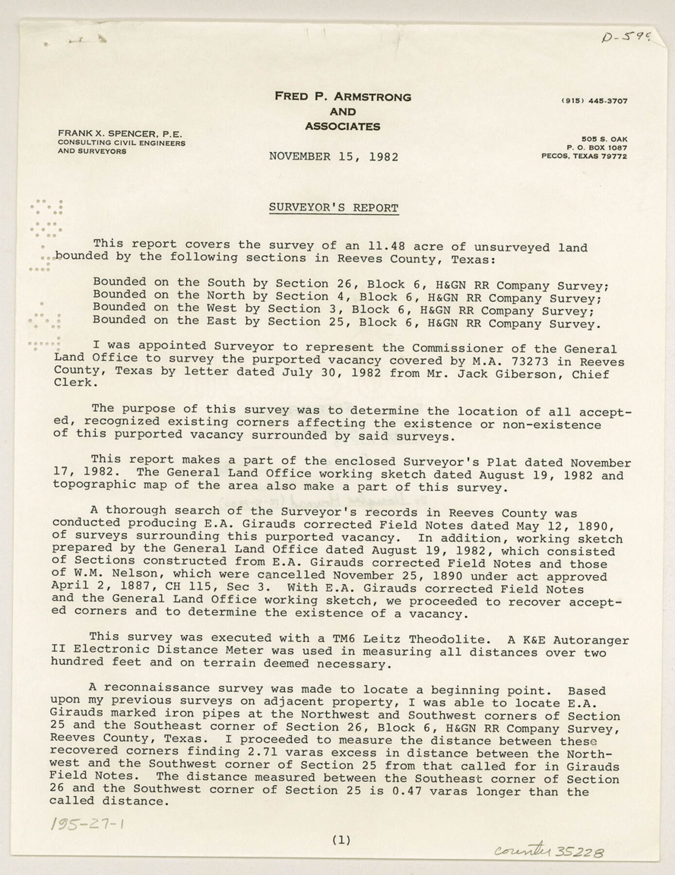
Reeves County Sketch File 27
[Report, field notes, and sketch regarding MA-73273 and adjoining surveys]
-
Map/Doc
35228
-
Collection
General Map Collection
-
Object Dates
1982/11/15 (Creation Date)
1982/12/4 (File Date)
-
People and Organizations
Frank X. Spencer (Surveyor/Engineer)
E.A. Giraud (Surveyor/Engineer)
W.M. Nelson (Surveyor/Engineer)
-
Counties
Reeves
-
Subjects
Surveying Sketch File
-
Height x Width
11.5 x 8.9 inches
29.2 x 22.6 cm
-
Medium
paper, print
-
Comments
See Reeves County Rolled Sketch 24 (7492) and Reeves County Rolled Sketch 24 (7493) for sketches.
-
Features
Pecos River
Roberson Ranch
Related maps
Reeves County Rolled Sketch 24

Print $20.00
- Digital $50.00
Reeves County Rolled Sketch 24
1982
Size 40.6 x 28.4 inches
Map/Doc 7492
Reeves County Rolled Sketch 24

Print $20.00
- Digital $50.00
Reeves County Rolled Sketch 24
1982
Size 37.2 x 24.9 inches
Map/Doc 7493
Part of: General Map Collection
McMullen County Working Sketch 34

Print $20.00
- Digital $50.00
McMullen County Working Sketch 34
1959
Size 25.9 x 26.0 inches
Map/Doc 70735
Starr County Working Sketch 3

Print $20.00
- Digital $50.00
Starr County Working Sketch 3
1920
Size 35.6 x 23.0 inches
Map/Doc 63919
Floyd County Sketch File 24

Print $6.00
- Digital $50.00
Floyd County Sketch File 24
1915
Size 9.0 x 14.5 inches
Map/Doc 22780
Jasper County Sketch File 32

Print $20.00
- Digital $50.00
Jasper County Sketch File 32
1906
Size 28.0 x 22.3 inches
Map/Doc 11853
Uvalde County Working Sketch 64

Print $20.00
- Digital $50.00
Uvalde County Working Sketch 64
1998
Size 29.9 x 30.6 inches
Map/Doc 72134
Ward County Working Sketch 55

Print $20.00
- Digital $50.00
Ward County Working Sketch 55
1986
Size 30.0 x 36.8 inches
Map/Doc 72361
Orange County Working Sketch 42

Print $20.00
- Digital $50.00
Orange County Working Sketch 42
1979
Size 19.6 x 25.4 inches
Map/Doc 71374
Lloyd's New Military Map of the Border & Southern States

Print $20.00
- Digital $50.00
Lloyd's New Military Map of the Border & Southern States
1864
Size 32.4 x 44.0 inches
Map/Doc 97517
Bowie County Sketch File 7

Print $40.00
- Digital $50.00
Bowie County Sketch File 7
1927
Size 18.0 x 35.5 inches
Map/Doc 10943
Map of Anderson County

Print $20.00
- Digital $50.00
Map of Anderson County
1895
Size 40.9 x 45.4 inches
Map/Doc 4784
Brewster County Rolled Sketch 61

Print $40.00
- Digital $50.00
Brewster County Rolled Sketch 61
1939
Size 43.7 x 70.3 inches
Map/Doc 8486
Palo Pinto County Rolled Sketch 12

Print $20.00
- Digital $50.00
Palo Pinto County Rolled Sketch 12
1984
Size 32.2 x 28.9 inches
Map/Doc 7192
You may also like
Ward County Rolled Sketch 24C

Print $40.00
- Digital $50.00
Ward County Rolled Sketch 24C
1967
Size 54.8 x 24.4 inches
Map/Doc 10114
General Highway Map, Caldwell County, Texas

Print $20.00
General Highway Map, Caldwell County, Texas
1961
Size 18.3 x 24.6 inches
Map/Doc 79394
Haskell County Sketch File 13

Print $37.00
- Digital $50.00
Haskell County Sketch File 13
Size 8.1 x 4.0 inches
Map/Doc 26142

Starr County Working Sketch 22

Print $20.00
- Digital $50.00
Starr County Working Sketch 22
1983
Size 25.8 x 33.1 inches
Map/Doc 63938
Map of Sherman County

Print $20.00
- Digital $50.00
Map of Sherman County
1902
Size 40.9 x 36.6 inches
Map/Doc 16815
Comanche County Working Sketch 21

Print $20.00
- Digital $50.00
Comanche County Working Sketch 21
1973
Size 28.0 x 26.1 inches
Map/Doc 68155
Dallam County Working Sketch 3

Print $20.00
- Digital $50.00
Dallam County Working Sketch 3
1960
Size 13.8 x 30.5 inches
Map/Doc 68588
Irion County Boundary File 1a

Print $40.00
- Digital $50.00
Irion County Boundary File 1a
Size 33.5 x 9.3 inches
Map/Doc 55325
Upton County Sketch File 45

Print $20.00
- Digital $50.00
Upton County Sketch File 45
1994
Size 11.3 x 8.8 inches
Map/Doc 38933
Fisher County Sketch File 19

Print $20.00
- Digital $50.00
Fisher County Sketch File 19
Size 18.8 x 15.7 inches
Map/Doc 11481
Hardin County Sketch File 66

Print $20.00
- Digital $50.00
Hardin County Sketch File 66
1948
Size 19.5 x 35.8 inches
Map/Doc 11639