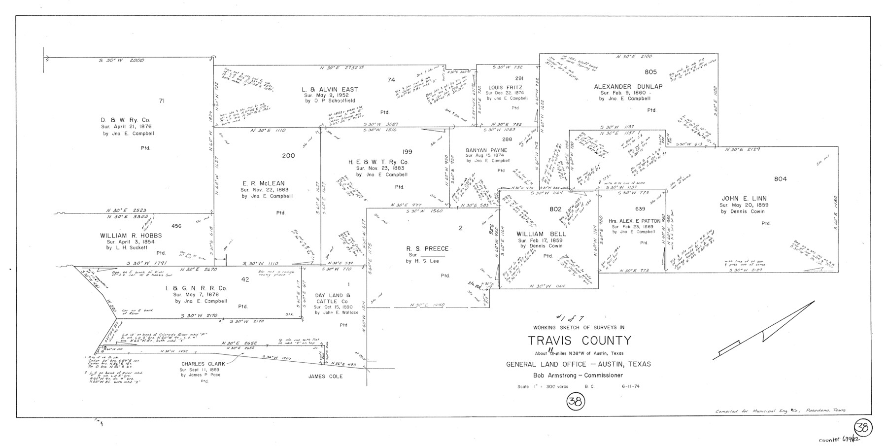
Travis County Working Sketch 38
-
Map/Doc
69422
-
Collection
General Map Collection
-
Object Dates
6/11/1974 (Creation Date)
-
People and Organizations
Beverly Christian (Draftsman)
-
Counties
Travis
-
Subjects
Surveying Working Sketch
-
Height x Width
17.5 x 34.8 inches
44.5 x 88.4 cm
-
Scale
1" = 300 varas
Part of: General Map Collection
Angelina County Working Sketch 55

Print $20.00
- Digital $50.00
Angelina County Working Sketch 55
1989
Size 33.7 x 30.0 inches
Map/Doc 67139
Concho County

Print $20.00
- Digital $50.00
Concho County
1897
Size 45.9 x 38.0 inches
Map/Doc 66785
Wilson County Sketch File 3

Print $6.00
- Digital $50.00
Wilson County Sketch File 3
1848
Size 13.3 x 8.6 inches
Map/Doc 40399
Yoakum County Sketch File 2

Print $6.00
- Digital $50.00
Yoakum County Sketch File 2
1892
Size 14.5 x 8.5 inches
Map/Doc 40702
Brewster County Working Sketch 103

Print $40.00
- Digital $50.00
Brewster County Working Sketch 103
1980
Size 48.4 x 31.1 inches
Map/Doc 67703
Webb County Sketch File 1-1

Print $4.00
- Digital $50.00
Webb County Sketch File 1-1
1857
Size 8.6 x 8.4 inches
Map/Doc 39708
Trinity County Working Sketch 22

Print $40.00
- Digital $50.00
Trinity County Working Sketch 22
2009
Size 32.0 x 52.1 inches
Map/Doc 89068
Kleberg County NRC Article 33.136 Location Key Sheet

Print $20.00
- Digital $50.00
Kleberg County NRC Article 33.136 Location Key Sheet
1975
Size 27.0 x 24.0 inches
Map/Doc 77051
Val Verde County Working Sketch 23

Print $20.00
- Digital $50.00
Val Verde County Working Sketch 23
1932
Size 29.6 x 24.9 inches
Map/Doc 72158

Map of Crockett Co.

Print $20.00
- Digital $50.00
Map of Crockett Co.
1894
Size 32.6 x 44.1 inches
Map/Doc 4725
Flight Mission No. DQN-2K, Frame 124, Calhoun County

Print $20.00
- Digital $50.00
Flight Mission No. DQN-2K, Frame 124, Calhoun County
1953
Size 18.5 x 22.2 inches
Map/Doc 84300
You may also like
Brewster County Rolled Sketch 57

Print $20.00
- Digital $50.00
Brewster County Rolled Sketch 57
1937
Size 43.1 x 37.8 inches
Map/Doc 8482
Rio Grande, Willamar Sheet

Print $20.00
- Digital $50.00
Rio Grande, Willamar Sheet
1937
Size 36.9 x 37.2 inches
Map/Doc 65111
Flight Mission No. CRC-2R, Frame 114, Chambers County

Print $20.00
- Digital $50.00
Flight Mission No. CRC-2R, Frame 114, Chambers County
1956
Size 18.5 x 22.4 inches
Map/Doc 84741
Map of the country adjacent to the left bank of the Rio Grande below Matamoros

Print $20.00
- Digital $50.00
Map of the country adjacent to the left bank of the Rio Grande below Matamoros
1847
Size 18.3 x 27.3 inches
Map/Doc 72868
Hardeman County Aerial Photograph Index Sheet 5

Print $20.00
- Digital $50.00
Hardeman County Aerial Photograph Index Sheet 5
1950
Size 19.0 x 16.9 inches
Map/Doc 83701
Upton County Sketch File 5

Print $40.00
- Digital $50.00
Upton County Sketch File 5
Size 8.7 x 24.4 inches
Map/Doc 38813
Walker County Working Sketch 6

Print $20.00
- Digital $50.00
Walker County Working Sketch 6
1935
Size 30.8 x 40.6 inches
Map/Doc 72286
Potter County Rolled Sketch 11

Print $20.00
- Digital $50.00
Potter County Rolled Sketch 11
1986
Size 21.6 x 27.4 inches
Map/Doc 7324
Railroad Track Map, H&TCRRCo., Falls County, Texas

Print $4.00
- Digital $50.00
Railroad Track Map, H&TCRRCo., Falls County, Texas
1918
Size 11.8 x 18.4 inches
Map/Doc 62838
Limestone County

Print $40.00
- Digital $50.00
Limestone County
1922
Size 50.6 x 36.2 inches
Map/Doc 73342
Castro County

Print $20.00
- Digital $50.00
Castro County
1932
Size 39.2 x 34.4 inches
Map/Doc 77234
Frio County Working Sketch 28

Print $20.00
- Digital $50.00
Frio County Working Sketch 28
2006
Size 40.8 x 42.0 inches
Map/Doc 83605