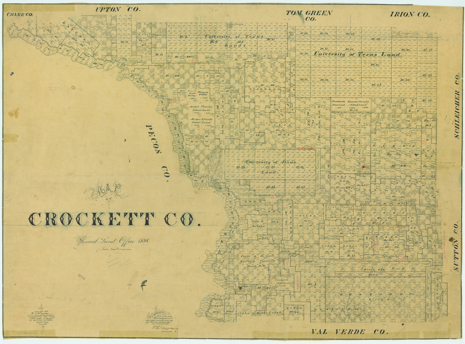
Map of Crockett Co.
-
Map/Doc
4725
-
Collection
General Map Collection
-
Object Dates
1894 (Creation Date)
-
People and Organizations
Texas General Land Office (Publisher)
W.L. McGaughey (GLO Commissioner)
-
Counties
Crockett
-
Subjects
County
-
Height x Width
32.6 x 44.1 inches
82.8 x 112.0 cm
-
Comments
Copyrighted 1894.
Help Save Texas History - Adopt Me! -
Features
Howards Well
Grierson Spring
Pontoon Bridge
Johnson's Run Creek
Fort Lancaster
Pecos River
Ozona
Taylor's Creek
Howard's Creek
Devils River
Part of: General Map Collection
Flight Mission No. CGI-4N, Frame 182, Cameron County

Print $20.00
- Digital $50.00
Flight Mission No. CGI-4N, Frame 182, Cameron County
1955
Size 18.4 x 22.2 inches
Map/Doc 84685
Ellis County Boundary File 2

Print $12.00
- Digital $50.00
Ellis County Boundary File 2
Size 10.7 x 8.3 inches
Map/Doc 52944
Flight Mission No. CRC-4R, Frame 79, Chambers County

Print $20.00
- Digital $50.00
Flight Mission No. CRC-4R, Frame 79, Chambers County
1956
Size 18.9 x 22.6 inches
Map/Doc 84883
Montgomery County Working Sketch 33

Print $20.00
- Digital $50.00
Montgomery County Working Sketch 33
1950
Size 28.8 x 28.2 inches
Map/Doc 71140
Val Verde County Sketch File XXX10

Print $20.00
- Digital $50.00
Val Verde County Sketch File XXX10
Size 25.9 x 19.2 inches
Map/Doc 12549
Calhoun County Rolled Sketch 29B

Print $20.00
- Digital $50.00
Calhoun County Rolled Sketch 29B
Size 43.4 x 45.0 inches
Map/Doc 8558
Galveston County Rolled Sketch 27

Print $20.00
- Digital $50.00
Galveston County Rolled Sketch 27
1978
Size 29.6 x 33.3 inches
Map/Doc 10301
Motley County Sketch File 19 (N)

Print $24.00
- Digital $50.00
Motley County Sketch File 19 (N)
1940
Size 14.2 x 8.8 inches
Map/Doc 32064
Pecos County Boundary File 1

Print $2.00
- Digital $50.00
Pecos County Boundary File 1
Size 10.1 x 8.0 inches
Map/Doc 57854
Crockett County Sketch File 29

Print $8.00
- Digital $50.00
Crockett County Sketch File 29
1883
Size 12.5 x 8.1 inches
Map/Doc 19727
Reagan County Rolled Sketch 32

Print $20.00
- Digital $50.00
Reagan County Rolled Sketch 32
Size 46.3 x 38.5 inches
Map/Doc 9827
Coast Chart No. 212 - From Latitude 26° 33' to the Rio Grande Texas

Print $20.00
- Digital $50.00
Coast Chart No. 212 - From Latitude 26° 33' to the Rio Grande Texas
1886
Size 18.3 x 24.3 inches
Map/Doc 72836
You may also like
Burnet County Working Sketch 25

Print $20.00
- Digital $50.00
Burnet County Working Sketch 25
2000
Size 24.2 x 30.3 inches
Map/Doc 67868
Newton County Working Sketch 40

Print $20.00
- Digital $50.00
Newton County Working Sketch 40
1970
Size 43.6 x 39.7 inches
Map/Doc 71286
Starr County Working Sketch 27

Print $20.00
- Digital $50.00
Starr County Working Sketch 27
1994
Size 29.6 x 30.3 inches
Map/Doc 63943
Brooks County Rolled Sketch 11

Print $20.00
- Digital $50.00
Brooks County Rolled Sketch 11
1906
Size 29.0 x 28.4 inches
Map/Doc 5337
Wise County Sketch File 19

Print $4.00
- Digital $50.00
Wise County Sketch File 19
1857
Size 11.0 x 8.2 inches
Map/Doc 40555
Jim Wells Co.

Print $20.00
- Digital $50.00
Jim Wells Co.
1966
Size 40.3 x 28.9 inches
Map/Doc 77331
San Patricio County Rolled Sketch 45

Print $20.00
- Digital $50.00
San Patricio County Rolled Sketch 45
1979
Size 24.0 x 33.5 inches
Map/Doc 7729
Flight Mission No. BRE-2P, Frame 19, Nueces County

Print $20.00
- Digital $50.00
Flight Mission No. BRE-2P, Frame 19, Nueces County
1956
Size 18.4 x 22.2 inches
Map/Doc 86728
Tech Memorial Park Street Grading Plan

Print $20.00
- Digital $50.00
Tech Memorial Park Street Grading Plan
1948
Size 17.8 x 15.7 inches
Map/Doc 92272
Edwards County Working Sketch 49

Print $20.00
- Digital $50.00
Edwards County Working Sketch 49
1950
Size 23.6 x 28.1 inches
Map/Doc 68925
Burnet County Sketch File 46

Print $4.00
- Digital $50.00
Burnet County Sketch File 46
1873
Size 12.8 x 8.5 inches
Map/Doc 16773
Nueces County Rolled Sketch 78

Print $53.00
Nueces County Rolled Sketch 78
1982
Size 18.2 x 24.9 inches
Map/Doc 6945