Brooks County Rolled Sketch 11
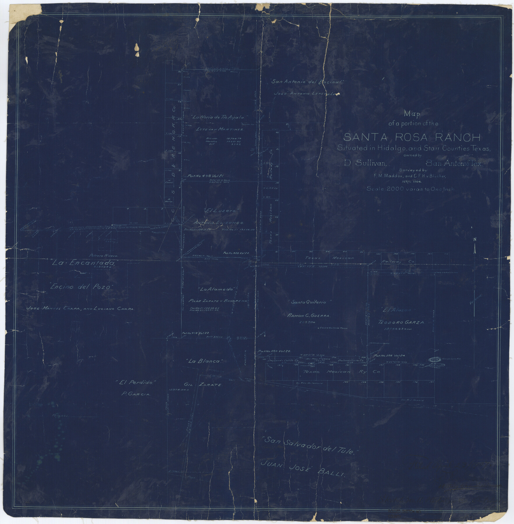
Map of a portion of the Santa Rosa Ranch situated in Hidalgo and Starr Counties, Texas
-
Map/Doc
5337
-
Collection
General Map Collection
-
Object Dates
1906 (Creation Date)
1907/4/23 (File Date)
-
People and Organizations
C.F.H. von Blucher (Surveyor/Engineer)
F.M. Maddox (Surveyor/Engineer)
D. Sullivan (Landowner)
-
Counties
Brooks
-
Subjects
Surveying Rolled Sketch
-
Height x Width
29.0 x 28.4 inches
73.7 x 72.1 cm
-
Medium
blueprint/diazo
-
Scale
1" = 2000 varas
Part of: General Map Collection
San Augustine County Working Sketch 7

Print $20.00
- Digital $50.00
San Augustine County Working Sketch 7
1935
Size 24.7 x 34.8 inches
Map/Doc 63694
Crane County Rolled Sketch 22

Print $20.00
- Digital $50.00
Crane County Rolled Sketch 22
1990
Size 12.5 x 19.3 inches
Map/Doc 5578
Galveston County NRC Article 33.136 Sketch 72

Print $78.00
- Digital $50.00
Galveston County NRC Article 33.136 Sketch 72
2013
Size 24.0 x 36.0 inches
Map/Doc 95081
Flight Mission No. DQN-3K, Frame 7, Calhoun County

Print $20.00
- Digital $50.00
Flight Mission No. DQN-3K, Frame 7, Calhoun County
1953
Size 18.6 x 22.2 inches
Map/Doc 84339
La Salle County Sketch File 19

Print $32.00
- Digital $50.00
La Salle County Sketch File 19
1885
Size 14.2 x 8.7 inches
Map/Doc 29509
Falls County Working Sketch 4

Print $20.00
- Digital $50.00
Falls County Working Sketch 4
1943
Size 24.3 x 22.0 inches
Map/Doc 69179
Kendall County Sketch File 16

Print $4.00
- Digital $50.00
Kendall County Sketch File 16
1877
Size 8.7 x 5.9 inches
Map/Doc 28705
G. C. & S. F. Ry., San Saba Branch, Texas, Right of Way Map, Hall to Brady

Print $40.00
- Digital $50.00
G. C. & S. F. Ry., San Saba Branch, Texas, Right of Way Map, Hall to Brady
1916
Size 38.9 x 124.3 inches
Map/Doc 61418
Burnet County Sketch File 10

Print $4.00
- Digital $50.00
Burnet County Sketch File 10
1848
Size 12.8 x 8.4 inches
Map/Doc 16690
Gillespie County Sketch File 9

Print $4.00
- Digital $50.00
Gillespie County Sketch File 9
1873
Size 8.2 x 10.5 inches
Map/Doc 24145
[Map of Zapata County]
![4178, [Map of Zapata County], General Map Collection](https://historictexasmaps.com/wmedia_w700/maps/4178.tif.jpg)
Print $20.00
- Digital $50.00
[Map of Zapata County]
1883
Size 20.5 x 20.9 inches
Map/Doc 4178
Nueces County

Print $20.00
- Digital $50.00
Nueces County
1913
Size 26.4 x 34.1 inches
Map/Doc 66957
You may also like
Houston County Sketch File 3

Print $6.00
- Digital $50.00
Houston County Sketch File 3
Size 13.1 x 8.2 inches
Map/Doc 26748
Waller County

Print $20.00
- Digital $50.00
Waller County
1897
Size 46.0 x 30.2 inches
Map/Doc 63107
Llano County Working Sketch 3

Print $20.00
- Digital $50.00
Llano County Working Sketch 3
1949
Size 23.6 x 24.0 inches
Map/Doc 70621
Reagan County Rolled Sketch 12

Print $20.00
- Digital $50.00
Reagan County Rolled Sketch 12
1940
Size 25.9 x 27.0 inches
Map/Doc 7440

Brown County Sketch File 27

Print $4.00
- Digital $50.00
Brown County Sketch File 27
1868
Size 13.3 x 8.1 inches
Map/Doc 16624

Harrison County Sketch File 15

Print $20.00
- Digital $50.00
Harrison County Sketch File 15
Size 23.2 x 23.0 inches
Map/Doc 11690
The Mexican Municipality of Brazoria. December 28, 1834

Print $20.00
The Mexican Municipality of Brazoria. December 28, 1834
2020
Size 16.5 x 21.7 inches
Map/Doc 96017
Coleman County Sketch File 33

Print $2.00
- Digital $50.00
Coleman County Sketch File 33
Size 8.4 x 7.0 inches
Map/Doc 18725
Jefferson County Working Sketch 28

Print $20.00
- Digital $50.00
Jefferson County Working Sketch 28
1977
Size 46.2 x 42.9 inches
Map/Doc 66571
Map of Texas and Pacific Ry. Company's Surveys in the 80 Mile Reserve

Print $40.00
- Digital $50.00
Map of Texas and Pacific Ry. Company's Surveys in the 80 Mile Reserve
1885
Size 44.0 x 51.6 inches
Map/Doc 83557