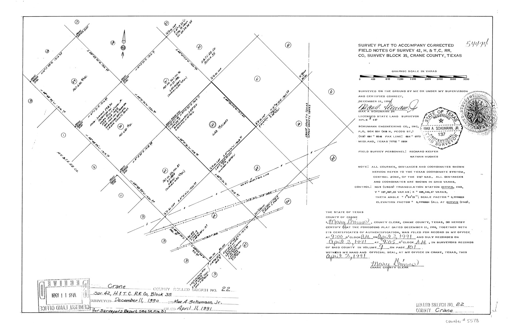
Crane County Rolled Sketch 22
Survey plat to accompany corrected field notes of survey 42, H. & T. C. RR. Co. survey Block 35, Crane County, Texas
-
Map/Doc
5578
-
Collection
General Map Collection
-
Object Dates
1990/12/11 (Creation Date)
1991/4/11 (File Date)
-
People and Organizations
Max A. Schumann, Jr. (Surveyor/Engineer)
Richard Keifer (Chainman/Field Personnel)
Nathan Hughes (Chainman/Field Personnel)
-
Counties
Crane
-
Subjects
Surveying Rolled Sketch
-
Height x Width
12.5 x 19.3 inches
31.8 x 49.0 cm
-
Medium
mylar, print
-
Comments
See Crane County Sketch File 31 (19620) for surveyor’s report.
Related maps
Crane County Sketch File 31

Print $8.00
- Digital $50.00
Crane County Sketch File 31
1991
Size 11.3 x 8.9 inches
Map/Doc 19620
Part of: General Map Collection
Travis County Sketch File 28

Print $40.00
- Digital $50.00
Travis County Sketch File 28
Size 17.5 x 12.2 inches
Map/Doc 38341
Galveston County Working Sketch 1

Print $20.00
- Digital $50.00
Galveston County Working Sketch 1
Size 27.7 x 33.7 inches
Map/Doc 69338
Flight Mission No. DAG-23K, Frame 149, Matagorda County

Print $20.00
- Digital $50.00
Flight Mission No. DAG-23K, Frame 149, Matagorda County
1953
Size 15.9 x 15.9 inches
Map/Doc 86497
[Valdez and Martinez grants in the Goliad District]
![54, [Valdez and Martinez grants in the Goliad District], General Map Collection](https://historictexasmaps.com/wmedia_w700/maps/54.tif.jpg)
Print $3.00
- Digital $50.00
[Valdez and Martinez grants in the Goliad District]
1842
Size 10.6 x 9.5 inches
Map/Doc 54
Southern Part of Laguna Madre

Print $20.00
- Digital $50.00
Southern Part of Laguna Madre
1981
Size 45.1 x 35.8 inches
Map/Doc 73546
Angelina County Sketch File 29

Print $4.00
- Digital $50.00
Angelina County Sketch File 29
1911
Size 8.0 x 8.4 inches
Map/Doc 13087
Dallas County Boundary File 1

Print $62.00
- Digital $50.00
Dallas County Boundary File 1
Size 4.1 x 3.7 inches
Map/Doc 52084
Angelina River, Mud Creek, Sheet 1

Print $4.00
- Digital $50.00
Angelina River, Mud Creek, Sheet 1
1937
Size 26.2 x 18.5 inches
Map/Doc 65075
Reagan County Working Sketch 46b

Print $20.00
- Digital $50.00
Reagan County Working Sketch 46b
1987
Size 31.4 x 45.2 inches
Map/Doc 71889
Flight Mission No. BRA-7M, Frame 200, Jefferson County

Print $20.00
- Digital $50.00
Flight Mission No. BRA-7M, Frame 200, Jefferson County
1953
Size 18.8 x 22.4 inches
Map/Doc 85568
Sterling County Sketch File 8

Print $20.00
- Digital $50.00
Sterling County Sketch File 8
1916
Size 27.2 x 25.2 inches
Map/Doc 12357
McCulloch County Sketch File 4

Print $4.00
- Digital $50.00
McCulloch County Sketch File 4
1883
Size 11.1 x 8.5 inches
Map/Doc 31175
You may also like
Maps of Gulf Intracoastal Waterway, Texas - Sabine River to the Rio Grande and connecting waterways including ship channels

Print $20.00
- Digital $50.00
Maps of Gulf Intracoastal Waterway, Texas - Sabine River to the Rio Grande and connecting waterways including ship channels
1966
Size 14.6 x 21.7 inches
Map/Doc 61981

Ater Heights Section 44, Block AK

Print $20.00
- Digital $50.00
Ater Heights Section 44, Block AK
1952
Size 11.9 x 18.9 inches
Map/Doc 92347
Atascosa County Sketch File 29

Print $40.00
- Digital $50.00
Atascosa County Sketch File 29
Size 23.7 x 12.9 inches
Map/Doc 10863
Upton County Working Sketch 34

Print $40.00
- Digital $50.00
Upton County Working Sketch 34
1956
Size 29.6 x 49.1 inches
Map/Doc 69530
Colorado County Sketch File 32

Print $4.00
- Digital $50.00
Colorado County Sketch File 32
1847
Size 13.0 x 8.4 inches
Map/Doc 18986

Hutchinson County Rolled Sketch 10

Print $20.00
- Digital $50.00
Hutchinson County Rolled Sketch 10
Size 33.6 x 29.7 inches
Map/Doc 6281
Hall County Sketch File 6

Print $20.00
- Digital $50.00
Hall County Sketch File 6
1885
Size 28.2 x 37.9 inches
Map/Doc 10473
[Map of Polk County]
![4613, [Map of Polk County], General Map Collection](https://historictexasmaps.com/wmedia_w700/maps/4613-1.tif.jpg)
Print $20.00
- Digital $50.00
[Map of Polk County]
1855
Size 21.2 x 31.0 inches
Map/Doc 4613
Presidio County Sketch File 45

Print $6.00
- Digital $50.00
Presidio County Sketch File 45
1914
Size 11.3 x 8.8 inches
Map/Doc 34532
Houston County Working Sketch 29

Print $20.00
- Digital $50.00
Houston County Working Sketch 29
1990
Size 23.4 x 23.1 inches
Map/Doc 66259