Harrison County Sketch File 15
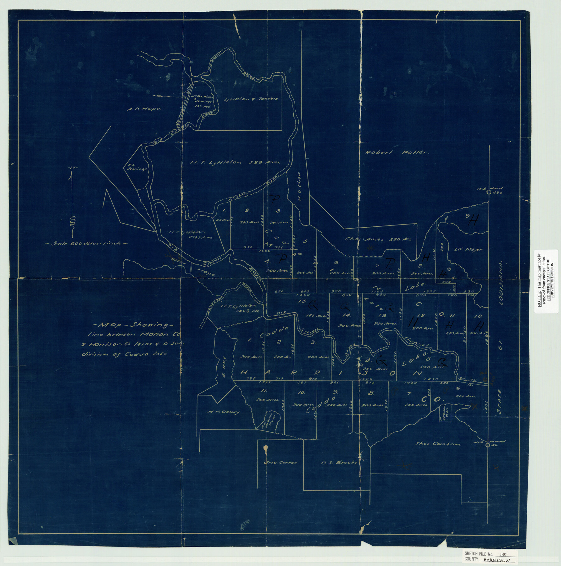
Map showing line between Marion Co. & Harrison Co. Texas & O Subdivision of Caddo Lake
-
Map/Doc
11690
-
Collection
General Map Collection
-
Counties
Harrison Marion
-
Subjects
Surveying Sketch File
-
Height x Width
23.2 x 23.0 inches
58.9 x 58.4 cm
-
Medium
blueprint/diazo
-
Scale
1:600
-
Features
Alligator Bayou
Big Cypress Bayou
Government Ditch
Harralson Bayou
Caddo Lake
Part of: General Map Collection
Montgomery County Sketch File 18

Print $20.00
- Digital $50.00
Montgomery County Sketch File 18
1899
Size 22.1 x 19.6 inches
Map/Doc 42122
Uvalde County Sketch File 14

Print $6.00
- Digital $50.00
Uvalde County Sketch File 14
1849
Size 8.5 x 11.0 inches
Map/Doc 12529
Marion County Rolled Sketch 9A

Print $20.00
- Digital $50.00
Marion County Rolled Sketch 9A
2001
Size 22.9 x 22.9 inches
Map/Doc 76419
Sutton County Rolled Sketch 67

Print $20.00
- Digital $50.00
Sutton County Rolled Sketch 67
Size 25.4 x 37.3 inches
Map/Doc 7902
Victoria County Rolled Sketch 8

Print $20.00
- Digital $50.00
Victoria County Rolled Sketch 8
Size 34.2 x 27.5 inches
Map/Doc 8153
Maps & Lists Showing Prison Lands (Oil & Gas) Leased as of June 1955

Digital $50.00
Maps & Lists Showing Prison Lands (Oil & Gas) Leased as of June 1955
1934
Size 19.1 x 38.7 inches
Map/Doc 62878
Williamson County Working Sketch 14

Print $20.00
- Digital $50.00
Williamson County Working Sketch 14
1982
Size 22.0 x 28.3 inches
Map/Doc 72574
Fannin County Working Sketch 9

Print $20.00
- Digital $50.00
Fannin County Working Sketch 9
1973
Size 28.1 x 21.9 inches
Map/Doc 69163
J. De Cordova's Map of the State of Texas Compiled from the records of the General Land Office of the State

Print $20.00
- Digital $50.00
J. De Cordova's Map of the State of Texas Compiled from the records of the General Land Office of the State
1858
Size 31.6 x 29.6 inches
Map/Doc 2127
Jackson County Sketch File 24

Print $20.00
- Digital $50.00
Jackson County Sketch File 24
1949
Size 17.5 x 23.4 inches
Map/Doc 11844
Calhoun County NRC Article 33.136 Sketch 3

Print $40.00
- Digital $50.00
Calhoun County NRC Article 33.136 Sketch 3
2000
Size 24.4 x 36.5 inches
Map/Doc 81914
Brazoria County Sketch File 57

Print $10.00
- Digital $50.00
Brazoria County Sketch File 57
1940
Size 8.7 x 6.3 inches
Map/Doc 15377
You may also like
Flight Mission No. CGI-1N, Frame 222, Cameron County

Print $20.00
- Digital $50.00
Flight Mission No. CGI-1N, Frame 222, Cameron County
1955
Size 18.4 x 22.1 inches
Map/Doc 84532
Reagan County Rolled Sketch 16

Print $20.00
- Digital $50.00
Reagan County Rolled Sketch 16
Size 25.6 x 47.5 inches
Map/Doc 9811
Val Verde County Working Sketch 9

Print $20.00
- Digital $50.00
Val Verde County Working Sketch 9
1917
Size 19.4 x 30.9 inches
Map/Doc 72144
St. Louis, Brownsville & Mexico

Print $40.00
- Digital $50.00
St. Louis, Brownsville & Mexico
1906
Size 20.0 x 127.8 inches
Map/Doc 89281

Flight Mission No. BRA-16M, Frame 72, Jefferson County

Print $20.00
- Digital $50.00
Flight Mission No. BRA-16M, Frame 72, Jefferson County
1953
Size 18.5 x 22.4 inches
Map/Doc 85689
Map of Wise County

Print $20.00
- Digital $50.00
Map of Wise County
1895
Size 41.8 x 37.2 inches
Map/Doc 16932
[Cotton Belt, St. Louis Southwestern Railway of Texas, Alignment through Smith County]
![64386, [Cotton Belt, St. Louis Southwestern Railway of Texas, Alignment through Smith County], General Map Collection](https://historictexasmaps.com/wmedia_w700/maps/64386.tif.jpg)
Print $20.00
- Digital $50.00
[Cotton Belt, St. Louis Southwestern Railway of Texas, Alignment through Smith County]
1903
Size 21.7 x 29.3 inches
Map/Doc 64386
Hall County Boundary File 1

Print $26.00
- Digital $50.00
Hall County Boundary File 1
Size 8.8 x 4.0 inches
Map/Doc 54158
Flight Mission No. CUG-3P, Frame 39, Kleberg County

Print $20.00
- Digital $50.00
Flight Mission No. CUG-3P, Frame 39, Kleberg County
1956
Size 18.4 x 22.2 inches
Map/Doc 86244
University of Texas Land Survey Isogonic Chart and Graph of Meridian Changes on University Lands Principally in Andrews County, Texas

Print $20.00
- Digital $50.00
University of Texas Land Survey Isogonic Chart and Graph of Meridian Changes on University Lands Principally in Andrews County, Texas
Size 15.0 x 18.4 inches
Map/Doc 62947
Harris County NRC Article 33.136 Location Key Sheet

Print $20.00
- Digital $50.00
Harris County NRC Article 33.136 Location Key Sheet
1982
Size 27.0 x 22.5 inches
Map/Doc 77026