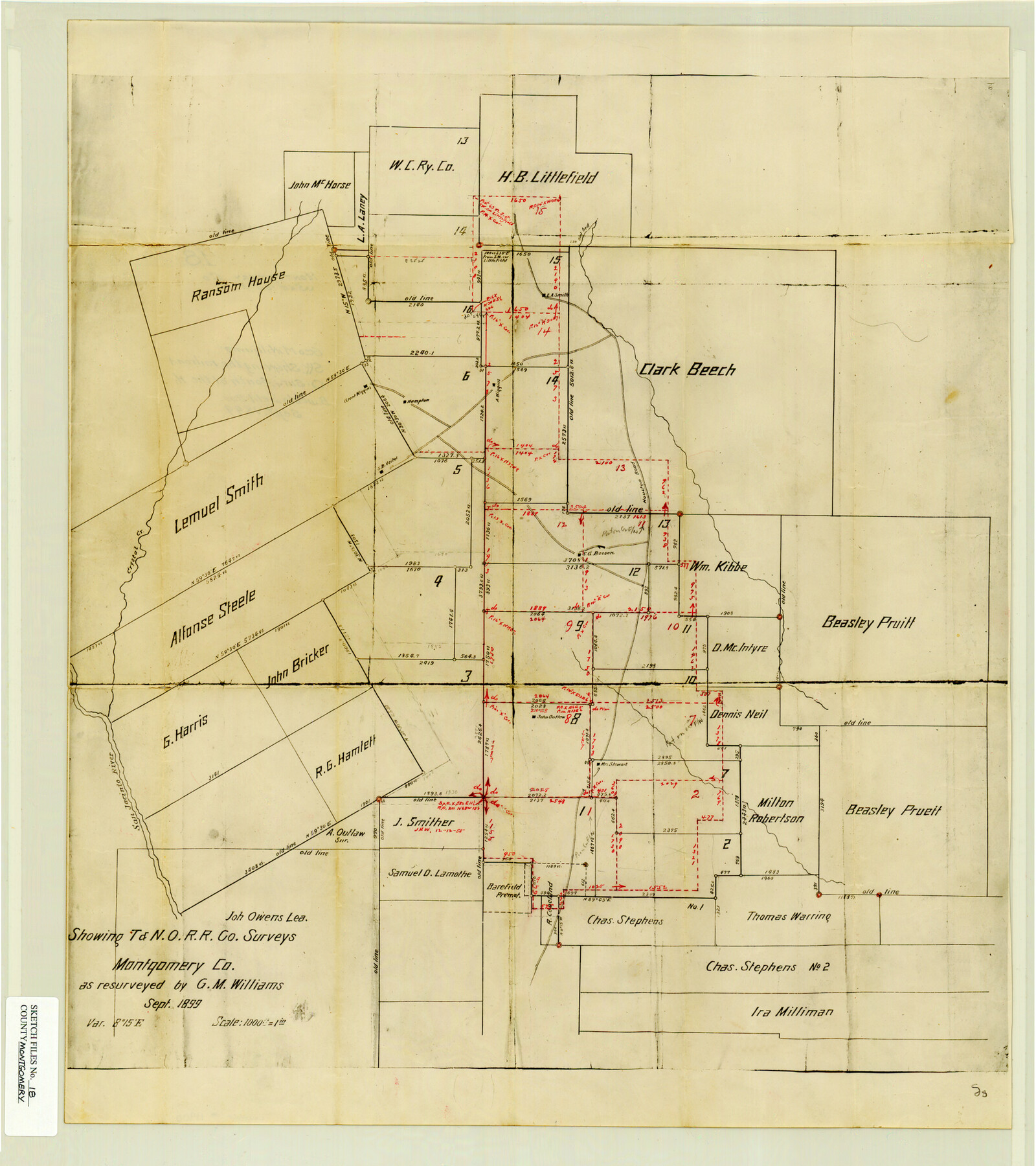
Montgomery County Sketch File 18
[Sketch] Showing T. & N.O. R.R. Co. Surveys, Montgomery Co.
-
Map/Doc
42122
-
Collection
General Map Collection
-
Object Dates
9/1899 (Creation Date)
-
People and Organizations
G.M. Williams (Surveyor/Engineer)
-
Counties
Montgomery
-
Subjects
Surveying Sketch File
-
Height x Width
22.1 x 19.6 inches
56.1 x 49.8 cm
-
Medium
paper, manuscript
-
Scale
1" = 1000 varas
-
Features
Crystal Creek
S.G. Beeson
Grant Wiggins
S.B. Veitel
Hampton
John Outlaw
San Jacinto River
Part of: General Map Collection
Travis County Working Sketch 63

Print $20.00
- Digital $50.00
Travis County Working Sketch 63
1998
Size 24.0 x 29.5 inches
Map/Doc 69447
Pecos County Rolled Sketch 87

Print $20.00
- Digital $50.00
Pecos County Rolled Sketch 87
1933
Size 37.7 x 27.2 inches
Map/Doc 7244
Map of Eagle Lake

Print $20.00
- Digital $50.00
Map of Eagle Lake
1938
Size 13.0 x 17.0 inches
Map/Doc 2208
Val Verde County Sketch File Z12

Print $4.00
- Digital $50.00
Val Verde County Sketch File Z12
1898
Size 11.4 x 8.8 inches
Map/Doc 39140
[Sketch for Mineral Application 33721 - 33725 Incl. - Padre and Mustang Island]
![2868, [Sketch for Mineral Application 33721 - 33725 Incl. - Padre and Mustang Island], General Map Collection](https://historictexasmaps.com/wmedia_w700/maps/2868.tif.jpg)
Print $20.00
- Digital $50.00
[Sketch for Mineral Application 33721 - 33725 Incl. - Padre and Mustang Island]
1942
Size 29.7 x 22.3 inches
Map/Doc 2868
Brooks County Working Sketch 3

Print $20.00
- Digital $50.00
Brooks County Working Sketch 3
Size 16.2 x 21.3 inches
Map/Doc 67787
Lampasas County Boundary File 3

Print $10.00
- Digital $50.00
Lampasas County Boundary File 3
Size 8.4 x 7.3 inches
Map/Doc 56101

Intracoastal Waterway - Galveston Bay to West Bay including Galveston Bay Entrance

Print $20.00
- Digital $50.00
Intracoastal Waterway - Galveston Bay to West Bay including Galveston Bay Entrance
1962
Size 26.8 x 38.4 inches
Map/Doc 69937
Duval County Sketch File 69

Print $20.00
- Digital $50.00
Duval County Sketch File 69
1951
Size 30.2 x 13.3 inches
Map/Doc 11408

Victoria County Rolled Sketch 4C

Print $40.00
- Digital $50.00
Victoria County Rolled Sketch 4C
1963
Size 65.0 x 43.3 inches
Map/Doc 10097
You may also like
Parker County Sketch File 45

Print $10.00
- Digital $50.00
Parker County Sketch File 45
1935
Size 11.0 x 8.5 inches
Map/Doc 33610
Cherokee County Working Sketch 22

Print $20.00
- Digital $50.00
Cherokee County Working Sketch 22
1972
Size 24.0 x 19.2 inches
Map/Doc 67977
Andrews County Working Sketch 17

Print $20.00
- Digital $50.00
Andrews County Working Sketch 17
1963
Size 30.7 x 27.1 inches
Map/Doc 67063
Comanche County Working Sketch 20

Print $20.00
- Digital $50.00
Comanche County Working Sketch 20
1973
Size 20.5 x 15.6 inches
Map/Doc 68154
Plat in Pecos County, Texas

Print $20.00
- Digital $50.00
Plat in Pecos County, Texas
Size 21.4 x 14.9 inches
Map/Doc 91673
[Sketch Showing Surveys in Schleicher, Menard & Concho Counties, Texas]
![75782, [Sketch Showing Surveys in Schleicher, Menard & Concho Counties, Texas], Maddox Collection](https://historictexasmaps.com/wmedia_w700/maps/75782.tif.jpg)
Print $20.00
- Digital $50.00
[Sketch Showing Surveys in Schleicher, Menard & Concho Counties, Texas]
Size 16.1 x 28.9 inches
Map/Doc 75782
Flight Mission No. BRE-2P, Frame 102, Nueces County

Print $20.00
- Digital $50.00
Flight Mission No. BRE-2P, Frame 102, Nueces County
1956
Size 18.4 x 22.2 inches
Map/Doc 86787
Coast Chart No. 210 Aransas Pass and Corpus Christi Bay with the coast to latitude 27° 12' Texas

Print $20.00
- Digital $50.00
Coast Chart No. 210 Aransas Pass and Corpus Christi Bay with the coast to latitude 27° 12' Texas
1887
Size 27.5 x 18.4 inches
Map/Doc 72786
Outer Continental Shelf Leasing Maps (Louisiana Offshore Operations)

Print $20.00
- Digital $50.00
Outer Continental Shelf Leasing Maps (Louisiana Offshore Operations)
1959
Size 13.7 x 17.4 inches
Map/Doc 76116
Official Highway Map of the State of Vermont

Print $20.00
- Digital $50.00
Official Highway Map of the State of Vermont
1923
Size 44.8 x 28.6 inches
Map/Doc 97112
Kerr County State Real Property Sketch 1

Print $20.00
- Digital $50.00
Kerr County State Real Property Sketch 1
2007
Size 24.9 x 35.1 inches
Map/Doc 88669
Dickens County Working Sketch 5b

Print $40.00
- Digital $50.00
Dickens County Working Sketch 5b
1917
Size 59.4 x 43.3 inches
Map/Doc 68653