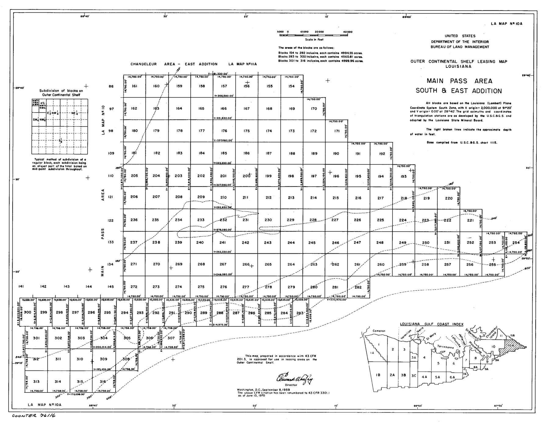
Outer Continental Shelf Leasing Maps (Louisiana Offshore Operations)
D-7-3; D-7-4
-
Map/Doc
76116
-
Collection
General Map Collection
-
Object Dates
1959/9/8 (Creation Date)
-
Subjects
Energy Offshore Submerged Area
-
Height x Width
13.7 x 17.4 inches
34.8 x 44.2 cm
Part of: General Map Collection
Kinney County Sketch File 25

Print $20.00
- Digital $50.00
Kinney County Sketch File 25
1927
Size 19.1 x 18.9 inches
Map/Doc 11944
Henderson County Working Sketch 44

Print $20.00
- Digital $50.00
Henderson County Working Sketch 44
1998
Size 19.0 x 33.0 inches
Map/Doc 66177
Calhoun County

Print $20.00
- Digital $50.00
Calhoun County
1883
Size 22.9 x 19.1 inches
Map/Doc 66741
Milam County Sketch File 8

Print $20.00
- Digital $50.00
Milam County Sketch File 8
1856
Size 16.8 x 33.7 inches
Map/Doc 12091
Flight Mission No. CRC-3R, Frame 43, Chambers County

Print $20.00
- Digital $50.00
Flight Mission No. CRC-3R, Frame 43, Chambers County
1956
Size 18.5 x 22.3 inches
Map/Doc 84816
Orange County Working Sketch 38

Print $20.00
- Digital $50.00
Orange County Working Sketch 38
1964
Size 25.4 x 27.7 inches
Map/Doc 71370

Presidio County Rolled Sketch 131A

Print $20.00
- Digital $50.00
Presidio County Rolled Sketch 131A
1992
Size 36.0 x 45.5 inches
Map/Doc 9801
Flight Mission No. CRC-4R, Frame 178, Chambers County

Print $20.00
- Digital $50.00
Flight Mission No. CRC-4R, Frame 178, Chambers County
1956
Size 18.5 x 22.2 inches
Map/Doc 84929
Map of Panola County

Print $20.00
- Digital $50.00
Map of Panola County
1897
Size 39.5 x 39.1 inches
Map/Doc 66967
Marion County Rolled Sketch JRC

Print $20.00
- Digital $50.00
Marion County Rolled Sketch JRC
1953
Size 19.4 x 20.5 inches
Map/Doc 6662
Gaines County Sketch File 25

Print $4.00
- Digital $50.00
Gaines County Sketch File 25
2002
Size 11.0 x 8.5 inches
Map/Doc 82618
You may also like
Clay County Sketch File 38a

Print $6.00
- Digital $50.00
Clay County Sketch File 38a
1939
Size 14.3 x 8.8 inches
Map/Doc 18469
Flight Mission No. DAG-24K, Frame 157, Matagorda County

Print $20.00
- Digital $50.00
Flight Mission No. DAG-24K, Frame 157, Matagorda County
1953
Size 18.6 x 22.5 inches
Map/Doc 86571
A Part of Blocks 31 and 32 Township 5 North

Print $20.00
- Digital $50.00
A Part of Blocks 31 and 32 Township 5 North
Size 19.6 x 23.8 inches
Map/Doc 92458
Houston County Sketch File 19

Print $4.00
- Digital $50.00
Houston County Sketch File 19
1851
Size 12.8 x 8.3 inches
Map/Doc 26785
Brewster County Sketch File NS-4e

Print $26.00
- Digital $50.00
Brewster County Sketch File NS-4e
1930
Size 8.7 x 11.2 inches
Map/Doc 15965
J. B. McCauley Irrigated Farm SW Quarter Section 20, Block E

Print $20.00
- Digital $50.00
J. B. McCauley Irrigated Farm SW Quarter Section 20, Block E
1944
Size 20.7 x 23.5 inches
Map/Doc 92335
Shackelford County Boundary File 6

Print $6.00
- Digital $50.00
Shackelford County Boundary File 6
Size 11.4 x 8.8 inches
Map/Doc 58668
Burnet County Sketch File 42

Print $28.00
- Digital $50.00
Burnet County Sketch File 42
1950
Size 9.9 x 8.8 inches
Map/Doc 16760
Revised Map of Calvert, Robertson County, Texas

Print $20.00
- Digital $50.00
Revised Map of Calvert, Robertson County, Texas
Size 25.4 x 19.4 inches
Map/Doc 88741
Presidio County Working Sketch 145

Print $20.00
- Digital $50.00
Presidio County Working Sketch 145
1990
Size 29.5 x 42.7 inches
Map/Doc 71823
Liberty County Boundary File 2

Print $9.00
- Digital $50.00
Liberty County Boundary File 2
Size 17.0 x 11.0 inches
Map/Doc 56293
Jim Hogg County Working Sketch Graphic Index

Print $20.00
- Digital $50.00
Jim Hogg County Working Sketch Graphic Index
1962
Size 40.0 x 28.7 inches
Map/Doc 76596