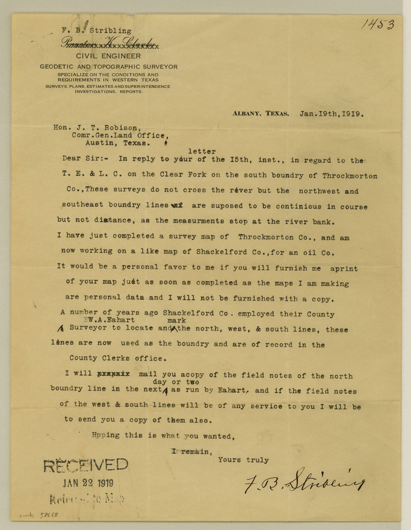
Shackelford County Boundary File 6
[Letter regarding Shackelford-Throckmorton County line; Letter containing summary of Fieldnotes of North line of Shackelford County]
-
Map/Doc
58668
-
Collection
General Map Collection
-
Counties
Shackelford
-
Subjects
County Boundaries
-
Height x Width
11.4 x 8.8 inches
29.0 x 22.4 cm
Part of: General Map Collection
Flight Mission No. DAG-19K, Frame 56, Matagorda County

Print $20.00
- Digital $50.00
Flight Mission No. DAG-19K, Frame 56, Matagorda County
1952
Size 18.5 x 22.3 inches
Map/Doc 86383
Val Verde County Working Sketch 25

Print $20.00
- Digital $50.00
Val Verde County Working Sketch 25
1934
Size 24.2 x 18.2 inches
Map/Doc 72160
Bosque County Working Sketch 21

Print $40.00
- Digital $50.00
Bosque County Working Sketch 21
1984
Size 38.5 x 55.1 inches
Map/Doc 67454
Fort Parker State Park

Print $20.00
- Digital $50.00
Fort Parker State Park
1950
Size 26.0 x 37.8 inches
Map/Doc 73569
East Part of Edwards County

Print $40.00
- Digital $50.00
East Part of Edwards County
1975
Size 56.3 x 41.1 inches
Map/Doc 95488
Wise County Working Sketch 25

Print $40.00
- Digital $50.00
Wise County Working Sketch 25
1983
Size 37.1 x 53.8 inches
Map/Doc 72639
Reeves County Working Sketch 42

Print $20.00
- Digital $50.00
Reeves County Working Sketch 42
1973
Size 46.3 x 31.5 inches
Map/Doc 63485
Gaines County Boundary File 1

Print $90.00
- Digital $50.00
Gaines County Boundary File 1
Size 14.4 x 9.0 inches
Map/Doc 53626
Sherman County Boundary File 4

Print $54.00
- Digital $50.00
Sherman County Boundary File 4
Size 8.9 x 8.5 inches
Map/Doc 58782
Live Oak County Working Sketch 24

Print $20.00
- Digital $50.00
Live Oak County Working Sketch 24
1978
Size 31.9 x 38.2 inches
Map/Doc 70609
Erath County Working Sketch 28

Print $20.00
- Digital $50.00
Erath County Working Sketch 28
1970
Size 31.8 x 31.6 inches
Map/Doc 69109
Houston County Rolled Sketch 12

Print $20.00
- Digital $50.00
Houston County Rolled Sketch 12
Size 11.8 x 18.1 inches
Map/Doc 95396
You may also like
Railroad and County Map of Texas

Print $20.00
- Digital $50.00
Railroad and County Map of Texas
1926
Size 42.9 x 45.2 inches
Map/Doc 65799
Briscoe County Sketch File C

Print $40.00
- Digital $50.00
Briscoe County Sketch File C
1900
Size 20.4 x 35.6 inches
Map/Doc 11000
Wharton County Working Sketch 25

Print $20.00
- Digital $50.00
Wharton County Working Sketch 25
1993
Size 20.0 x 25.5 inches
Map/Doc 72489
Hutchinson County Sketch File 40

Print $32.00
- Digital $50.00
Hutchinson County Sketch File 40
Size 11.3 x 8.9 inches
Map/Doc 27282
Hemphill County Working Sketch 2

Print $20.00
- Digital $50.00
Hemphill County Working Sketch 2
1926
Size 29.0 x 31.1 inches
Map/Doc 66097
Flight Mission No. BRE-2P, Frame 49, Nueces County

Print $20.00
- Digital $50.00
Flight Mission No. BRE-2P, Frame 49, Nueces County
1956
Size 18.3 x 22.4 inches
Map/Doc 86751
Right of Way and Track Map, the Missouri, Kansas and Texas Ry. of Texas operated by the Missouri, Kansas and Texas Ry. of Texas, San Antonio Division

Print $40.00
- Digital $50.00
Right of Way and Track Map, the Missouri, Kansas and Texas Ry. of Texas operated by the Missouri, Kansas and Texas Ry. of Texas, San Antonio Division
1918
Size 25.6 x 57.8 inches
Map/Doc 64582
Map of the Houston and Great Northern R.R. from Trinity River to Palestine

Print $40.00
- Digital $50.00
Map of the Houston and Great Northern R.R. from Trinity River to Palestine
1872
Size 30.3 x 119.9 inches
Map/Doc 64549
Map of Young County

Print $20.00
- Digital $50.00
Map of Young County
Size 25.6 x 29.8 inches
Map/Doc 92023
San Augustine County

Print $20.00
- Digital $50.00
San Augustine County
1901
Size 46.4 x 28.1 inches
Map/Doc 63015
Real County Rolled Sketch 20

Print $20.00
- Digital $50.00
Real County Rolled Sketch 20
2004
Size 24.6 x 35.8 inches
Map/Doc 82573
Presidio County Working Sketch 55

Print $20.00
- Digital $50.00
Presidio County Working Sketch 55
1955
Size 22.0 x 16.9 inches
Map/Doc 71732