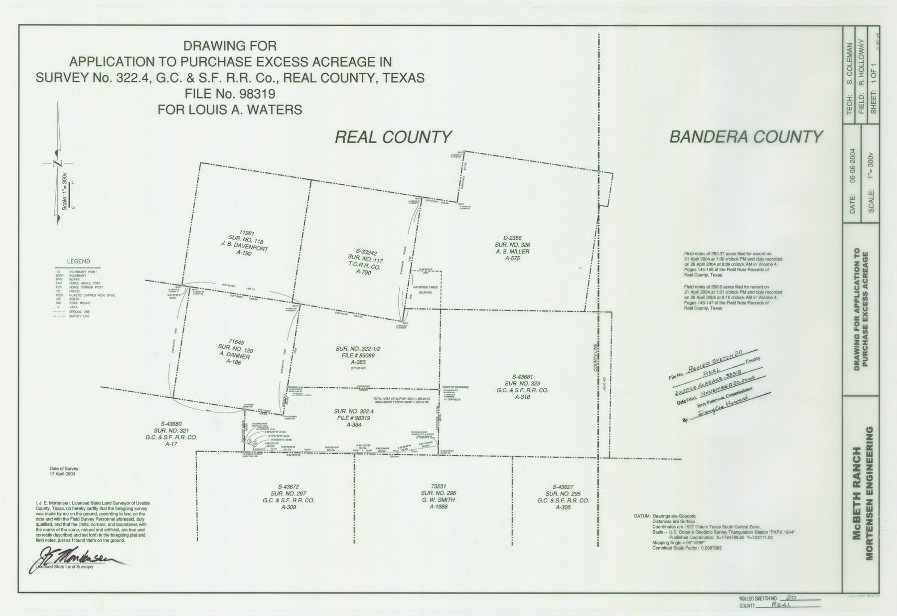
Real County Rolled Sketch 20
Drawing for application to purchase excess acreage in survey no. 322.4, G. C. & S. F. R.R. Co., Real County, Texas, File no. 98319 for Louis A. Waters
-
Map/Doc
82573
-
Collection
General Map Collection
-
Object Dates
2003/4/17 (Survey Date)
2004/11/30 (File Date)
2004/5/6 (Creation Date)
-
People and Organizations
James E. Mortensen (Surveyor/Engineer)
-
Counties
Real
-
Subjects
Surveying Rolled Sketch
-
Height x Width
24.6 x 35.8 inches
62.5 x 90.9 cm
-
Medium
mylar, print
-
Scale
1" = 300 varas
Part of: General Map Collection
Moore County Working Sketch 1

Print $20.00
- Digital $50.00
Moore County Working Sketch 1
1909
Size 32.0 x 32.4 inches
Map/Doc 71183
McLennan County Sketch File 7a

Print $4.00
- Digital $50.00
McLennan County Sketch File 7a
1850
Size 10.3 x 7.4 inches
Map/Doc 31246
Brewster County Rolled Sketch 71

Print $20.00
- Digital $50.00
Brewster County Rolled Sketch 71
1940
Size 29.9 x 42.9 inches
Map/Doc 8491
Newton County Working Sketch 24

Print $20.00
- Digital $50.00
Newton County Working Sketch 24
1953
Size 13.4 x 16.1 inches
Map/Doc 71270
Zavala County Sketch File 45

Print $4.00
- Digital $50.00
Zavala County Sketch File 45
1923
Size 11.5 x 8.8 inches
Map/Doc 41428
Orange County Rolled Sketch 27

Print $20.00
- Digital $50.00
Orange County Rolled Sketch 27
1954
Size 22.3 x 34.5 inches
Map/Doc 7186

Jasper County Sketch File 8 and 9

Print $80.00
- Digital $50.00
Jasper County Sketch File 8 and 9
Size 8.2 x 6.9 inches
Map/Doc 27777
Montague County Sketch File 25

Print $8.00
- Digital $50.00
Montague County Sketch File 25
1942
Size 11.2 x 8.8 inches
Map/Doc 31756
Brooks County Sketch File 5

Print $18.00
- Digital $50.00
Brooks County Sketch File 5
1941
Size 11.3 x 9.0 inches
Map/Doc 16551
Angelina County Working Sketch 39

Print $20.00
- Digital $50.00
Angelina County Working Sketch 39
1959
Size 25.6 x 30.0 inches
Map/Doc 67122
Pecos County Rolled Sketch 91

Print $20.00
- Digital $50.00
Pecos County Rolled Sketch 91
Size 23.6 x 34.7 inches
Map/Doc 9710
You may also like

Amistad International Reservoir on Rio Grande 82

Print $20.00
- Digital $50.00
Amistad International Reservoir on Rio Grande 82
1949
Size 28.5 x 40.2 inches
Map/Doc 75511

Presidio County Working Sketch 31

Print $20.00
- Digital $50.00
Presidio County Working Sketch 31
1946
Size 25.2 x 26.3 inches
Map/Doc 71708
United States - Gulf Coast Texas - Southern part of Laguna Madre

Print $20.00
- Digital $50.00
United States - Gulf Coast Texas - Southern part of Laguna Madre
1941
Size 18.2 x 27.7 inches
Map/Doc 72947
Flight Mission No. BRE-1P, Frame 137, Nueces County

Print $20.00
- Digital $50.00
Flight Mission No. BRE-1P, Frame 137, Nueces County
1956
Size 18.7 x 22.6 inches
Map/Doc 86697
Montague County Working Sketch 41

Print $40.00
- Digital $50.00
Montague County Working Sketch 41
1923
Size 43.3 x 70.1 inches
Map/Doc 65350
[Galveston, Harrisburg & San Antonio Railroad from Cuero to Stockdale]
![64187, [Galveston, Harrisburg & San Antonio Railroad from Cuero to Stockdale], General Map Collection](https://historictexasmaps.com/wmedia_w700/maps/64187.tif.jpg)
Print $20.00
- Digital $50.00
[Galveston, Harrisburg & San Antonio Railroad from Cuero to Stockdale]
1906
Size 13.3 x 32.9 inches
Map/Doc 64187
Ellwood Farms Situated in Hockley, Lamb, and Hale Counties, Texas

Print $20.00
- Digital $50.00
Ellwood Farms Situated in Hockley, Lamb, and Hale Counties, Texas
Size 21.5 x 32.7 inches
Map/Doc 92227
Liberty County Sketch File 32a

Print $4.00
- Digital $50.00
Liberty County Sketch File 32a
Size 9.2 x 7.6 inches
Map/Doc 29965
Smith County Boundary File 80

Print $8.00
- Digital $50.00
Smith County Boundary File 80
Size 9.0 x 6.2 inches
Map/Doc 58797
Medina County Working Sketch 24

Print $20.00
- Digital $50.00
Medina County Working Sketch 24
1984
Size 26.1 x 36.7 inches
Map/Doc 70939