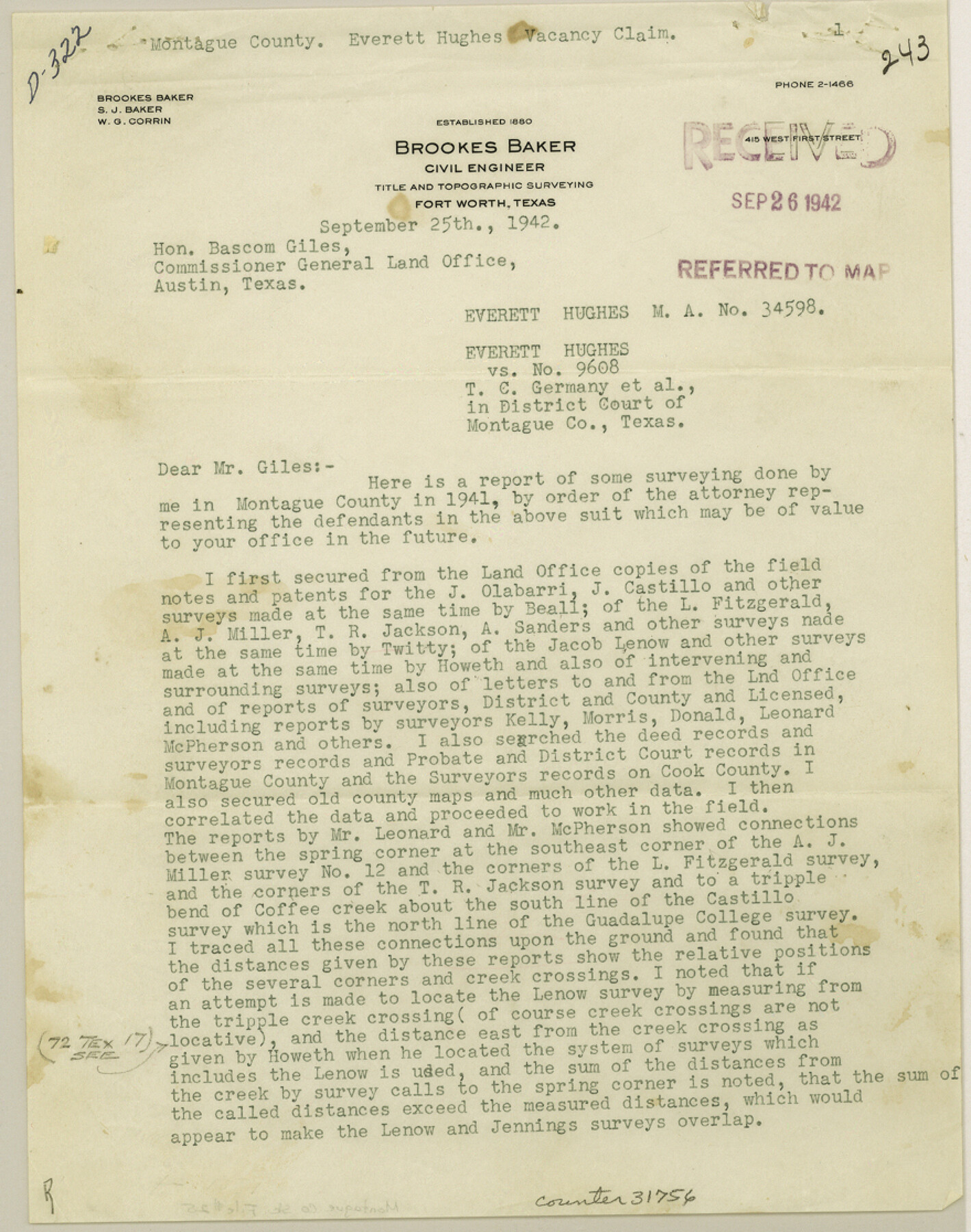
Montague County Sketch File 25
[Report relative to alleged vacancy between the Jacob Lenow and Jas. D. Jennings surveys]
-
Map/Doc
31756
-
Collection
General Map Collection
-
Object Dates
9/25/1942 (Creation Date)
9/26/1942 (File Date)
-
People and Organizations
Brookes Baker (Surveyor/Engineer)
Bascom Giles (GLO Commissioner)
-
Counties
Montague
-
Subjects
Surveying Sketch File
-
Height x Width
11.2 x 8.8 inches
28.5 x 22.4 cm
-
Medium
paper, print
Part of: General Map Collection
Leon County Working Sketch 56

Print $20.00
- Digital $50.00
Leon County Working Sketch 56
1991
Size 32.7 x 26.4 inches
Map/Doc 70456
Dickens County Sketch File 19a

Print $23.00
- Digital $50.00
Dickens County Sketch File 19a
Size 9.6 x 7.8 inches
Map/Doc 21031
Colorado County Sketch File 3a

Print $4.00
- Digital $50.00
Colorado County Sketch File 3a
Size 8.5 x 13.3 inches
Map/Doc 18915
Knox County Boundary File 1

Print $24.00
- Digital $50.00
Knox County Boundary File 1
Size 14.2 x 8.6 inches
Map/Doc 64998
Jefferson County Working Sketch 32

Print $40.00
- Digital $50.00
Jefferson County Working Sketch 32
1981
Size 68.9 x 36.0 inches
Map/Doc 66576
Coast of Texas from Vicinity of Bolivar Point to Rollover Station

Print $40.00
- Digital $50.00
Coast of Texas from Vicinity of Bolivar Point to Rollover Station
1886
Size 32.5 x 54.0 inches
Map/Doc 69920
Presidio County Sketch File P1

Print $4.00
- Digital $50.00
Presidio County Sketch File P1
Size 11.2 x 8.8 inches
Map/Doc 34556
Brazos Santiago, Texas

Print $20.00
- Digital $50.00
Brazos Santiago, Texas
1882
Size 18.3 x 26.0 inches
Map/Doc 72986
Liberty County Working Sketch 36

Print $20.00
- Digital $50.00
Liberty County Working Sketch 36
1948
Size 24.3 x 25.0 inches
Map/Doc 70495
Brewster County Working Sketch 115

Print $40.00
- Digital $50.00
Brewster County Working Sketch 115
1985
Size 49.6 x 43.4 inches
Map/Doc 67715
Maps of Gulf Intracoastal Waterway, Texas - Sabine River to the Rio Grande and connecting waterways including ship channels

Print $20.00
- Digital $50.00
Maps of Gulf Intracoastal Waterway, Texas - Sabine River to the Rio Grande and connecting waterways including ship channels
1966
Size 14.6 x 22.2 inches
Map/Doc 61971
Val Verde County Boundary File 1

Print $6.00
- Digital $50.00
Val Verde County Boundary File 1
Size 14.3 x 8.7 inches
Map/Doc 59572
You may also like
Jefferson County Sketch File 33

Print $32.00
- Digital $50.00
Jefferson County Sketch File 33
1934
Size 8.2 x 7.6 inches
Map/Doc 28197
[G. & M. Block 5]
![91802, [G. & M. Block 5], Twichell Survey Records](https://historictexasmaps.com/wmedia_w700/maps/91802-1.tif.jpg)
Print $20.00
- Digital $50.00
[G. & M. Block 5]
Size 20.3 x 12.5 inches
Map/Doc 91802
Polk County Sketch File 12a

Print $4.00
- Digital $50.00
Polk County Sketch File 12a
Size 6.1 x 6.4 inches
Map/Doc 34148
El Paso County Boundary File 4

Print $12.00
- Digital $50.00
El Paso County Boundary File 4
Size 13.5 x 8.6 inches
Map/Doc 53038
Runnels County Sketch File 38

Print $20.00
Runnels County Sketch File 38
1891
Size 17.6 x 24.9 inches
Map/Doc 12269
A Pocket Guide to Austin, Texas - Area Map and Downtown Map

A Pocket Guide to Austin, Texas - Area Map and Downtown Map
Size 17.2 x 20.2 inches
Map/Doc 94386
Current Miscellaneous File 36

Print $12.00
- Digital $50.00
Current Miscellaneous File 36
Size 10.3 x 12.4 inches
Map/Doc 73952
Old Miscellaneous File 10

Print $4.00
- Digital $50.00
Old Miscellaneous File 10
Size 9.6 x 8.2 inches
Map/Doc 75435
Map of the country adjacent to the left bank of the Rio Grande below Matamoros

Print $20.00
- Digital $50.00
Map of the country adjacent to the left bank of the Rio Grande below Matamoros
1847
Size 18.4 x 27.4 inches
Map/Doc 72869
Crosby County Boundary File 2

Print $64.00
- Digital $50.00
Crosby County Boundary File 2
Size 42.8 x 7.0 inches
Map/Doc 51997
Jeff Davis County Working Sketch 34

Print $20.00
- Digital $50.00
Jeff Davis County Working Sketch 34
1978
Size 20.4 x 38.0 inches
Map/Doc 66529
Dimmit County Sketch File 41

Print $4.00
- Digital $50.00
Dimmit County Sketch File 41
1901
Size 14.6 x 9.1 inches
Map/Doc 21169