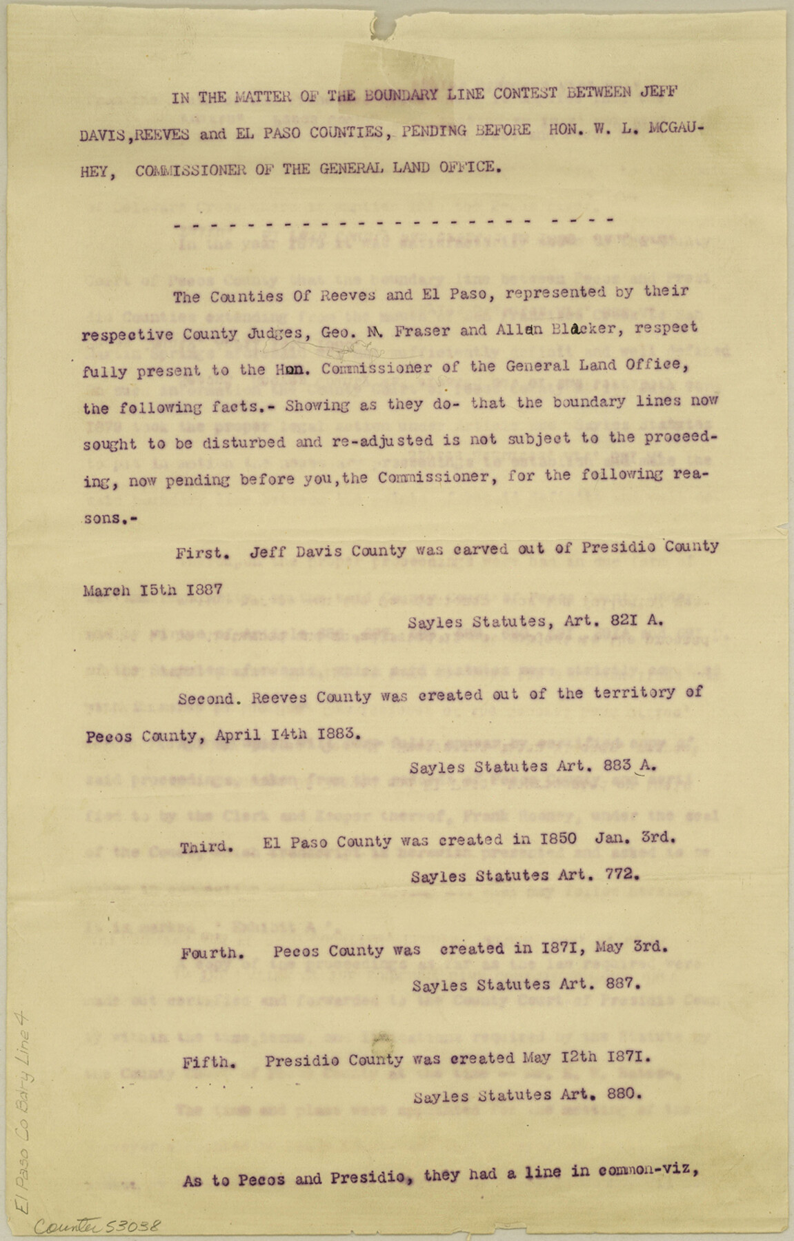
El Paso County Boundary File 4
In the matter of the boundary line contest between Jeff Davis, Reeves and El Paso Counties
-
Map/Doc
53038
-
Collection
General Map Collection
-
Counties
El Paso
-
Subjects
County Boundaries
-
Height x Width
13.5 x 8.6 inches
34.3 x 21.8 cm
Part of: General Map Collection
Navarro County Working Sketch 5

Print $20.00
- Digital $50.00
Navarro County Working Sketch 5
1947
Size 30.3 x 33.2 inches
Map/Doc 71235
Upton County Rolled Sketch 32

Print $20.00
- Digital $50.00
Upton County Rolled Sketch 32
Size 38.6 x 39.0 inches
Map/Doc 10049
Ector County Working Sketch 11

Print $20.00
- Digital $50.00
Ector County Working Sketch 11
1954
Size 24.6 x 37.7 inches
Map/Doc 68854
Duval County Working Sketch 20

Print $20.00
- Digital $50.00
Duval County Working Sketch 20
1940
Size 20.5 x 12.7 inches
Map/Doc 68733
Concho County Sketch File 2

Print $4.00
- Digital $50.00
Concho County Sketch File 2
1859
Size 10.5 x 8.5 inches
Map/Doc 19122
Hays County Sketch File 25a

Print $2.00
- Digital $50.00
Hays County Sketch File 25a
1881
Size 10.2 x 8.0 inches
Map/Doc 26251
Frio County Working Sketch 19

Print $20.00
- Digital $50.00
Frio County Working Sketch 19
1982
Size 36.5 x 34.4 inches
Map/Doc 69293
Portion of States Submerged Area in Matagorda Bay

Print $3.00
- Digital $50.00
Portion of States Submerged Area in Matagorda Bay
1922
Size 12.4 x 10.3 inches
Map/Doc 2954
Hudspeth County Sketch File 29

Print $20.00
- Digital $50.00
Hudspeth County Sketch File 29
1918
Size 22.3 x 21.4 inches
Map/Doc 11804
Wise County Sketch File 13

Print $4.00
- Digital $50.00
Wise County Sketch File 13
Size 9.0 x 15.2 inches
Map/Doc 40546
Tom Green County Rolled Sketch 8

Print $20.00
- Digital $50.00
Tom Green County Rolled Sketch 8
Size 18.3 x 26.0 inches
Map/Doc 7996
Hood County Working Sketch 16

Print $40.00
- Digital $50.00
Hood County Working Sketch 16
1987
Size 45.2 x 71.4 inches
Map/Doc 66210
You may also like
Montgomery County Sketch File 7

Print $35.00
- Digital $50.00
Montgomery County Sketch File 7
1861
Size 8.8 x 7.8 inches
Map/Doc 31785
Southern Part of Laguna Madre

Print $20.00
- Digital $50.00
Southern Part of Laguna Madre
1972
Size 44.3 x 35.6 inches
Map/Doc 73542
Scurry County Rolled Sketch 13

Print $20.00
- Digital $50.00
Scurry County Rolled Sketch 13
2002
Size 19.4 x 19.2 inches
Map/Doc 76417
[Sketch for Mineral Application 26501 - Sabine River, T. A. Oldhausen]
![2832, [Sketch for Mineral Application 26501 - Sabine River, T. A. Oldhausen], General Map Collection](https://historictexasmaps.com/wmedia_w700/maps/2832.tif.jpg)
Print $20.00
- Digital $50.00
[Sketch for Mineral Application 26501 - Sabine River, T. A. Oldhausen]
1931
Size 24.0 x 36.0 inches
Map/Doc 2832
Parker County Rolled Sketch 5

Print $20.00
- Digital $50.00
Parker County Rolled Sketch 5
1987
Size 21.9 x 21.4 inches
Map/Doc 7206

Concho County Rolled Sketch 51

Print $20.00
- Digital $50.00
Concho County Rolled Sketch 51
1967
Size 31.0 x 25.5 inches
Map/Doc 5559
Map of the State of Texas

Print $40.00
- Digital $50.00
Map of the State of Texas
1879
Size 102.7 x 106.6 inches
Map/Doc 16973
Map of Panola County

Print $20.00
- Digital $50.00
Map of Panola County
1882
Size 20.9 x 22.0 inches
Map/Doc 4504
Set of new maps of Austin's Colony by G. Borden, Jr.

Print $20.00
- Digital $50.00
Set of new maps of Austin's Colony by G. Borden, Jr.
1833
Size 25.0 x 17.0 inches
Map/Doc 131
Ward County Sketch File 8

Print $20.00
- Digital $50.00
Ward County Sketch File 8
Size 13.3 x 22.8 inches
Map/Doc 12599
Harris County Sketch File 61

Print $20.00
- Digital $50.00
Harris County Sketch File 61
1927
Size 19.4 x 16.7 inches
Map/Doc 11659