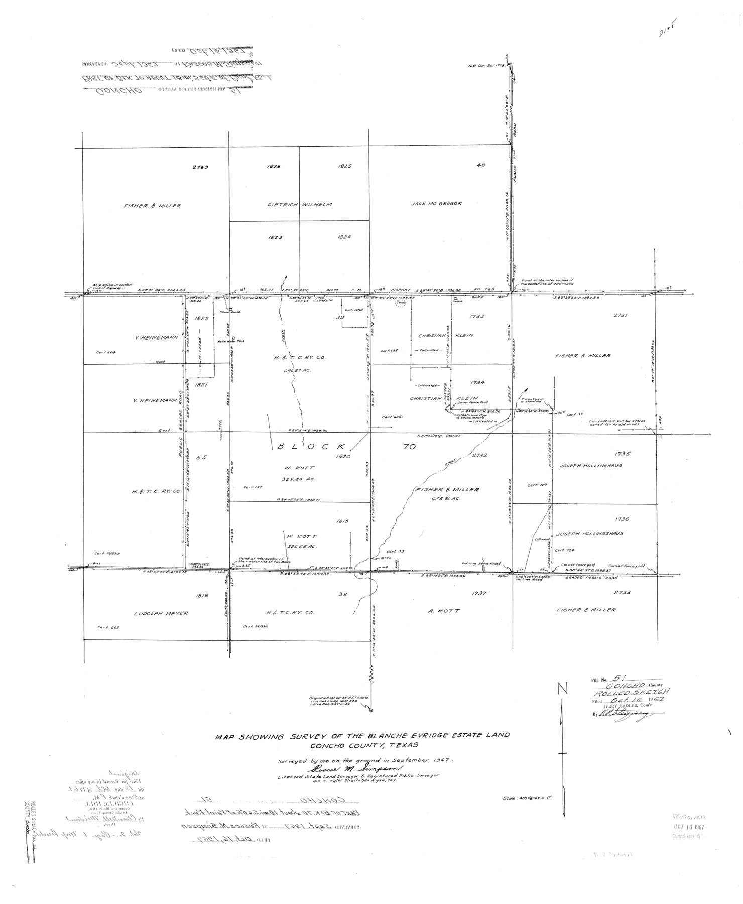
Concho County Rolled Sketch 51
Map showing survey of the Blanche Evridge Estate land, Concho County, Texas
-
Map/Doc
5559
-
Collection
General Map Collection
-
Object Dates
1967 (Creation Date)
1967/10/16 (File Date)
-
People and Organizations
Roscoe M. Simpson (Surveyor/Engineer)
-
Counties
Concho
-
Subjects
Surveying Rolled Sketch
-
Height x Width
31.0 x 25.5 inches
78.7 x 64.8 cm
-
Scale
1" = 400 varas
Part of: General Map Collection
Jeff Davis County Working Sketch 32

Print $40.00
- Digital $50.00
Jeff Davis County Working Sketch 32
1975
Size 66.7 x 43.7 inches
Map/Doc 66527
Map of Matagorda County

Print $20.00
- Digital $50.00
Map of Matagorda County
1865
Size 32.8 x 28.4 inches
Map/Doc 3843
Guadalupe County

Print $20.00
- Digital $50.00
Guadalupe County
1977
Size 35.0 x 45.9 inches
Map/Doc 77297
Louisiana and Texas Intracoastal Waterway - Matagorda-Espiritu Santo and San Antonio Bays, Section 8-9, Survey of 1927-8 - Index Sheet 3

Print $20.00
- Digital $50.00
Louisiana and Texas Intracoastal Waterway - Matagorda-Espiritu Santo and San Antonio Bays, Section 8-9, Survey of 1927-8 - Index Sheet 3
1929
Size 31.0 x 42.8 inches
Map/Doc 61837
Bowie County Rolled Sketch 4

Print $20.00
- Digital $50.00
Bowie County Rolled Sketch 4
Size 46.1 x 43.6 inches
Map/Doc 8456
Armstrong County Sketch File A-5

Print $40.00
- Digital $50.00
Armstrong County Sketch File A-5
1918
Size 18.0 x 28.2 inches
Map/Doc 10846

San Patricio County NRC Article 33.136 Location Key Sheet

Print $20.00
- Digital $50.00
San Patricio County NRC Article 33.136 Location Key Sheet
1975
Size 27.0 x 23.0 inches
Map/Doc 87913
Sherman County Sketch File 5

Print $2.00
- Digital $50.00
Sherman County Sketch File 5
1993
Size 14.6 x 9.0 inches
Map/Doc 36723
Mitchell County Working Sketch 5

Print $40.00
- Digital $50.00
Mitchell County Working Sketch 5
1956
Size 60.4 x 28.2 inches
Map/Doc 71062
Upton County Sketch File 33

Print $20.00
- Digital $50.00
Upton County Sketch File 33
1939
Size 19.4 x 20.8 inches
Map/Doc 12524
Burnet County Sketch File 31

Print $4.00
- Digital $50.00
Burnet County Sketch File 31
1875
Size 12.7 x 8.1 inches
Map/Doc 16748
You may also like
Dimmit County Sketch File 24

Print $4.00
- Digital $50.00
Dimmit County Sketch File 24
1885
Size 13.0 x 8.7 inches
Map/Doc 21140
Jefferson County Rolled Sketch 19

Print $90.00
- Digital $50.00
Jefferson County Rolled Sketch 19
1931
Size 19.1 x 72.7 inches
Map/Doc 9283
Flight Mission No. BRE-2P, Frame 53, Nueces County

Print $20.00
- Digital $50.00
Flight Mission No. BRE-2P, Frame 53, Nueces County
1956
Size 18.4 x 22.2 inches
Map/Doc 86755
Flight Mission No. CUG-1P, Frame 161, Kleberg County

Print $20.00
- Digital $50.00
Flight Mission No. CUG-1P, Frame 161, Kleberg County
1956
Size 18.5 x 22.3 inches
Map/Doc 86168
Coryell County Working Sketch 24

Print $20.00
- Digital $50.00
Coryell County Working Sketch 24
1979
Size 35.5 x 34.5 inches
Map/Doc 68231
[Sketch of surveys in the vicinity of sections 171 and 172 along Pedernales]
![91880, [Sketch of surveys in the vicinity of sections 171 and 172 along Pedernales], Twichell Survey Records](https://historictexasmaps.com/wmedia_w700/maps/91880-1.tif.jpg)
Print $20.00
- Digital $50.00
[Sketch of surveys in the vicinity of sections 171 and 172 along Pedernales]
Size 15.8 x 14.3 inches
Map/Doc 91880
Parmer County

Print $20.00
- Digital $50.00
Parmer County
1926
Size 39.8 x 31.6 inches
Map/Doc 77392
Township No. 3 South Range No. 19 West of the Indian Meridian

Print $20.00
- Digital $50.00
Township No. 3 South Range No. 19 West of the Indian Meridian
1875
Size 19.2 x 24.5 inches
Map/Doc 75182
Flight Mission No. DQO-8K, Frame 21, Galveston County

Print $20.00
- Digital $50.00
Flight Mission No. DQO-8K, Frame 21, Galveston County
1952
Size 18.6 x 22.3 inches
Map/Doc 85144
Map of Ramsey State Farm, Brazoria County, Texas

Print $20.00
- Digital $50.00
Map of Ramsey State Farm, Brazoria County, Texas
Size 29.0 x 37.1 inches
Map/Doc 62997
Corpus Christi Pass

Print $20.00
- Digital $50.00
Corpus Christi Pass
1880
Size 45.5 x 41.0 inches
Map/Doc 2694
Coast Chart No. 210 - Aransas Pass and Corpus Christi Bay with the coast to latitude 27° 12', Texas

Print $20.00
- Digital $50.00
Coast Chart No. 210 - Aransas Pass and Corpus Christi Bay with the coast to latitude 27° 12', Texas
1907
Size 18.4 x 24.2 inches
Map/Doc 73450