Upton County Sketch File 33
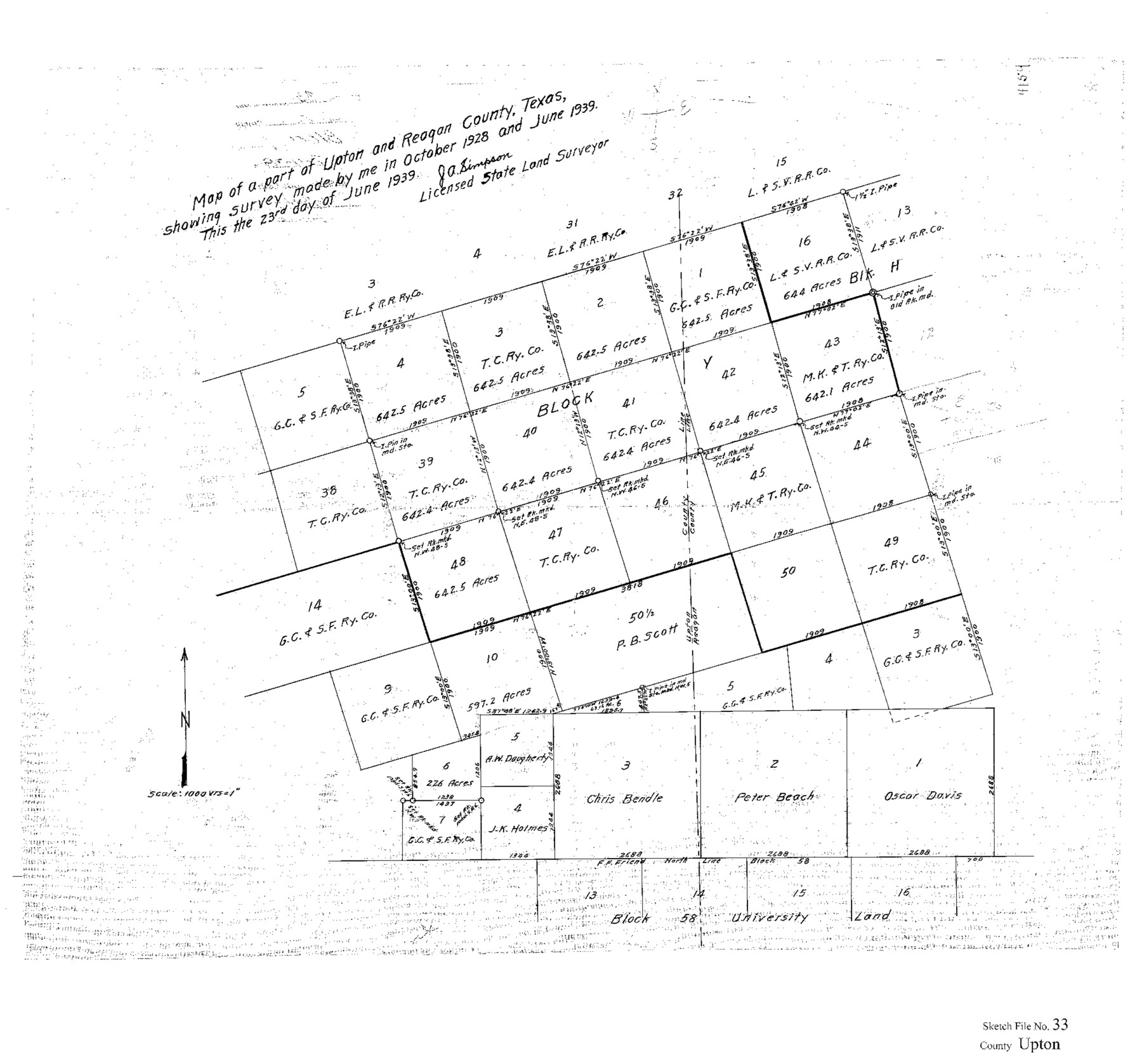
Map of a part of Upton and Reagan County, Texas, showing survey made by me in October 1928 and June 1939. J. A. Simpson.
-
Map/Doc
12524
-
Collection
General Map Collection
-
Object Dates
1939/6/23 (Creation Date)
1939/7/11 (File Date)
1939/6/23 (Creation Date)
1928 (Survey Date)
1939 (Survey Date)
-
People and Organizations
J.A. Simpson (Surveyor/Engineer)
-
Counties
Upton
-
Subjects
Surveying Sketch File
-
Height x Width
19.4 x 20.8 inches
49.3 x 52.8 cm
-
Medium
paper, print
Part of: General Map Collection
Hutchinson County Working Sketch 35

Print $20.00
- Digital $50.00
Hutchinson County Working Sketch 35
1978
Size 27.0 x 22.3 inches
Map/Doc 66395
Hays County Sketch File 16a

Print $4.00
- Digital $50.00
Hays County Sketch File 16a
1871
Size 8.2 x 9.7 inches
Map/Doc 26229
Tarrant County Sketch File 6

Print $4.00
- Digital $50.00
Tarrant County Sketch File 6
1859
Size 6.8 x 8.3 inches
Map/Doc 37682
Lavaca County Rolled Sketch 5

Print $40.00
- Digital $50.00
Lavaca County Rolled Sketch 5
Size 37.0 x 49.1 inches
Map/Doc 10288
Crockett County Working Sketch 6

Print $20.00
- Digital $50.00
Crockett County Working Sketch 6
Size 20.7 x 21.7 inches
Map/Doc 68339
Terrell County Working Sketch 61

Print $20.00
- Digital $50.00
Terrell County Working Sketch 61
1962
Size 20.3 x 34.3 inches
Map/Doc 69582
Cherokee County Sketch File 22a

Print $20.00
- Digital $50.00
Cherokee County Sketch File 22a
Size 17.5 x 14.6 inches
Map/Doc 11072
Irion County Sketch File 1

Print $20.00
- Digital $50.00
Irion County Sketch File 1
1881
Size 43.9 x 18.3 inches
Map/Doc 10615
Polk County Sketch File 24

Print $20.00
- Digital $50.00
Polk County Sketch File 24
Size 14.3 x 30.8 inches
Map/Doc 12193
Northern Part of Laguna Madre

Print $20.00
- Digital $50.00
Northern Part of Laguna Madre
1949
Size 44.6 x 34.9 inches
Map/Doc 73524
Map of Austin's Li[ttle Colony Above the] San [Antonio Road]
![215, Map of Austin's Li[ttle Colony Above the] San [Antonio Road], General Map Collection](https://historictexasmaps.com/wmedia_w700/maps/215.tif.jpg)
Print $20.00
- Digital $50.00
Map of Austin's Li[ttle Colony Above the] San [Antonio Road]
1831
Size 14.2 x 19.3 inches
Map/Doc 215
Calhoun County Rolled Sketch 24

Print $40.00
- Digital $50.00
Calhoun County Rolled Sketch 24
1962
Size 26.0 x 58.3 inches
Map/Doc 5373
You may also like
Crosby County Sketch File 12

Print $4.00
- Digital $50.00
Crosby County Sketch File 12
1895
Size 14.3 x 9.1 inches
Map/Doc 20034
Burma, Thailand, Indochina and Malayan Federation

Print $3.00
- Digital $50.00
Burma, Thailand, Indochina and Malayan Federation
Size 10.7 x 14.6 inches
Map/Doc 92376
Kinney County Sketch File 17

Print $3.00
- Digital $50.00
Kinney County Sketch File 17
1888
Size 11.7 x 16.9 inches
Map/Doc 11942
Blanco County Rolled Sketch 15

Print $20.00
- Digital $50.00
Blanco County Rolled Sketch 15
Size 12.9 x 13.7 inches
Map/Doc 5151
Briscoe County Sketch File 5

Print $40.00
- Digital $50.00
Briscoe County Sketch File 5
Size 29.8 x 26.5 inches
Map/Doc 10994
Mills County Boundary File 1b

Print $4.00
- Digital $50.00
Mills County Boundary File 1b
Size 10.6 x 8.1 inches
Map/Doc 57276
Rand, McNally and Co.'s New Enlarged Scale Railroad and County Map of Texas, Showing Every Railroad Station and Post Office in the State

Print $20.00
- Digital $50.00
Rand, McNally and Co.'s New Enlarged Scale Railroad and County Map of Texas, Showing Every Railroad Station and Post Office in the State
1882
Size 23.7 x 29.8 inches
Map/Doc 2135
Harris County Rolled Sketch 43

Print $20.00
- Digital $50.00
Harris County Rolled Sketch 43
1919
Size 15.3 x 18.9 inches
Map/Doc 6101
[North part H. & T. C. Blk. 5 and PSL Blk. 64]
![90499, [North part H. & T. C. Blk. 5 and PSL Blk. 64], Twichell Survey Records](https://historictexasmaps.com/wmedia_w700/maps/90499-1.tif.jpg)
Print $20.00
- Digital $50.00
[North part H. & T. C. Blk. 5 and PSL Blk. 64]
Size 13.2 x 12.0 inches
Map/Doc 90499
Kimble County Boundary File 4

Print $26.00
- Digital $50.00
Kimble County Boundary File 4
Size 7.5 x 7.3 inches
Map/Doc 64868

Marion County Working Sketch 19

Print $20.00
- Digital $50.00
Marion County Working Sketch 19
1958
Size 29.0 x 23.6 inches
Map/Doc 70795