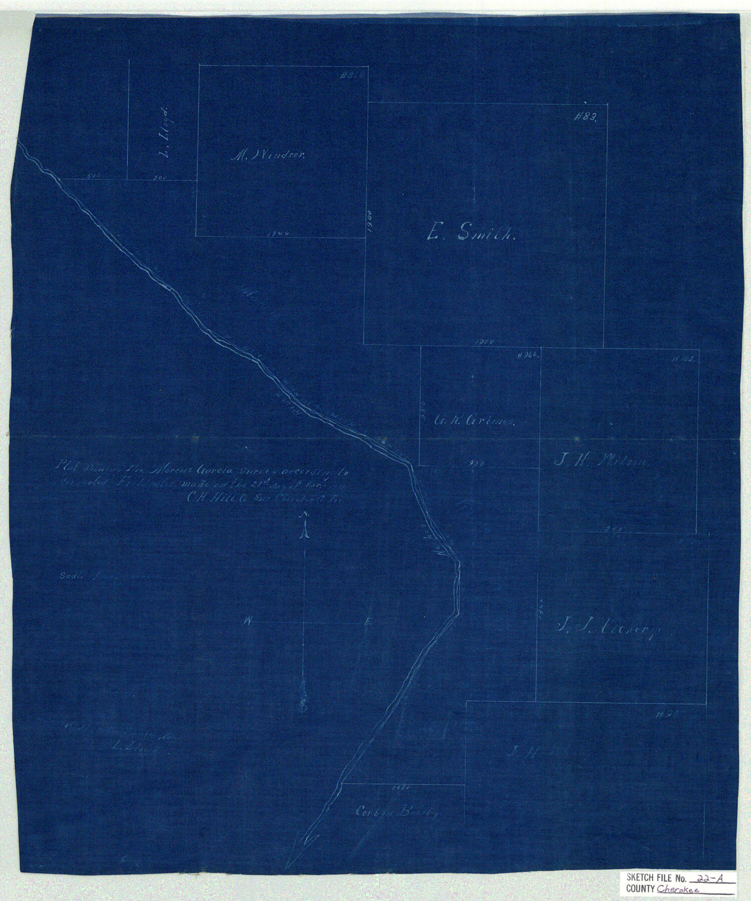
Cherokee County Sketch File 22a
Plat showing the Marcus Garcia survey according to corrected field notes
-
Map/Doc
11072
-
Collection
General Map Collection
-
People and Organizations
C.H. Hill (Surveyor/Engineer)
-
Counties
Cherokee
-
Subjects
Surveying Sketch File
-
Height x Width
17.5 x 14.6 inches
44.5 x 37.1 cm
-
Medium
blueprint/diazo
-
Features
Neches River
Part of: General Map Collection
[Cotton Belt, St. Louis Southwestern Railway of Texas, Alignment through Smith County]
![64386, [Cotton Belt, St. Louis Southwestern Railway of Texas, Alignment through Smith County], General Map Collection](https://historictexasmaps.com/wmedia_w700/maps/64386.tif.jpg)
Print $20.00
- Digital $50.00
[Cotton Belt, St. Louis Southwestern Railway of Texas, Alignment through Smith County]
1903
Size 21.7 x 29.3 inches
Map/Doc 64386
[T. J. Chambers' grant]
![319, [T. J. Chambers' grant], General Map Collection](https://historictexasmaps.com/wmedia_w700/maps/319.tif.jpg)
Print $2.00
- Digital $50.00
[T. J. Chambers' grant]
1847
Size 7.1 x 7.1 inches
Map/Doc 319
Montague County Working Sketch 1

Print $20.00
- Digital $50.00
Montague County Working Sketch 1
Size 18.7 x 32.5 inches
Map/Doc 71067
Austin County Sketch File 4a

Print $8.00
- Digital $50.00
Austin County Sketch File 4a
1881
Size 6.5 x 4.9 inches
Map/Doc 13861
Nautical Chart 885-SC Intracoastal Waterway - Ellender to Galveston Bay, Louisiana-Texas

Print $40.00
- Digital $50.00
Nautical Chart 885-SC Intracoastal Waterway - Ellender to Galveston Bay, Louisiana-Texas
1972
Size 16.1 x 59.4 inches
Map/Doc 69836
Van Zandt County Sketch File 5

Print $22.00
- Digital $50.00
Van Zandt County Sketch File 5
Size 20.5 x 6.3 inches
Map/Doc 39371
Cameron County Rolled Sketch 19

Print $20.00
- Digital $50.00
Cameron County Rolled Sketch 19
1960
Size 27.0 x 20.5 inches
Map/Doc 5469
Runnels County Working Sketch 30b

Print $20.00
- Digital $50.00
Runnels County Working Sketch 30b
Size 23.2 x 25.3 inches
Map/Doc 63627
The Military History of Texas Map!

The Military History of Texas Map!
Size 24.2 x 35.2 inches
Map/Doc 94360
Township 5 South Range 13 West, South Western District, Louisiana

Print $20.00
- Digital $50.00
Township 5 South Range 13 West, South Western District, Louisiana
1879
Size 19.3 x 24.8 inches
Map/Doc 65885
Hemphill County Boundary File 1

Print $18.00
- Digital $50.00
Hemphill County Boundary File 1
Size 9.0 x 3.9 inches
Map/Doc 54612
Callahan County Sketch File 10

Print $40.00
- Digital $50.00
Callahan County Sketch File 10
Size 21.7 x 24.7 inches
Map/Doc 11039
You may also like
Map of the Columbia and Wharton Division of the Galveston & Eagle Pass Airline Railway

Print $20.00
- Digital $50.00
Map of the Columbia and Wharton Division of the Galveston & Eagle Pass Airline Railway
1881
Size 30.3 x 17.3 inches
Map/Doc 64483
[Sketch Showing Railroad land surveys in Dallam & Sherman Counties, Texas]
![75786, [Sketch Showing Railroad land surveys in Dallam & Sherman Counties, Texas], Maddox Collection](https://historictexasmaps.com/wmedia_w700/maps/75786.tif.jpg)
Print $20.00
- Digital $50.00
[Sketch Showing Railroad land surveys in Dallam & Sherman Counties, Texas]
Size 19.4 x 13.4 inches
Map/Doc 75786
Oldham County Sketch File 8

Print $4.00
- Digital $50.00
Oldham County Sketch File 8
Size 7.9 x 11.9 inches
Map/Doc 33239
Right of Way and Track Map, Texas & New Orleans R.R. operated by the T. & N. O. R.R. Co., Rusk Branch

Print $40.00
- Digital $50.00
Right of Way and Track Map, Texas & New Orleans R.R. operated by the T. & N. O. R.R. Co., Rusk Branch
1918
Size 24.7 x 56.2 inches
Map/Doc 64243
Flight Mission No. DIX-6P, Frame 114, Aransas County

Print $20.00
- Digital $50.00
Flight Mission No. DIX-6P, Frame 114, Aransas County
1956
Size 19.1 x 23.0 inches
Map/Doc 83820
Kleberg County Rolled Sketch 10-19

Print $20.00
- Digital $50.00
Kleberg County Rolled Sketch 10-19
1952
Size 38.2 x 36.7 inches
Map/Doc 9379
Webb County Sketch File 8-1

Print $20.00
- Digital $50.00
Webb County Sketch File 8-1
1929
Size 38.3 x 31.1 inches
Map/Doc 10429
[Galveston, Harrisburg & San Antonio Railroad from Cuero to Stockdale]
![64192, [Galveston, Harrisburg & San Antonio Railroad from Cuero to Stockdale], General Map Collection](https://historictexasmaps.com/wmedia_w700/maps/64192.tif.jpg)
Print $20.00
- Digital $50.00
[Galveston, Harrisburg & San Antonio Railroad from Cuero to Stockdale]
1907
Size 14.1 x 34.1 inches
Map/Doc 64192
Crockett County Sketch File A1, A3, D, and DA2

Print $44.00
- Digital $50.00
Crockett County Sketch File A1, A3, D, and DA2
Size 14.3 x 8.8 inches
Map/Doc 19626
Flight Mission No. BRE-2G, Frame 118, Nueces County

Print $20.00
- Digital $50.00
Flight Mission No. BRE-2G, Frame 118, Nueces County
1950
Size 18.4 x 18.2 inches
Map/Doc 86623
Flight Mission No. DQO-2K, Frame 134, Galveston County

Print $20.00
- Digital $50.00
Flight Mission No. DQO-2K, Frame 134, Galveston County
1952
Size 18.7 x 22.4 inches
Map/Doc 85031
Aransas County Sketch File 13

Print $4.00
- Digital $50.00
Aransas County Sketch File 13
Size 7.0 x 8.4 inches
Map/Doc 13126