Crockett County Sketch File A1, A3, D, and DA2
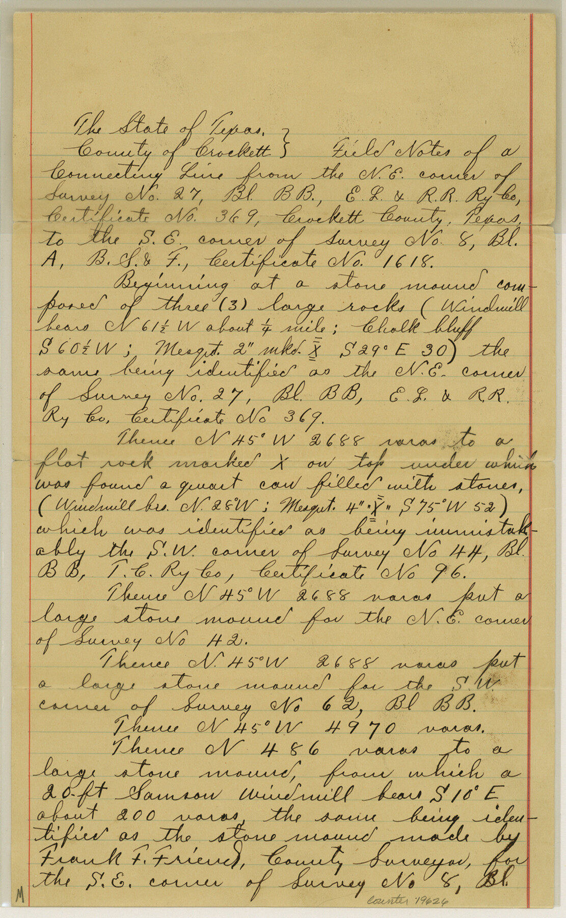
[Field notes of various connecting lines]
-
Map/Doc
19626
-
Collection
General Map Collection
-
Object Dates
1904/6/13 (Survey Date)
1904/10/17 (File Date)
1903/8/29 (Survey Date)
1903/9/28 (Survey Date)
1903/10/3 (File Date)
1904/10/10 (File Date)
-
People and Organizations
Fred Boscol (Chainman)
Dave Parker (Chainman)
Archey Shirley (Chainman)
Jose Longoria (Chainman)
Frank F. Friend (Surveyor/Engineer)
Claude Parker (Chainman)
O.R. Parker (Chainman)
Chas. E. Davidson (Surveyor/Engineer)
-
Counties
Crockett Reagan
-
Subjects
Surveying Sketch File
-
Height x Width
14.3 x 8.8 inches
36.3 x 22.4 cm
-
Medium
paper, manuscript
-
Features
Fort Lancaster
Howard Creek
Pecos River
Grierson Spring
Part of: General Map Collection
Orange County Rolled Sketch 24

Print $245.00
- Digital $50.00
Orange County Rolled Sketch 24
1950
Size 10.5 x 15.4 inches
Map/Doc 47946
Hutchinson County Rolled Sketch 44-8

Print $20.00
- Digital $50.00
Hutchinson County Rolled Sketch 44-8
2002
Size 24.0 x 36.0 inches
Map/Doc 77544
Upshur County Working Sketch 15, revised

Print $20.00
- Digital $50.00
Upshur County Working Sketch 15, revised
1996
Size 43.3 x 37.4 inches
Map/Doc 78217
Flight Mission No. CUG-3P, Frame 90, Kleberg County

Print $20.00
- Digital $50.00
Flight Mission No. CUG-3P, Frame 90, Kleberg County
1956
Size 18.6 x 22.3 inches
Map/Doc 86260
Coke County Sketch File 31

Print $4.00
- Digital $50.00
Coke County Sketch File 31
Size 14.1 x 8.8 inches
Map/Doc 18643
Culberson County Working Sketch Graphic Index, Sheet B (Sketches 41 to Most Recent)

Print $40.00
- Digital $50.00
Culberson County Working Sketch Graphic Index, Sheet B (Sketches 41 to Most Recent)
1943
Size 52.5 x 32.5 inches
Map/Doc 76515
Colorado County Working Sketch 23

Print $20.00
- Digital $50.00
Colorado County Working Sketch 23
1967
Size 38.0 x 32.9 inches
Map/Doc 68123
Calhoun County Sketch File 17

Print $4.00
- Digital $50.00
Calhoun County Sketch File 17
Size 5.1 x 8.4 inches
Map/Doc 35984
San Patricio County NRC Article 33.136 Sketch 4

Print $3.00
- Digital $50.00
San Patricio County NRC Article 33.136 Sketch 4
Size 11.0 x 17.0 inches
Map/Doc 94695
[Sketch for Mineral Application 16700 - Pecos River Bed]
![2806, [Sketch for Mineral Application 16700 - Pecos River Bed], General Map Collection](https://historictexasmaps.com/wmedia_w700/maps/2806.tif.jpg)
Print $20.00
- Digital $50.00
[Sketch for Mineral Application 16700 - Pecos River Bed]
1927
Size 20.3 x 29.1 inches
Map/Doc 2806
Hudspeth County Working Sketch 57

Print $20.00
- Digital $50.00
Hudspeth County Working Sketch 57
1992
Size 9.6 x 26.5 inches
Map/Doc 66342
Crockett County Rolled Sketch 48

Print $20.00
- Digital $50.00
Crockett County Rolled Sketch 48
1939
Size 30.0 x 40.3 inches
Map/Doc 8712
You may also like
Red River County Sketch File 10

Print $15.00
- Digital $50.00
Red River County Sketch File 10
1863
Size 9.1 x 7.4 inches
Map/Doc 35121
Brewster County Working Sketch 10

Print $20.00
- Digital $50.00
Brewster County Working Sketch 10
1910
Size 17.8 x 16.8 inches
Map/Doc 67543

[Sketch for Mineral Application 15273 - Sabine River Bed]
![65575, [Sketch for Mineral Application 15273 - Sabine River Bed], General Map Collection](https://historictexasmaps.com/wmedia_w700/maps/65575-GC.tif.jpg)
Print $20.00
- Digital $50.00
[Sketch for Mineral Application 15273 - Sabine River Bed]
1926
Size 28.2 x 45.5 inches
Map/Doc 65575
Map of Stephens County

Print $20.00
- Digital $50.00
Map of Stephens County
1897
Size 42.8 x 37.5 inches
Map/Doc 78394
[Corpus Christi Bay, Padre Island, Mustang Island, Laguna de la Madre, King and Kenedy's Pasture]
![73042, [Corpus Christi Bay, Padre Island, Mustang Island, Laguna de la Madre, King and Kenedy's Pasture], General Map Collection](https://historictexasmaps.com/wmedia_w700/maps/73042.tif.jpg)
Print $20.00
- Digital $50.00
[Corpus Christi Bay, Padre Island, Mustang Island, Laguna de la Madre, King and Kenedy's Pasture]
Size 26.2 x 18.2 inches
Map/Doc 73042
Umbarger in Randall County, Texas

Print $20.00
- Digital $50.00
Umbarger in Randall County, Texas
1905
Size 31.9 x 30.8 inches
Map/Doc 92158
Flight Mission No. BRA-7M, Frame 147, Jefferson County

Print $20.00
- Digital $50.00
Flight Mission No. BRA-7M, Frame 147, Jefferson County
1953
Size 16.2 x 15.9 inches
Map/Doc 85541
Cherokee County

Print $40.00
- Digital $50.00
Cherokee County
1933
Size 57.0 x 38.8 inches
Map/Doc 77236
Hidalgo County Rolled Sketch 13

Print $20.00
- Digital $50.00
Hidalgo County Rolled Sketch 13
1960
Size 19.0 x 31.4 inches
Map/Doc 6212
[Capitol Leagues 225-238]
![90675, [Capitol Leagues 225-238], Twichell Survey Records](https://historictexasmaps.com/wmedia_w700/maps/90675-1.tif.jpg)
Print $20.00
- Digital $50.00
[Capitol Leagues 225-238]
Size 23.1 x 15.5 inches
Map/Doc 90675
Flight Mission No. CGI-4N, Frame 26, Cameron County

Print $20.00
- Digital $50.00
Flight Mission No. CGI-4N, Frame 26, Cameron County
1954
Size 18.8 x 22.3 inches
Map/Doc 84659