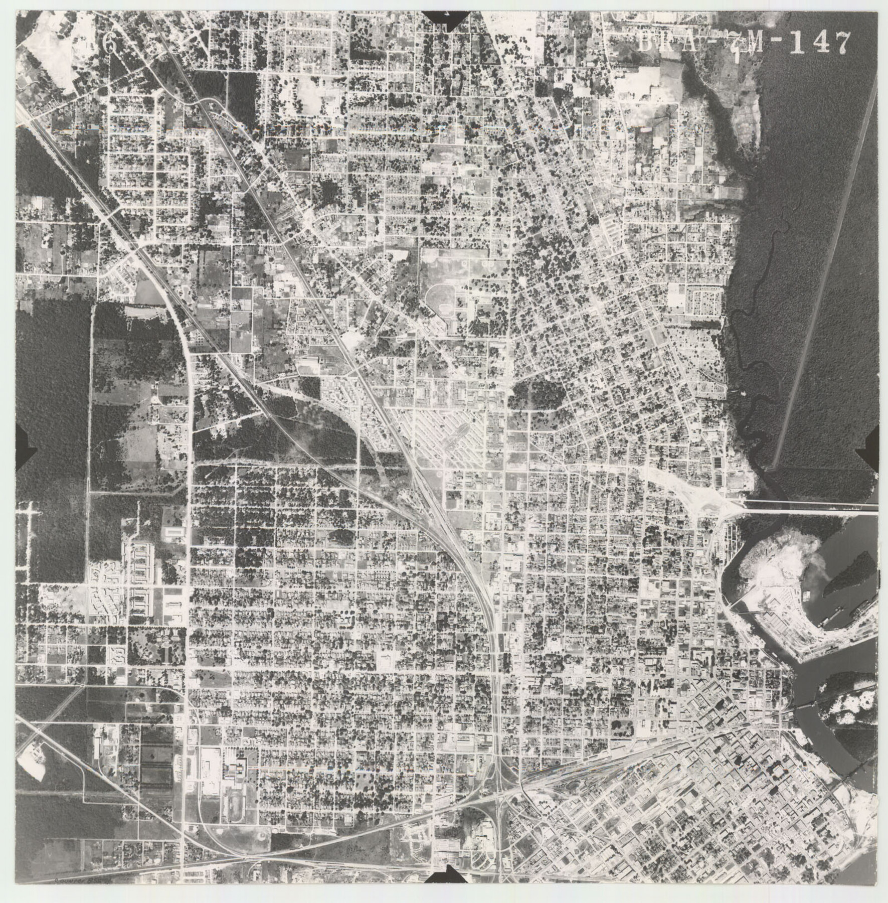
Flight Mission No. BRA-7M, Frame 147, Jefferson County
BRA-7M-147
-
Map/Doc
85541
-
Collection
General Map Collection
-
Object Dates
1953/4/16 (Creation Date)
-
People and Organizations
U. S. Department of Agriculture (Publisher)
-
Counties
Jefferson
-
Subjects
Aerial Photograph
-
Height x Width
16.2 x 15.9 inches
41.1 x 40.4 cm
-
Comments
Flown by Jack Ammann Photogrammetric Engineers of San Antonio, Texas.
Part of: General Map Collection
Harris County Sketch File 80a

Print $20.00
- Digital $50.00
Harris County Sketch File 80a
1892
Size 27.8 x 17.6 inches
Map/Doc 11667
Edwards County Rolled Sketch 31

Print $20.00
- Digital $50.00
Edwards County Rolled Sketch 31
1982
Size 30.5 x 39.4 inches
Map/Doc 8849
Brewster County Working Sketch 68

Print $20.00
- Digital $50.00
Brewster County Working Sketch 68
1958
Size 23.3 x 22.6 inches
Map/Doc 67669
Navarro County Working Sketch 17

Print $20.00
- Digital $50.00
Navarro County Working Sketch 17
2008
Size 35.3 x 36.1 inches
Map/Doc 88812
Reeves County Working Sketch 5

Print $20.00
- Digital $50.00
Reeves County Working Sketch 5
1938
Size 38.0 x 32.4 inches
Map/Doc 63448
Map of Bryan, Brazos County, Texas

Print $20.00
- Digital $50.00
Map of Bryan, Brazos County, Texas
1915
Size 18.5 x 24.6 inches
Map/Doc 3210
Harris County Sketch File 69a

Print $20.00
- Digital $50.00
Harris County Sketch File 69a
1938
Size 19.4 x 21.3 inches
Map/Doc 11663
Dallas County Sketch File 26

Print $20.00
- Digital $50.00
Dallas County Sketch File 26
1942
Size 24.9 x 18.9 inches
Map/Doc 11289
Hartley County Sketch File 6

Print $20.00
- Digital $50.00
Hartley County Sketch File 6
Size 30.5 x 25.6 inches
Map/Doc 11698
Liberty County Sketch File 32

Print $8.00
- Digital $50.00
Liberty County Sketch File 32
1872
Size 10.3 x 8.2 inches
Map/Doc 29961
Right of Way and Track Map, Dayton-Goose Creek Ry. Co., Station 0+00 to Station 190+00

Print $40.00
- Digital $50.00
Right of Way and Track Map, Dayton-Goose Creek Ry. Co., Station 0+00 to Station 190+00
1917
Size 24.8 x 56.6 inches
Map/Doc 64365
Motley County Sketch File 32 (S)

Print $4.00
- Digital $50.00
Motley County Sketch File 32 (S)
Size 11.3 x 8.7 inches
Map/Doc 32215
You may also like
Nueces County Working Sketch Graphic Index

Print $20.00
- Digital $50.00
Nueces County Working Sketch Graphic Index
1913
Size 24.0 x 32.3 inches
Map/Doc 76655
Mason County Rolled Sketch 2

Print $20.00
- Digital $50.00
Mason County Rolled Sketch 2
1952
Size 32.9 x 26.7 inches
Map/Doc 6675
General Highway Map, Houston County, Texas

Print $20.00
General Highway Map, Houston County, Texas
1961
Size 24.7 x 18.2 inches
Map/Doc 79525
Montgomery County Working Sketch 41

Print $20.00
- Digital $50.00
Montgomery County Working Sketch 41
1955
Size 22.9 x 23.6 inches
Map/Doc 71148
Flight Mission No. BRA-8M, Frame 144, Jefferson County

Print $20.00
- Digital $50.00
Flight Mission No. BRA-8M, Frame 144, Jefferson County
1953
Size 18.8 x 22.6 inches
Map/Doc 85636
Map of Van Zandt County

Print $20.00
- Digital $50.00
Map of Van Zandt County
1853
Size 19.4 x 20.6 inches
Map/Doc 16957
General Highway Map, Midland County, Texas

Print $20.00
General Highway Map, Midland County, Texas
1940
Size 18.2 x 24.5 inches
Map/Doc 79197
Orange County NRC Article 33.136 Sketch 6

Print $42.00
Orange County NRC Article 33.136 Sketch 6
2025
Map/Doc 97430
A Map of the United States of Mexico as organized and defined by the several Acts of the Congress of that Republic

Print $20.00
- Digital $50.00
A Map of the United States of Mexico as organized and defined by the several Acts of the Congress of that Republic
1847
Size 24.3 x 30.6 inches
Map/Doc 93876
[Pacific & Santa Fe Railroad through Fort Stockton]
![64770, [Pacific & Santa Fe Railroad through Fort Stockton], General Map Collection](https://historictexasmaps.com/wmedia_w700/maps/64770.tif.jpg)
Print $20.00
- Digital $50.00
[Pacific & Santa Fe Railroad through Fort Stockton]
Size 18.4 x 20.5 inches
Map/Doc 64770
A Geographically Correct Map of the State of Texas

Print $20.00
- Digital $50.00
A Geographically Correct Map of the State of Texas
1878
Size 19.5 x 21.0 inches
Map/Doc 95757
Uvalde County Working Sketch 23

Print $20.00
- Digital $50.00
Uvalde County Working Sketch 23
1952
Size 32.0 x 26.6 inches
Map/Doc 72093