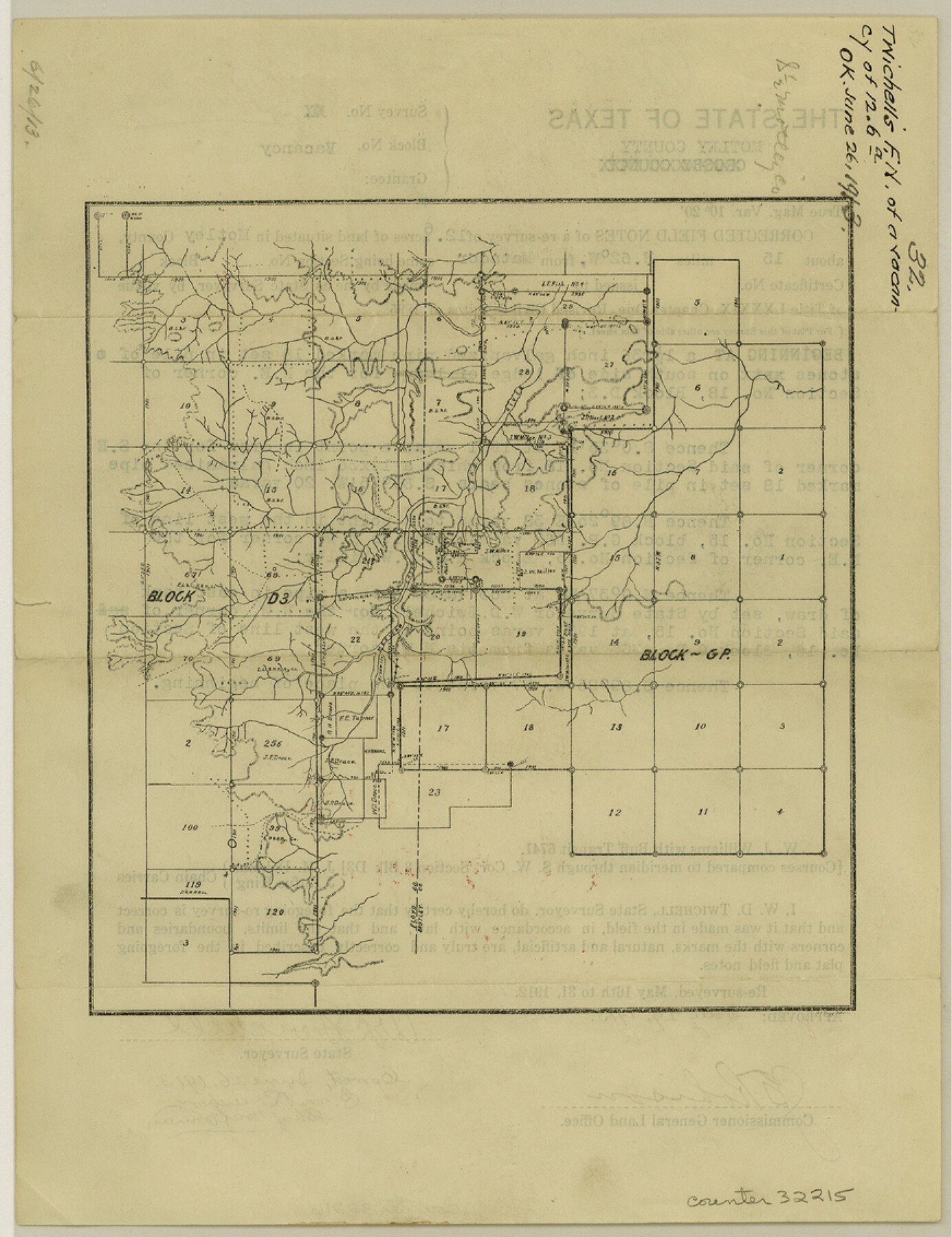
Motley County Sketch File 32 (S)
[Field notes of a vacancy of 12.6 acres]
-
Map/Doc
32215
-
Collection
General Map Collection
-
Object Dates
6/26/1913 (File Date)
5/16/1912 (Survey Date)
5/31/1912 (Survey Date)
-
People and Organizations
W.D. Twichell (Surveyor/Engineer)
E. von Rosenberg (Draftsman)
-
Counties
Motley Floyd
-
Subjects
Surveying Sketch File
-
Height x Width
11.3 x 8.7 inches
28.7 x 22.1 cm
-
Medium
paper, etching/engraving/lithograph
-
Features
Pease River
Mexican Creek
Part of: General Map Collection
El Paso County Sketch File 16

Print $20.00
- Digital $50.00
El Paso County Sketch File 16
1885
Size 31.0 x 36.0 inches
Map/Doc 10446
Township 1 North Range 11 West, North Western District, Louisiana

Print $20.00
- Digital $50.00
Township 1 North Range 11 West, North Western District, Louisiana
1884
Size 19.6 x 24.7 inches
Map/Doc 65878
Kimble County

Print $40.00
- Digital $50.00
Kimble County
1890
Size 38.8 x 58.1 inches
Map/Doc 78414
[Map showing the location of the Pecos Valley Railway through H. &. G. N. R.R. Co. Land in Reeves Co., Texas]
![64707, [Map showing the location of the Pecos Valley Railway through H. &. G. N. R.R. Co. Land in Reeves Co., Texas], General Map Collection](https://historictexasmaps.com/wmedia_w700/maps/64707.tif.jpg)
Print $40.00
- Digital $50.00
[Map showing the location of the Pecos Valley Railway through H. &. G. N. R.R. Co. Land in Reeves Co., Texas]
1891
Size 39.1 x 123.6 inches
Map/Doc 64707
Calhoun County NRC Article 33.136 Sketch 11

Digital $50.00
Calhoun County NRC Article 33.136 Sketch 11
2023
Map/Doc 97255
Rand, McNally and Co.'s New Enlarged Scale Railroad and County Map of Texas, Showing Every Railroad Station and Post Office in the State

Print $20.00
- Digital $50.00
Rand, McNally and Co.'s New Enlarged Scale Railroad and County Map of Texas, Showing Every Railroad Station and Post Office in the State
1882
Size 23.7 x 29.8 inches
Map/Doc 2135
Hudspeth County Working Sketch 24

Print $40.00
- Digital $50.00
Hudspeth County Working Sketch 24
1967
Size 46.0 x 54.9 inches
Map/Doc 66306
Mason County Sketch File 21

Print $6.00
- Digital $50.00
Mason County Sketch File 21
Size 15.7 x 10.9 inches
Map/Doc 30717
Flight Mission No. DAG-24K, Frame 46, Matagorda County

Print $20.00
- Digital $50.00
Flight Mission No. DAG-24K, Frame 46, Matagorda County
1953
Size 18.5 x 22.2 inches
Map/Doc 86533
[Cotton Belt, St. Louis Southwestern Railway of Texas, Alignment through Smith County]
![64385, [Cotton Belt, St. Louis Southwestern Railway of Texas, Alignment through Smith County], General Map Collection](https://historictexasmaps.com/wmedia_w700/maps/64385.tif.jpg)
Print $20.00
- Digital $50.00
[Cotton Belt, St. Louis Southwestern Railway of Texas, Alignment through Smith County]
1903
Size 21.6 x 29.8 inches
Map/Doc 64385
Brewster County Working Sketch 58

Print $20.00
- Digital $50.00
Brewster County Working Sketch 58
1955
Size 19.8 x 21.7 inches
Map/Doc 67659
Knox County Rolled Sketch 9

Print $20.00
- Digital $50.00
Knox County Rolled Sketch 9
Size 26.1 x 33.0 inches
Map/Doc 9407
You may also like
Comanche County Sketch File 8

Print $4.00
- Digital $50.00
Comanche County Sketch File 8
1853
Size 13.1 x 8.2 inches
Map/Doc 19066
Flight Mission No. DQO-7K, Frame 99, Galveston County

Print $20.00
- Digital $50.00
Flight Mission No. DQO-7K, Frame 99, Galveston County
1952
Size 18.7 x 22.5 inches
Map/Doc 85114
Andrews County Working Sketch 19

Print $20.00
- Digital $50.00
Andrews County Working Sketch 19
1964
Size 24.9 x 23.5 inches
Map/Doc 67065
[Surveys along the Colorado and Navidad Rivers]
![60, [Surveys along the Colorado and Navidad Rivers], General Map Collection](https://historictexasmaps.com/wmedia_w700/maps/60.tif.jpg)
Print $20.00
- Digital $50.00
[Surveys along the Colorado and Navidad Rivers]
1840
Size 28.6 x 22.5 inches
Map/Doc 60
Map of Orange County

Print $20.00
- Digital $50.00
Map of Orange County
1895
Size 15.5 x 16.2 inches
Map/Doc 3932
Grayson County Sketch File 22

Print $4.00
- Digital $50.00
Grayson County Sketch File 22
1871
Size 10.4 x 8.4 inches
Map/Doc 24501
Map of the State of Louisiana engraved for Mitchell's new intermediate geography, Louisiana Edition (Inset: Vicinity of New Orleans)

Print $20.00
- Digital $50.00
Map of the State of Louisiana engraved for Mitchell's new intermediate geography, Louisiana Edition (Inset: Vicinity of New Orleans)
1885
Size 9.0 x 12.2 inches
Map/Doc 93533
Map of Brazoria

Print $20.00
- Digital $50.00
Map of Brazoria
1863
Size 27.4 x 27.3 inches
Map/Doc 1013
Culberson County Working Sketch 80

Print $40.00
- Digital $50.00
Culberson County Working Sketch 80
1978
Size 56.4 x 43.4 inches
Map/Doc 68534
Cooke County Sketch File 42

Print $8.00
- Digital $50.00
Cooke County Sketch File 42
1940
Size 14.3 x 8.8 inches
Map/Doc 19316
Tyler County Working Sketch 12

Print $20.00
- Digital $50.00
Tyler County Working Sketch 12
1942
Size 21.2 x 31.7 inches
Map/Doc 69482
Mrs. John H. Dean Ranch, Cochran County, Texas

Print $20.00
- Digital $50.00
Mrs. John H. Dean Ranch, Cochran County, Texas
Size 25.4 x 21.1 inches
Map/Doc 92516