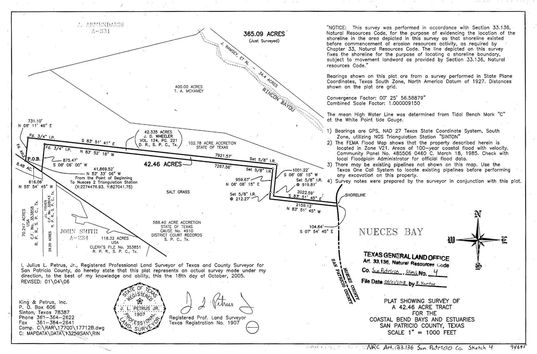
San Patricio County NRC Article 33.136 Sketch 4
Plat showing survey of a 42.46 acre tract for the Coastal Bend Bays and Estuaries
-
Map/Doc
94695
-
Collection
General Map Collection
-
Object Dates
2005/10/18 (Survey Date)
2006/1/4 (Revision Date)
2018/6/21 (File Date)
-
People and Organizations
Julius L. Petrus, Jr. (Surveyor/Engineer)
-
Counties
San Patricio
-
Subjects
Surveying CBS
-
Height x Width
11.0 x 17.0 inches
27.9 x 43.2 cm
-
Medium
mylar, print
Part of: General Map Collection
Gonzales County Working Sketch 10

Print $20.00
- Digital $50.00
Gonzales County Working Sketch 10
1981
Size 18.9 x 14.7 inches
Map/Doc 63226
Hood County Rolled Sketch 1

Print $20.00
- Digital $50.00
Hood County Rolled Sketch 1
1946
Size 31.9 x 38.6 inches
Map/Doc 9177
Flight Mission No. DQO-12K, Frame 36, Galveston County

Print $20.00
- Digital $50.00
Flight Mission No. DQO-12K, Frame 36, Galveston County
1952
Size 18.8 x 22.6 inches
Map/Doc 85227
Gillespie County Working Sketch 13

Print $20.00
- Digital $50.00
Gillespie County Working Sketch 13
2008
Size 22.8 x 31.8 inches
Map/Doc 88831
Young County Sketch File 14

Print $20.00
- Digital $50.00
Young County Sketch File 14
1895
Size 10.9 x 27.3 inches
Map/Doc 12712
Flight Mission No. BQR-13K, Frame 25, Brazoria County

Print $20.00
- Digital $50.00
Flight Mission No. BQR-13K, Frame 25, Brazoria County
1952
Size 18.8 x 22.4 inches
Map/Doc 84073
Henderson County Sketch File 6

Print $4.00
- Digital $50.00
Henderson County Sketch File 6
1857
Size 10.0 x 8.1 inches
Map/Doc 26327
Gaines County Rolled Sketch 6

Print $20.00
- Digital $50.00
Gaines County Rolled Sketch 6
1913
Size 30.5 x 45.4 inches
Map/Doc 5927
Kent County Working Sketch 18

Print $20.00
- Digital $50.00
Kent County Working Sketch 18
1974
Size 33.5 x 31.5 inches
Map/Doc 70025
Flight Mission No. DIX-5P, Frame 142, Aransas County

Print $20.00
- Digital $50.00
Flight Mission No. DIX-5P, Frame 142, Aransas County
1956
Size 18.0 x 18.0 inches
Map/Doc 83803
Henderson County Sketch File 11

Print $2.00
- Digital $50.00
Henderson County Sketch File 11
Size 8.5 x 3.7 inches
Map/Doc 26348
Morris County Working Sketch Graphic Index

Print $20.00
- Digital $50.00
Morris County Working Sketch Graphic Index
1948
Size 42.8 x 20.1 inches
Map/Doc 76649
You may also like
Harris County Rolled Sketch WB

Print $20.00
- Digital $50.00
Harris County Rolled Sketch WB
1916
Size 15.5 x 21.1 inches
Map/Doc 6147
Donley County Working Sketch 3

Print $40.00
- Digital $50.00
Donley County Working Sketch 3
Size 58.7 x 44.8 inches
Map/Doc 68736
Hemphill County Rolled Sketch 8

Print $20.00
- Digital $50.00
Hemphill County Rolled Sketch 8
1903
Size 22.7 x 30.5 inches
Map/Doc 6191
General Highway Map, Sherman County, Texas

Print $20.00
General Highway Map, Sherman County, Texas
1961
Size 18.2 x 24.8 inches
Map/Doc 79653
Brown County Sketch File 2

Print $4.00
- Digital $50.00
Brown County Sketch File 2
Size 11.8 x 8.1 inches
Map/Doc 16582
Hays County Sketch File 17

Print $8.00
- Digital $50.00
Hays County Sketch File 17
1877
Size 12.9 x 8.4 inches
Map/Doc 26231
Wichita County

Print $20.00
- Digital $50.00
Wichita County
1889
Size 26.8 x 37.4 inches
Map/Doc 4144
Flight Mission No. CRK-7P, Frame 131, Refugio County

Print $20.00
- Digital $50.00
Flight Mission No. CRK-7P, Frame 131, Refugio County
1956
Size 18.3 x 22.1 inches
Map/Doc 86954
Concho County Working Sketch 10

Print $20.00
- Digital $50.00
Concho County Working Sketch 10
1951
Size 21.2 x 15.6 inches
Map/Doc 68192
Right of Way & Track Map, St. Louis, Brownsville & Mexico Ry. operated by St. Louis, Brownsville & Mexico Ry. Co.

Print $40.00
- Digital $50.00
Right of Way & Track Map, St. Louis, Brownsville & Mexico Ry. operated by St. Louis, Brownsville & Mexico Ry. Co.
1919
Size 25.8 x 56.9 inches
Map/Doc 64620
Flight Mission No. DQO-8K, Frame 48, Galveston County

Print $20.00
- Digital $50.00
Flight Mission No. DQO-8K, Frame 48, Galveston County
1952
Size 18.7 x 22.2 inches
Map/Doc 85155
[County School Land Leagues in Bailey County and Lamb County]
![90971, [County School Land Leagues in Bailey County and Lamb County], Twichell Survey Records](https://historictexasmaps.com/wmedia_w700/maps/90971-2.tif.jpg)
Print $3.00
- Digital $50.00
[County School Land Leagues in Bailey County and Lamb County]
1900
Size 10.9 x 16.6 inches
Map/Doc 90971