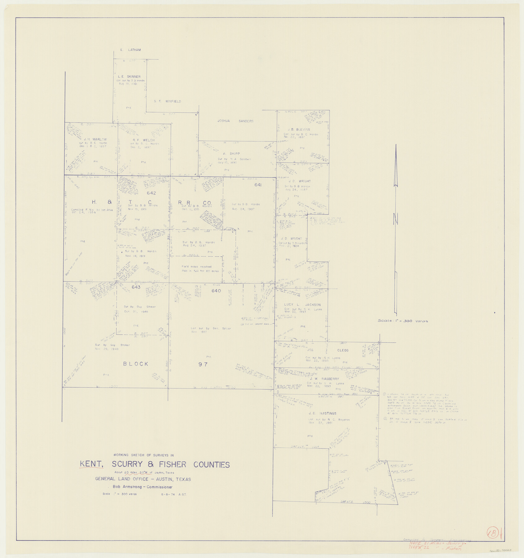
Kent County Working Sketch 18
-
Map/Doc
70025
-
Collection
General Map Collection
-
Object Dates
8/8/1974 (Creation Date)
-
People and Organizations
Abner G. Trigg (Draftsman)
-
Counties
Kent Scurry Fisher
-
Subjects
Surveying Working Sketch
-
Height x Width
33.5 x 31.5 inches
85.1 x 80.0 cm
-
Scale
1" = 300 varas
Part of: General Map Collection
Flight Mission No. DQN-2K, Frame 99, Calhoun County

Print $20.00
- Digital $50.00
Flight Mission No. DQN-2K, Frame 99, Calhoun County
1953
Size 18.7 x 22.3 inches
Map/Doc 84289
Deaf Smith County Sketch File D(a)

Print $30.00
- Digital $50.00
Deaf Smith County Sketch File D(a)
1905
Size 9.4 x 8.8 inches
Map/Doc 20643
Texas State Boundary Line 4

Print $20.00
- Digital $50.00
Texas State Boundary Line 4
Size 11.2 x 8.7 inches
Map/Doc 74949
[Surveys along the Leon River and Plum Creek]
![255, [Surveys along the Leon River and Plum Creek], General Map Collection](https://historictexasmaps.com/wmedia_w700/maps/255.tif.jpg)
Print $2.00
- Digital $50.00
[Surveys along the Leon River and Plum Creek]
1846
Size 11.7 x 7.6 inches
Map/Doc 255
Jim Hogg County Rolled Sketch F

Print $20.00
- Digital $50.00
Jim Hogg County Rolled Sketch F
1930
Size 24.5 x 28.9 inches
Map/Doc 6445
Flight Mission No. DQN-7K, Frame 38, Calhoun County

Print $20.00
- Digital $50.00
Flight Mission No. DQN-7K, Frame 38, Calhoun County
1953
Size 18.5 x 22.2 inches
Map/Doc 84476
Map of Matagorda Bay and County with the Adjacent Country

Print $20.00
- Digital $50.00
Map of Matagorda Bay and County with the Adjacent Country
1839
Size 33.4 x 42.6 inches
Map/Doc 2002
Go Turnpike! Dallas-Fort Worth Turnpike (Recto)

Go Turnpike! Dallas-Fort Worth Turnpike (Recto)
1963
Size 11.2 x 17.2 inches
Map/Doc 94177
Aransas County Boundary File 2

Print $3.00
- Digital $50.00
Aransas County Boundary File 2
Size 12.4 x 10.8 inches
Map/Doc 49781
[Sketch in DeWitt County]
![78383, [Sketch in DeWitt County], General Map Collection](https://historictexasmaps.com/wmedia_w700/maps/78383.tif.jpg)
Print $3.00
- Digital $50.00
[Sketch in DeWitt County]
Size 9.3 x 10.1 inches
Map/Doc 78383
Montgomery County Sketch File 16

Print $26.00
- Digital $50.00
Montgomery County Sketch File 16
1896
Size 14.2 x 8.8 inches
Map/Doc 31819
Archer County Working Sketch Graphic Index

Print $20.00
- Digital $50.00
Archer County Working Sketch Graphic Index
1926
Size 46.7 x 39.4 inches
Map/Doc 76456
You may also like
Sherman County Rolled Sketch 12

Print $40.00
- Digital $50.00
Sherman County Rolled Sketch 12
1951
Size 11.1 x 63.8 inches
Map/Doc 9929
Flight Mission No. BRE-2P, Frame 137, Nueces County

Print $20.00
- Digital $50.00
Flight Mission No. BRE-2P, Frame 137, Nueces County
1956
Size 18.6 x 22.4 inches
Map/Doc 86810
Right of Way & Track Map San Antonio & Aransas Pass Railway Co.

Print $40.00
- Digital $50.00
Right of Way & Track Map San Antonio & Aransas Pass Railway Co.
1919
Size 25.3 x 56.5 inches
Map/Doc 64024
Culberson County Working Sketch 33

Print $20.00
- Digital $50.00
Culberson County Working Sketch 33
1960
Size 26.9 x 34.1 inches
Map/Doc 68486
Central Lea County, New Mexico

Print $40.00
- Digital $50.00
Central Lea County, New Mexico
Size 40.6 x 60.2 inches
Map/Doc 89909
Randall County Working Sketch 1

Print $20.00
- Digital $50.00
Randall County Working Sketch 1
1974
Size 28.0 x 31.6 inches
Map/Doc 71838
[Sketch showing Capitol Lands]
![89725, [Sketch showing Capitol Lands], Twichell Survey Records](https://historictexasmaps.com/wmedia_w700/maps/89725-1.tif.jpg)
Print $40.00
- Digital $50.00
[Sketch showing Capitol Lands]
Size 38.3 x 72.0 inches
Map/Doc 89725
Polk County Working Sketch 24

Print $20.00
- Digital $50.00
Polk County Working Sketch 24
1957
Size 24.8 x 25.3 inches
Map/Doc 71640
Matagorda County Sketch File 46

Print $107.00
- Digital $50.00
Matagorda County Sketch File 46
1985
Size 11.2 x 8.5 inches
Map/Doc 30932
Live Oak County Sketch File 22

Print $20.00
- Digital $50.00
Live Oak County Sketch File 22
Size 17.4 x 9.7 inches
Map/Doc 30299
Jefferson County Sketch File 6

Print $4.00
- Digital $50.00
Jefferson County Sketch File 6
1860
Size 12.3 x 7.8 inches
Map/Doc 28110
Atascosa County

Print $20.00
- Digital $50.00
Atascosa County
1948
Size 47.6 x 44.9 inches
Map/Doc 77204