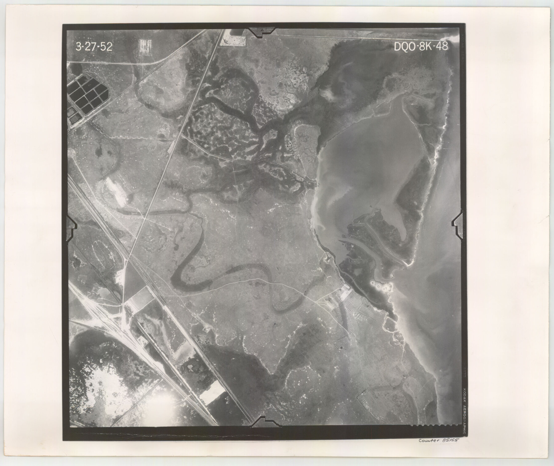
Flight Mission No. DQO-8K, Frame 48, Galveston County
DQO-8K-48
-
Map/Doc
85155
-
Collection
General Map Collection
-
Object Dates
1952/3/27 (Creation Date)
-
People and Organizations
U. S. Department of Agriculture (Publisher)
-
Counties
Galveston
-
Subjects
Aerial Photograph
-
Height x Width
18.7 x 22.2 inches
47.5 x 56.4 cm
-
Comments
Flown by Aero Exploration Company of Tulsa, Oklahoma.
Part of: General Map Collection
Flight Mission No. CRK-5P, Frame 130, Refugio County
![86933, Flight Mission No. CRK-5P, Frame 130, Refugio County, General Map Collection](https://historictexasmaps.com/wmedia_w700/pdf_converted_jpg/qi_pdf_thumbnail_34067.jpg)
Print $20.00
- Digital $50.00
Flight Mission No. CRK-5P, Frame 130, Refugio County
1956
Size 18.6 x 22.5 inches
Map/Doc 86933
Shelby County Working Sketch 29b
![63884, Shelby County Working Sketch 29b, General Map Collection](https://historictexasmaps.com/wmedia_w700/maps/63884.tif.jpg)
Print $20.00
- Digital $50.00
Shelby County Working Sketch 29b
Size 25.2 x 37.8 inches
Map/Doc 63884
Wilbarger Co.
![16927, Wilbarger Co., General Map Collection](https://historictexasmaps.com/wmedia_w700/maps/16927.tif.jpg)
Print $40.00
- Digital $50.00
Wilbarger Co.
1907
Size 49.0 x 39.3 inches
Map/Doc 16927
Palo Pinto County Working Sketch 24
![71407, Palo Pinto County Working Sketch 24, General Map Collection](https://historictexasmaps.com/wmedia_w700/maps/71407.tif.jpg)
Print $20.00
- Digital $50.00
Palo Pinto County Working Sketch 24
Size 33.2 x 33.7 inches
Map/Doc 71407
Kleberg County Sketch File 1
![29192, Kleberg County Sketch File 1, General Map Collection](https://historictexasmaps.com/wmedia_w700/pdf_converted_jpg/qi_pdf_thumbnail_12500.jpg)
Print $36.00
- Digital $50.00
Kleberg County Sketch File 1
1994
Size 8.8 x 11.3 inches
Map/Doc 29192
Val Verde County Sketch File Z2
![](https://historictexasmaps.com/wmedia_w700/pdf_converted_jpg/qi_pdf_thumbnail_71013.jpg)
Print $31.00
- Digital $50.00
Val Verde County Sketch File Z2
1881
Size 16.7 x 10.7 inches
Map/Doc 39114
Hudspeth County Rolled Sketch 66
![6263, Hudspeth County Rolled Sketch 66](https://historictexasmaps.com/wmedia_w700/maps/6263.tif.jpg)
Print $20.00
- Digital $50.00
Hudspeth County Rolled Sketch 66
1973
Size 11.7 x 18.2 inches
Map/Doc 6263
Old Miscellaneous File 35
![75757, Old Miscellaneous File 35, General Map Collection](https://historictexasmaps.com/wmedia_w700/pdf_converted_jpg/qi_pdf_thumbnail_28105.jpg)
Print $4.00
- Digital $50.00
Old Miscellaneous File 35
1882
Size 13.9 x 8.6 inches
Map/Doc 75757
Cherokee County Sketch File 29
![18175, Cherokee County Sketch File 29, General Map Collection](https://historictexasmaps.com/wmedia_w700/pdf_converted_jpg/qi_pdf_thumbnail_10082.jpg)
Print $2.00
- Digital $50.00
Cherokee County Sketch File 29
Size 12.9 x 8.2 inches
Map/Doc 18175
Sutton County Sketch File 6
![37358, Sutton County Sketch File 6, General Map Collection](https://historictexasmaps.com/wmedia_w700/pdf_converted_jpg/qi_pdf_thumbnail_14356.jpg)
Print $8.00
- Digital $50.00
Sutton County Sketch File 6
1897
Size 14.0 x 9.0 inches
Map/Doc 37358
Presidio County Working Sketch 9a
![71684, Presidio County Working Sketch 9a, General Map Collection](https://historictexasmaps.com/wmedia_w700/maps/71684.tif.jpg)
Print $20.00
- Digital $50.00
Presidio County Working Sketch 9a
Size 17.3 x 12.2 inches
Map/Doc 71684
Sutton County Sketch File 48
![37521, Sutton County Sketch File 48, General Map Collection](https://historictexasmaps.com/wmedia_w700/pdf_converted_jpg/qi_pdf_thumbnail_14385.jpg)
Print $4.00
- Digital $50.00
Sutton County Sketch File 48
1939
Size 11.3 x 8.7 inches
Map/Doc 37521
You may also like
Crockett County Working Sketch 76
![68409, Crockett County Working Sketch 76, General Map Collection](https://historictexasmaps.com/wmedia_w700/maps/68409.tif.jpg)
Print $20.00
- Digital $50.00
Crockett County Working Sketch 76
1964
Size 34.3 x 36.3 inches
Map/Doc 68409
Galveston Bay and Approaches
![69875, Galveston Bay and Approaches, General Map Collection](https://historictexasmaps.com/wmedia_w700/maps/69875.tif.jpg)
Print $20.00
- Digital $50.00
Galveston Bay and Approaches
1938
Size 45.4 x 34.6 inches
Map/Doc 69875
Clay County Boundary File 17
![51432, Clay County Boundary File 17, General Map Collection](https://historictexasmaps.com/wmedia_w700/pdf_converted_jpg/qi_pdf_thumbnail_15768.jpg)
Print $8.00
- Digital $50.00
Clay County Boundary File 17
Size 13.8 x 8.4 inches
Map/Doc 51432
Supreme Court of the United States, October Term, 1923, No. 15, Original - The State of Oklahoma, Complainant vs. The State of Texas, Defendant, The United States, Intervener; Report of the Boundary Commissioners
![82996, Supreme Court of the United States, October Term, 1923, No. 15, Original - The State of Oklahoma, Complainant vs. The State of Texas, Defendant, The United States, Intervener; Report of the Boundary Commissioners, General Map Collection](https://historictexasmaps.com/wmedia_w700/maps/82996.tif.jpg)
Print $20.00
- Digital $50.00
Supreme Court of the United States, October Term, 1923, No. 15, Original - The State of Oklahoma, Complainant vs. The State of Texas, Defendant, The United States, Intervener; Report of the Boundary Commissioners
1923
Size 35.1 x 41.1 inches
Map/Doc 82996
Presidio County Sketch File 6a
![34437, Presidio County Sketch File 6a, General Map Collection](https://historictexasmaps.com/wmedia_w700/pdf_converted_jpg/qi_pdf_thumbnail_13692.jpg)
Print $2.00
- Digital $50.00
Presidio County Sketch File 6a
Size 7.9 x 6.6 inches
Map/Doc 34437
Aransas County Rolled Sketch 31A
![77499, Aransas County Rolled Sketch 31A, General Map Collection](https://historictexasmaps.com/wmedia_w700/maps/77499.tif.jpg)
Print $20.00
- Digital $50.00
Aransas County Rolled Sketch 31A
1950
Size 25.1 x 42.4 inches
Map/Doc 77499
Gillespie County Rolled Sketch 7
![88818, Gillespie County Rolled Sketch 7, General Map Collection](https://historictexasmaps.com/wmedia_w700/maps/88818.tif.jpg)
Print $20.00
- Digital $50.00
Gillespie County Rolled Sketch 7
2008
Size 18.9 x 18.8 inches
Map/Doc 88818
Flight Mission No. BRE-1P, Frame 115, Nueces County
![86681, Flight Mission No. BRE-1P, Frame 115, Nueces County, General Map Collection](https://historictexasmaps.com/wmedia_w700/pdf_converted_jpg/qi_pdf_thumbnail_33820.jpg)
Print $20.00
- Digital $50.00
Flight Mission No. BRE-1P, Frame 115, Nueces County
1956
Size 18.4 x 22.2 inches
Map/Doc 86681
Menard County Boundary File 12a
![57114, Menard County Boundary File 12a, General Map Collection](https://historictexasmaps.com/wmedia_w700/pdf_converted_jpg/qi_pdf_thumbnail_16537.jpg)
Print $14.00
- Digital $50.00
Menard County Boundary File 12a
Size 14.2 x 8.8 inches
Map/Doc 57114
Location Map of Memphis, El Paso & Pacific Railroad through Medina & Uvalde Counties
![64444, Location Map of Memphis, El Paso & Pacific Railroad through Medina & Uvalde Counties, General Map Collection](https://historictexasmaps.com/wmedia_w700/maps/64444.tif.jpg)
Print $40.00
- Digital $50.00
Location Map of Memphis, El Paso & Pacific Railroad through Medina & Uvalde Counties
1882
Size 19.2 x 102.0 inches
Map/Doc 64444
Flight Mission No. CUG-3P, Frame 83, Kleberg County
![86258, Flight Mission No. CUG-3P, Frame 83, Kleberg County, General Map Collection](https://historictexasmaps.com/wmedia_w700/pdf_converted_jpg/qi_pdf_thumbnail_33402.jpg)
Print $20.00
- Digital $50.00
Flight Mission No. CUG-3P, Frame 83, Kleberg County
1956
Size 18.7 x 22.4 inches
Map/Doc 86258
Gonzales County Sketch File 5
![24377, Gonzales County Sketch File 5, General Map Collection](https://historictexasmaps.com/wmedia_w700/pdf_converted_jpg/qi_pdf_thumbnail_11438.jpg)
Print $16.00
- Digital $50.00
Gonzales County Sketch File 5
1879
Size 10.0 x 8.1 inches
Map/Doc 24377